Grade I listed buildings in Carmarthenshire
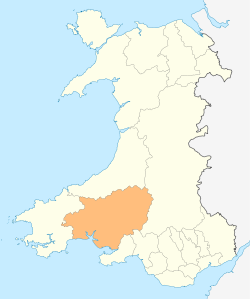
Carmarthenshire shown within Wales
In the United Kingdom, the term listed building refers to a building or other structure officially designated as being of special architectural, historical, or cultural significance; Grade I structures are those considered to be "buildings of exceptional interest".[1] Listing was begun by a provision in the Town and Country Planning Act 1947. Once listed, strict limitations are imposed on the modifications allowed to a building's structure or fittings. In Wales, the authority for listing under the Planning (Listed Buildings and Conservation Areas) Act 1990[2] rests with Cadw.
Buildings
| Name | Location | Date Listed | Grid Ref.[note 1] Geo-coordinates |
Function | Notes | HB No[note 2] | Image |
|---|---|---|---|---|---|---|---|
| Church of St Margaret Marloes | Eglwyscummin | 30 November 1966 | SN2309010649 51°45′59″N 4°33′55″W / 51.766485359737°N 4.5651784716532°W |
Church | Situated in a prominent position on the N side of the B4314, some 2.5km SE of Rhos-goch. | 9389 | 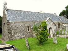
|
| Llansteffan Castle | Llansteffan | 30 November 1966 | SN3514110148 51°45′56″N 4°23′26″W / 51.765673538851°N 4.3904680276349°W |
Castle | Prominently situated on a rocky promontery, overlooking the mouth of the Tywi. | 9405 | 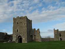
|
| Parish Church of St Peter, Carmarthen | Carmarthen | 18 August 1954 | SN4152320221 51°51′29″N 4°18′10″W / 51.858014060302°N 4.3026750809433°W |
Church | Situated in rounded churchyard at end of King Street. | 9435 | 
|
| Carmarthen Castle | Carmarthen | 18 August 1954 | SN4130820006 51°51′22″N 4°18′21″W / 51.856021331313°N 4.3056956078448°W |
Castle | Situated behind buildings on E side of Nott's Square. | 9507 | 
|
| Outer Gatehouse to Laugharne Castle | Laugharne Township | 25 September 1986 | SN3020210794 51°46′12″N 4°27′44″W / 51.769996314861°N 4.4622874287369°W |
Gatehouse | 9652 | 
| |
| Laugharne Castle | Laugharne Township | 30 November 1966 | SN3021710752 51°46′11″N 4°27′43″W / 51.769623603298°N 4.462049709389°W |
Castle | 9653 | 
| |
| Newcastle Emlyn Castle | Newcastle Emlyn | 8 May 1991 | SN3114240724 52°02′21″N 4°27′48″W / 52.039128924761°N 4.4633503651072°W |
Castle | 9716 | 
| |
| Church of St Michael, Cilycwm | Cilycwm | 7 August 1966 | SN7533340029 52°02′41″N 3°49′09″W / 52.044611649089°N 3.8192098171757°W |
Church | Situated on E side of village street, in centre of village. | 10906 | 
|
| Plas Taliaris | Manordeilo and Salem | 7 August 1966 | SN6400427984 51°56′01″N 3°58′46″W / 51.93371443426°N 3.9795174176033°W |
Hall | 10911 | 
| |
| Dryslwyn Castle | Llangathen | 7 August 1966 | SN5540320365 51°51′47″N 4°06′05″W / 51.863086444876°N 4.1013355233841°W |
Castle | On high ground overlooking the Tywi Valley, to the E of the B4297 and on the N side of the river. | 10934 | 
|
| Church of St Michael, Myddfai | Myddfai | 7 August 1966 | SN7723830139 51°57′22″N 3°47′16″W / 51.956163311575°N 3.7879016017424°W |
Church | Situated in rounded churchyard in centre of the village. | 10957 | 
|
| Dolauhirion Bridge | Llandovery | 3 August 1966 | SN7619736098 52°00′34″N 3°48′19″W / 52.009481070973°N 3.8051949579892°W |
Bridge | Situated some 1.5km north of Llandovery, carrying road to Cilycwm and Porthrhyd across River Tywi. | 10964 | 
|
| Church of St Mary, Llandovery | Llandovery | 3 August 1966 | SN7698335161 52°00′04″N 3°47′36″W / 52.001236071187°N 3.7934124878727°W |
Church | Situated on small hill above the modern A483 in large churchyard. | 10967 | 
|
| Dinefwr Castle | Llandeilo | 7 August 1966 | SN6114921730 51°52′37″N 4°01′07″W / 51.876814284337°N 4.0184949735057°W |
Castle | 11117 | 
| |
| Kidwelly Castle | Kidwelly | 5 December 1963 | SN4089707049 51°44′22″N 4°18′21″W / 51.739502562072°N 4.305709926741°W |
Castle | Situated on a bluff above W bank of Gwendraeth Fach, across river from modern town centre. | 11876 | 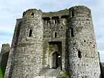
|
| Church of Saint Mary, Kidwelly | Kidwelly | 5 December 1963 | SN4084206750 51°44′12″N 4°18′23″W / 51.736800754749°N 4.3063689606529°W |
Church | Situated in centre of Kidwelly in large walled churchyard. | 11878 | 
|
| Llanelly House (2 Bridge Street) | Llanelli | 17 June 1966 | SN5067300503 51°41′00″N 4°09′41″W / 51.683385690127°N 4.1614288066676°W |
House | Situated on corner of Vaughan Street and Bridge Street, facing Parish Church. | 11892 | 
|
| Llanelly House (4 Bridge Street) | Llanelli | 17 June 1966 | SN5068000503 51°41′00″N 4°09′41″W / 51.683387556025°N 4.1613276288578°W |
House | 11893 |
| |
| Llanelly House, rear wing (20 Vaughan Street) | Llanelli | 17 June 1966 | SN5066900489 51°41′00″N 4°09′41″W / 51.683258837302°N 4.1614806295338°W |
House | 11894 | 
| |
| Llanelly House, rear wing (22 Vaughan Street) | Llanelli | 17 June 1966 | SN5066800496 51°41′00″N 4°09′41″W / 51.683321464011°N 4.1614980799895°W |
House | 11895 |
| |
| Llanelly House (24 Vaughan Street) | Llanelli | 17 June 1966 | SN5066700502 51°41′00″N 4°09′41″W / 51.683375105962°N 4.1615151024159°W |
House | 11896 |
| |
| Dolauhirion Bridge | Cilycwm | 3 August 1966 | SN7620636100 52°00′34″N 3°48′18″W / 52.00950105493°N 3.8050646240583°W |
Bridge | Situated some 1.5km north of Llandovery, carrying road to Cilycwm and Porthrhyd across River Tywi | 16996 |
|
| Carreg Cennen Castle | Dyffryn Cennen | 24 November 1998 | SN6681419093 51°51′16″N 3°56′07″W / 51.854503676338°N 3.9352338825242°W |
Castle | Spectacularly set on a crag over the upper Cennen valley, approached from Carreg Cennen Farm, about 1.5 km E of Trap. | 20923 | 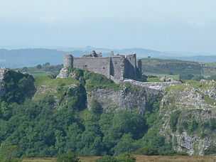 |
See also
Notes
- ↑ Sometimes known as OSGB36, the grid reference is based on the British national grid reference system used by the Ordnance Survey.
- ↑ The "HB Number" is a unique number assigned to each listed building by Cadw.
References
- ↑ "Buildings & Conservation Areas". Cadw. Retrieved 18 June 2013.
- ↑ "Planning (Listed Buildings and Conservation Areas) Act 1990". The National Archives. Retrieved 18 June 2013.
External links
![]() Media related to Grade I listed buildings in Carmarthenshire at Wikimedia Commons
Media related to Grade I listed buildings in Carmarthenshire at Wikimedia Commons
| ||||||||||||||||||||||||||