| Name |
Location |
Type |
Completed | Date designated |
Grid ref.
Geo-coordinates |
Entry number | Image |
|
|
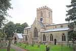
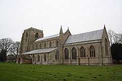
| Church of St Peter and St Paul |
Algarkirk |
Church |
1799 |
01967-01-26-000026 January 1967 |
TF2912435289
52°53′58″N 0°04′54″W / 52.899541°N 0.081803°W / 52.899541; -0.081803 (Church of St Peter and St Paul) |
1164857 |
More images
|
| Church of All Saints |
Benington |
Parish church |
1210 !Early 13th century |
01967-01-26-000026 January 1967 |
TF3971246511
52°59′52″N 0°04′49″E / 52.997707°N 0.080329°E / 52.997707; 0.080329 (Church of All Saints) |
1062077 |
|
| Church of St Swithin |
Bicker |
Church |
1150 !12th century |
01967-01-26-000026 January 1967 |
TF2245737863
52°55′27″N 0°10′48″W / 52.924226°N 0.179893°W / 52.924226; -0.179893 (Church of St Swithin) |
1062014 |
|
| Church of St Andrew |
Butterwick |
Parish church |
1250 !13th century |
01967-01-26-000026 January 1967 |
TF3876544924
52°59′01″N 0°03′56″E / 52.983696°N 0.065548°E / 52.983696; 0.065548 (Church of St Andrew) |
1308528 |
|
| Church of St Guthlac |
Fishtoft |
Parish church |
1150 !12th century |
01967-01-26-000026 January 1967 |
TF3644842544
52°57′46″N 0°01′48″E / 52.96291°N 0.030056°E / 52.96291; 0.030056 (Church of St Guthlac) |
1147452 |
More images
|
| Rochford Tower |
Fishtoft |
House |
1807 |
01967-01-26-000026 January 1967 |
TF3509644496
52°58′51″N 0°00′39″E / 52.980788°N 0.010755°E / 52.980788; 0.010755 (Rochford Tower) |
1062088 |
|
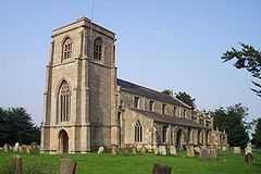
| Church of St Mary |
Frampton |
Parish church |
1190 !Late 12th century |
01967-01-26-000026 January 1967 |
TF3257639169
52°56′01″N 0°01′44″W / 52.933559°N 0.028933°W / 52.933559; -0.028933 (Church of St Mary) |
1360476 |
More images
|
| Church of St James |
Freiston |
Parish church |
1550 !16th century |
01967-01-26-000026 January 1967 |
TF3772943770
52°58′25″N 0°02′59″E / 52.973596°N 0.049636°E / 52.973596; 0.049636 (Church of St James) |
1308415 |
More images
|
| Church of St Peter and St Paul |
Kirton |
Church |
1151 !Mid-12th century |
01967-01-26-000026 January 1967 |
TF3049338527
52°55′42″N 0°03′37″W / 52.928301°N 0.060163°W / 52.928301; -0.060163 (Church of St Peter and St Paul) |
1062022 |
More images
|
| Church of St Helen |
Leverton |
Parish church |
1350 !14th century |
01967-01-26-000026 January 1967 |
TF3999547889
53°00′36″N 0°05′07″E / 53.010012°N 0.08514°E / 53.010012; 0.08514 (Church of St Helen) |
1062072 |
More images
|
| Church of St Mary |
Old Leake |
Church |
1150 !12th century |
01967-01-26-000026 January 1967 |
TF4074450281
53°01′53″N 0°05′50″E / 53.031303°N 0.097337°E / 53.031303; 0.097337 (Church of St Mary) |
1147754 |
|
| Church of St Mary |
Sutterton |
Parish church |
1190 !Late 12th century |
01967-01-26-000026 January 1967 |
TF2849235558
52°54′08″N 0°05′28″W / 52.902109°N 0.091087°W / 52.902109; -0.091087 (Church of St Mary) |
1360517 |
More images
|
| Church of St Mary |
Swineshead |
Parish church |
1300 !c.1300 |
01967-01-26-000026 January 1967 |
TF2375340193
52°56′42″N 0°09′35″W / 52.944863°N 0.159738°W / 52.944863; -0.159738 (Church of St Mary) |
1232860 |
More images
|
| Church of St Peter and St Paul |
Wigtoft |
Parish church |
1150 !12th century |
01967-01-26-000026 January 1967 |
TF2628336230
52°54′31″N 0°07′25″W / 52.908669°N 0.123649°W / 52.908669; -0.123649 (Church of St Peter and St Paul) |
1237405 |
|
| Church of St Mary and St Nicholas |
Wrangle |
Parish church |
1200 !c.1200 |
01967-01-26-000026 January 1967 |
TF4248450854
53°02′10″N 0°07′25″E / 53.03599°N 0.123518°E / 53.03599; 0.123518 (Church of St Mary and St Nicholas) |
1308367 |
More images
|
| Sundial in south side of churchyard of Church of St Mary and St Nicholas |
Wrangle |
Sundial |
1826 |
01987-08-26-000026 August 1987 |
TF4248050818
53°02′08″N 0°07′24″E / 53.035668°N 0.123442°E / 53.035668; 0.123442 (Sundial in south side of churchyard of Church of St Mary and St Nicholas) |
1360465 |
|
| Church of St Leodegar |
Wyberton |
Parish church |
1190 !Late 12th century |
01967-01-26-000026 January 1967 |
TF3286740831
52°56′54″N 0°01′26″W / 52.948418°N 0.023926°W / 52.948418; -0.023926 (Church of St Leodegar) |
1147881 |
More images
|
| Fydell House and wall and railings and two urns |
Boston |
House |
1726 |
01949-05-27-000027 May 1949 |
TF3285543876
52°58′33″N 0°01′22″W / 52.975777°N 0.022857°W / 52.975777; -0.022857 (Fydell House and wall and railings and two urns) |
1388995 |
|
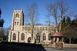
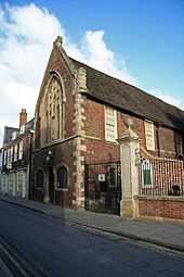
| Guildhall and attached gate |
Boston |
Guildhall |
1390 !Late 14th century |
01975-11-20-000020 November 1975 |
TF3286543891
52°58′33″N 0°01′22″W / 52.975909°N 0.022702°W / 52.975909; -0.022702 (Guildhall and attached gate) |
1389007 |
|
| Maud Foster Windmill and Granary |
Boston |
Tower mill |
1819 |
01949-05-27-000027 May 1949 |
TF3317244754
52°59′01″N 0°01′04″W / 52.983586°N 0.017778°W / 52.983586; -0.017778 (Maud Foster Windmill and Granary) |
1389071 |
More images
|
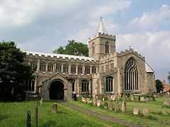
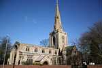
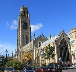
| Parish Church of St Botolph |
Boston |
Church |
1400 !c.1400 |
01949-05-27-000027 May 1949 |
TF3269244184
52°58′43″N 0°01′31″W / 52.978585°N 0.025157°W / 52.978585; -0.025157 (Parish Church of St Botolph) |
1388844 |
More images |