| Name |
Location |
Type |
Completed | Date designated |
Grid ref.
Geo-coordinates |
Entry number | Image |
|
|
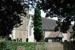
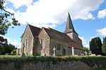
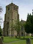
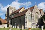
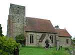
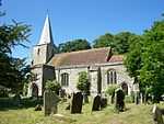
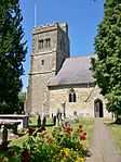
| Church of St Martin |
Aldington |
Church |
1050 !11th century (Saxo Norman) |
01988-08-10-000010 August 1988 |
TR0749936183
51°05′15″N 0°57′41″E / 51.087417°N 0.961491°E / 51.087417; 0.961491 (Church of St Martin) |
1071208 |
More images
|
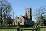
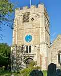
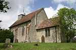
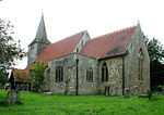
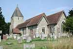
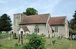
| Church of St Peter and St Paul |
Appledore |
Church |
1250 !13th century |
01962-08-16-000016 August 1962 |
TQ9576429282
51°01′46″N 0°47′25″E / 51.029558°N 0.790416°E / 51.029558; 0.790416 (Church of St Peter and St Paul) |
1071031 |
More images
|
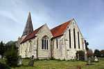
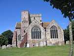
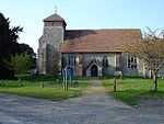
| Parish Church of St Mary the Virgin |
Ashford |
Church |
1350 !14th century |
01951-09-24-000024 September 1951 |
TR0102042727
51°08′55″N 0°52′22″E / 51.148493°N 0.872748°E / 51.148493; 0.872748 (Parish Church of St Mary the Virgin) |
1071114 |
More images
|
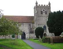
| Church of St Margaret |
Bethersden |
Church |
1350 !14th century |
01967-02-14-000014 February 1967 |
TQ9279240264
51°07′45″N 0°45′14″E / 51.129199°N 0.753938°E / 51.129199; 0.753938 (Church of St Margaret) |
1070794 |
More images
|
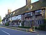
| New Biddenden Stores/The Maydes Restaurant/Ye Ancient House |
Biddenden |
House |
1550 !16th century or earlier |
01952-06-04-00004 June 1952 |
TQ8506538392
51°06′54″N 0°38′34″E / 51.114931°N 0.642675°E / 51.114931; 0.642675 (New Biddenden Stores/The Maydes Restaurant/Ye Ancient House) |
1184943 |
|
| Old Cloth Workers Hall or The Old Cloth Hall |
Biddenden |
Manor house |
1450 !15th century |
01952-06-04-00004 June 1952 |
TQ8511138503
51°06′57″N 0°38′36″E / 51.115913°N 0.643388°E / 51.115913; 0.643388 (Old Cloth Workers Hall or The Old Cloth Hall) |
1070982 |

|
| Parish Church of All Saints |
Biddenden |
Church |
1210 !Early 13th century |
01962-08-16-000016 August 1962 |
TQ8490938408
51°06′54″N 0°38′26″E / 51.115125°N 0.640457°E / 51.115125; 0.640457 (Parish Church of All Saints) |
1070978 |
More images
|
| St Augustines Priory (medieval buildings) |
Bilsington |
Monastic buildings |
1536 |
01952-10-13-000013 October 1952 |
TR0434135525
51°04′58″N 0°54′58″E / 51.082641°N 0.916089°E / 51.082641; 0.916089 (St Augustines Priory (medieval buildings)) |
1362769 |
|
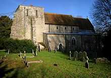
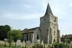
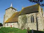
| Church of St Rumwold |
Bonnington |
Manor house |
1150 !12th century |
01957-11-27-000027 November 1957 |
TR0571534426
51°04′20″N 0°56′06″E / 51.072281°N 0.935054°E / 51.072281; 0.935054 (Church of St Rumwold) |
1071194 |
More images
|
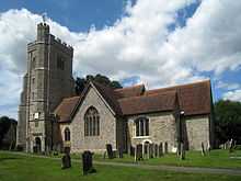
| Church of All Saints |
Boughton Aluph |
Church |
1250 !13th century |
01957-11-27-000027 November 1957 |
TR0332048144
51°11′47″N 0°54′31″E / 51.196328°N 0.908649°E / 51.196328; 0.908649 (Church of All Saints) |
1299904 |
More images
|
| Church of St Mary |
Brabourne |
Church |
1190 !Late 12th century |
01957-11-27-000027 November 1957 |
TR1036041678
51°08′09″N 1°00′20″E / 51.135719°N 1.005484°E / 51.135719; 1.005484 (Church of St Mary) |
1232793 |
More images
|
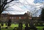
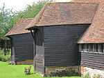
| Barn with sheds about 50 metres west of Court Lodge |
Brook |
Museum |
1375 !Mid- to late 14th century |
01989-02-16-000016 February 1989 |
TR0657544265
51°09′37″N 0°57′11″E / 51.160328°N 0.952943°E / 51.160328; 0.952943 (Barn with sheds about 50 metres west of Court Lodge) |
1233070 |
|
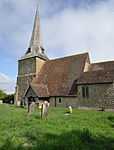
| Church of St Mary |
Brook |
Church |
1096–1107 |
01957-11-27-000027 November 1957 |
TR0663544281
51°09′38″N 0°57′14″E / 51.16045°N 0.953809°E / 51.16045; 0.953809 (Church of St Mary) |
1232974 |
More images
|
| Barn to south-east of Palace Farmhouse |
Charing |
Barn |
1333–48 |
01967-02-14-000014 February 1967 |
TQ9543649426
51°12′38″N 0°47′48″E / 51.210591°N 0.796654°E / 51.210591; 0.796654 (Barn to south-east of Palace Farmhouse) |
1185861 |
|
| Church of St Peter and St Paul |
Charing |
Church |
1250 !13th century |
01967-02-14-000014 February 1967 |
TQ9544249383
51°12′37″N 0°47′48″E / 51.210202°N 0.796716°E / 51.210202; 0.796716 (Church of St Peter and St Paul) |
1362985 |
More images
|
| Outhouse to west of Palace Farmhouse |
Charing |
Farm building |
1350 !14th century |
01967-02-14-000014 February 1967 |
TQ9537749441
51°12′39″N 0°47′45″E / 51.210745°N 0.795818°E / 51.210745; 0.795818 (Outhouse to west of Palace Farmhouse) |
1186008 |
|
| Palace Cottages and the remains of the gatehouse adjoining |
Charing |
Archbishops palace |
1350 !14th century |
01967-02-14-000014 February 1967 |
TQ9539249412
51°12′38″N 0°47′46″E / 51.21048°N 0.796017°E / 51.21048; 0.796017 (Palace Cottages and the remains of the gatehouse adjoining) |
1070757 |
|
| Palace Farmhouse |
Charing |
Archbishops palace |
1250 !13th century |
01967-02-14-000014 February 1967 |
TQ9541649446
51°12′39″N 0°47′47″E / 51.210777°N 0.796378°E / 51.210777; 0.796378 (Palace Farmhouse) |
1070756 |
|
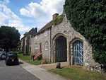
| Pett Place |
Charing |
House |
1550 !16th century |
01952-09-17-000017 September 1952 |
TQ9607649018
51°12′24″N 0°48′20″E / 51.206707°N 0.805582°E / 51.206707; 0.805582 (Pett Place) |
1071539 |
|
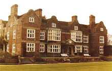
| Chilham Castle |
Chilham |
House |
1616 !1616 on frieze inscription |
01952-10-13-000013 October 1952 |
TR0668753479
51°14′35″N 0°57′35″E / 51.243028°N 0.959844°E / 51.243028; 0.959844 (Chilham Castle) |
1071304 |
More images
|
| Chilham Castle Keep and donkey wheel |
Chilham |
Keep |
1050 !11th century |
01952-10-13-000013 October 1952 |
TR0663553463
51°14′34″N 0°57′33″E / 51.242904°N 0.959091°E / 51.242904; 0.959091 (Chilham Castle Keep and donkey wheel) |
1185170 |
|
| Church of St Mary |
Chilham |
Church |
1350 !14th century |
01957-11-27-000027 November 1957 |
TR0688553656
51°14′40″N 0°57′46″E / 51.244546°N 0.962779°E / 51.244546; 0.962779 (Church of St Mary) |
1071308 |
More images
|
| Hurst Farmhouse |
Chilham |
Aisled house |
1350 !14th century |
01957-11-27-000027 November 1957 |
TR0665951824
51°13′41″N 0°57′31″E / 51.228177°N 0.95849°E / 51.228177; 0.95849 (Hurst Farmhouse) |
1071283 |
|
| Church of St Mary |
Crundale |
Church |
1150 !12th century details |
01957-11-27-000027 November 1957 |
TR0857748599
51°11′55″N 0°59′03″E / 51.19852°N 0.984047°E / 51.19852; 0.984047 (Church of St Mary) |
1299607 |
More images
|
| Church of St James |
Egerton |
Church |
1350 !14th century |
01967-02-14-000014 February 1967 |
TQ9081547556
51°11′43″N 0°43′46″E / 51.195356°N 0.729583°E / 51.195356; 0.729583 (Church of St James) |
1071496 |
|
| Church of St Lawrence |
Godmersham |
Church |
1050 !11th century |
01957-11-27-000027 November 1957 |
TR0620450451
51°12′58″N 0°57′04″E / 51.216012°N 0.951193°E / 51.216012; 0.951193 (Church of St Lawrence) |
1299528 |
|
| Godmersham Park, courtyards, walled gardens and gateways |
Godmersham Park |
House |
1732 |
01952-10-13-000013 October 1952 |
TR0615451018
51°13′16″N 0°57′03″E / 51.221122°N 0.950804°E / 51.221122; 0.950804 (Godmersham Park, courtyards, walled gardens and gateways) |
1071232 |
|
| Church of St Mary |
Great Chart with Singleton |
Church |
1250 !13th century |
01967-02-14-000014 February 1967 |
TQ9796441917
51°08′32″N 0°49′43″E / 51.142282°N 0.828667°E / 51.142282; 0.828667 (Church of St Mary) |
1115757 |
More images
|
| Godinton |
Godinton Park, Great Chart with Singleton |
House |
1628 |
01952-09-17-000017 September 1952 |
TQ9820343860
51°09′35″N 0°49′59″E / 51.15965°N 0.833148°E / 51.15965; 0.833148 (Godinton) |
1071511 |
|
| Church of St Mary |
Hastingleigh |
Church |
1050 !11th century |
01989-02-16-000016 February 1989 |
TR1019744495
51°09′40″N 1°00′17″E / 51.161075°N 1.004801°E / 51.161075; 1.004801 (Church of St Mary) |
1232978 |
More images
|
| Parish Church of St Mary |
High Halden |
Church |
1100 !Norman |
01962-08-16-000016 August 1962 |
TQ9016337237
51°06′10″N 0°42′53″E / 51.102889°N 0.714816°E / 51.102889; 0.714816 (Parish Church of St Mary) |
1185888 |
More images
|
| Church of St Margaret |
Hothfield |
Church |
1600 !Late 16th or early 17th century |
01967-02-14-000014 February 1967 |
TQ9696444528
51°09′58″N 0°48′57″E / 51.166077°N 0.815818°E / 51.166077; 0.815818 (Church of St Margaret) |
1115733 |
More images
|
| Church of St Michael |
Kingsnorth |
Church |
1450 !Largely 15th century |
01967-02-14-000014 February 1967 |
TR0061339241
51°07′02″N 0°51′54″E / 51.117328°N 0.864998°E / 51.117328; 0.864998 (Church of St Michael) |
1362667 |
More images
|
| Church of St John the Baptist |
Mersham |
Church |
1150 !12th-century origin |
01957-11-27-000027 November 1957 |
TR0526239374
51°07′01″N 0°55′53″E / 51.116878°N 0.931407°E / 51.116878; 0.931407 (Church of St John the Baptist) |
1276693 |
More images
|
| Mersham Le Hatch |
Mersham |
Country house |
1762–66 |
01952-10-13-000013 October 1952 |
TR0603240390
51°07′33″N 0°56′35″E / 51.125725°N 0.942973°E / 51.125725; 0.942973 (Mersham Le Hatch) |
1233748 |
|
| Mersham Manor |
Mersham |
House |
1790 !Late 18th century |
01957-11-27-000027 November 1957 |
TR0521439386
51°07′01″N 0°55′51″E / 51.117002°N 0.930729°E / 51.117002; 0.930729 (Mersham Manor) |
1233281 |
|
| Church of St Peter |
Molash |
Church |
1250 !13th century |
01957-11-27-000027 November 1957 |
TR0238352176
51°13′58″N 0°53′51″E / 51.232869°N 0.89753°E / 51.232869; 0.89753 (Church of St Peter) |
1185844 |
More images
|
| Church of St Nicholas |
Pluckley |
Church |
1350 !14th century |
01967-02-14-000014 February 1967 |
TQ9266945351
51°10′30″N 0°45′18″E / 51.17493°N 0.754904°E / 51.17493; 0.754904 (Church of St Nicholas) |
1362688 |
More images
|
| Parish Church of St Mary |
Rolvenden |
Church |
1250 !13th century |
01962-08-16-000016 August 1962 |
TQ8450931219
51°03′02″N 0°37′52″E / 51.050678°N 0.631081°E / 51.050678; 0.631081 (Parish Church of St Mary) |
1116287 |
More images
|
| Church of St Mary Magdalene |
Ruckinge |
Church |
1150 !12th century |
01957-11-27-000027 November 1957 |
TR0247433535
51°03′56″N 0°53′18″E / 51.065431°N 0.888356°E / 51.065431; 0.888356 (Church of St Mary Magdalene) |
1185079 |
More images
|
| Church of St Mary |
Sevington |
Church |
1150 !12th century |
01957-11-27-000027 November 1957 |
TR0370540875
51°07′51″N 0°54′36″E / 51.130912°N 0.910039°E / 51.130912; 0.910039 (Church of St Mary) |
1233902 |
More images
|
| Church of St Michael |
Smarden |
Church |
1350 !14th century |
01967-02-14-000014 February 1967 |
TQ8797742293
51°08′56″N 0°41′11″E / 51.149023°N 0.686264°E / 51.149023; 0.686264 (Church of St Michael) |
1071358 |
|
| Church of St Mary |
Smeeth |
Church |
1050 !11th century |
01957-11-27-000027 November 1957 |
TR0722539614
51°07′06″N 0°57′34″E / 51.118327°N 0.959552°E / 51.118327; 0.959552 (Church of St Mary) |
1071165 |
More images
|
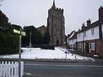
| Parish Church of St Mildred |
Tenterden |
Church |
1467 |
01950-05-08-00008 May 1950 |
TQ8836833372
51°04′08″N 0°41′14″E / 51.068765°N 0.687194°E / 51.068765; 0.687194 (Parish Church of St Mildred) |
1355024 |
More images
|
| Church of St Matthew |
Warehorne |
Church |
1250 !13th century |
01957-11-27-000027 November 1957 |
TQ9898832512
51°03′27″N 0°50′17″E / 51.057461°N 0.838107°E / 51.057461; 0.838107 (Church of St Matthew) |
1071183 |
More images
|
| Church of St Mary |
Westwell |
Church |
1250 !13th century |
01967-02-14-000014 February 1967 |
TQ9906247483
51°11′31″N 0°50′51″E / 51.191889°N 0.847422°E / 51.191889; 0.847422 (Church of St Mary) |
1068690 |
More images
|
| Parish Church of St John the Baptist |
Wittersham |
Church |
1350 !14th century |
01962-08-16-000016 August 1962 |
TQ8975026965
51°00′39″N 0°42′13″E / 51.010762°N 0.703543°E / 51.010762; 0.703543 (Parish Church of St John the Baptist) |
1070852 |
More images
|
| Parish Church of All Saints |
Woodchurch |
Church |
1250 !13th century |
01962-08-16-000016 August 1962 |
TQ9419334916
51°04′50″N 0°46′16″E / 51.080693°N 0.771061°E / 51.080693; 0.771061 (Parish Church of All Saints) |
1362956 |
More images
|
| Church of Saint Gregory and Saint Martin |
Wye with Hinxhill |
Church |
1250 !13th century |
01957-11-27-000027 November 1957 |
TR0540846904
51°11′04″N 0°56′16″E / 51.184446°N 0.937783°E / 51.184446; 0.937783 (Church of Saint Gregory and Saint Martin) |
1217135 |
More images
|
| Church of St Mary |
Hinxhill, Wye with Hinxhill |
Church |
1250 !13th century |
01957-11-27-000027 November 1957 |
TR0486142619
51°08′46″N 0°55′39″E / 51.146162°N 0.927529°E / 51.146162; 0.927529 (Church of St Mary) |
1275459 |
|
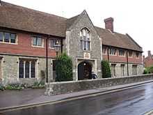
| The Latin School Wye College |
Wye with Hinxhill |
Grammar school |
1445 !c.1445 |
01952-10-13-000013 October 1952 |
TR0546446834
51°11′02″N 0°56′19″E / 51.183797°N 0.938544°E / 51.183797; 0.938544 (The Latin School Wye College) |
1217080 |
|
| Wye College, Cloister Quadrangle |
Wye with Hinxhill |
Teachers house |
1739 |
01952-10-13-000013 October 1952 |
TR0549046858
51°11′02″N 0°56′20″E / 51.184004°N 0.938929°E / 51.184004; 0.938929 (Wye College, Cloister Quadrangle) |
1275610 |
|


_-_geograph.org.uk_-_935442.jpg)