| Name |
Location |
Type |
Completed | Date designated |
Grid ref.
Geo-coordinates |
Entry number | Image |
|
|
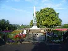
| Bromley War Memorial, St Martin's Hill |
Bromley |
War memorial |
1922 |
01995-12-14-000014 December 1995 |
TQ3997969238
51°24′18″N 0°00′40″E / 51.404902°N 0.011076°E / 51.404902; 0.011076 (Bromley War Memorial, St Martin's Hill) |
1116976 |
|
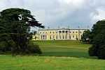
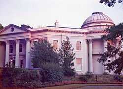
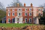
| Bullers Wood |
Chislehurst |
House |
1889 |
01973-06-29-000029 June 1973 |
TQ4243469770
51°24′33″N 0°02′48″E / 51.409072°N 0.046561°E / 51.409072; 0.046561 (Bullers Wood) |
1204400 |

|
| Camden Place |
Chislehurst |
House |
1623 !1609–23 |
01954-08-25-000025 August 1954 |
TQ4374170042
51°24′40″N 0°03′56″E / 51.411187°N 0.065451°E / 51.411187; 0.065451 (Camden Place) |
1064325 |
|
| Chesil House |
Chislehurst |
House |
1750 !18th century |
01954-08-25-000025 August 1954 |
TQ4458669981
51°24′38″N 0°04′39″E / 51.410424°N 0.077567°E / 51.410424; 0.077567 (Chesil House) |
1299045 |
More images
|
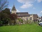
| Church of All Saints |
Orpington |
Church |
1350 !14th century |
01954-05-31-000031 May 1954 |
TQ4666166413
51°22′40″N 0°06′21″E / 51.377831°N 0.105909°E / 51.377831; 0.105909 (Church of All Saints) |
1083559 |
More images
|
| Church of St Giles the Abbot |
Farnborough, Bromley |
Church |
1640 |
01954-05-31-000031 May 1954 |
TQ4438164125
51°21′28″N 0°04′20″E / 51.357856°N 0.072243°E / 51.357856; 0.072243 (Church of St Giles the Abbot) |
1064339 |
More images
|
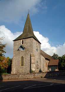
| Church of St John the Baptist |
West Wickham |
Church |
1490 !Late 15th century |
01954-05-28-000028 May 1954 |
TQ3889864854
51°21′57″N 0°00′22″W / 51.365772°N 0.006168°W / 51.365772; -0.006168 (Church of St John the Baptist) |
1359332 |
More images
|
| Lych-gate to Church of St John the Baptist's Churchyard |
West Wickham |
Lych gate |
15th century or early 16th century |
01954-05-28-000028 May 1954 |
TQ3893964849
51°21′57″N 0°00′20″W / 51.365717°N 0.005581°W / 51.365717; -0.005581 (Lych-gate to Church of St John the Baptist's Churchyard) |
1064391 |
|
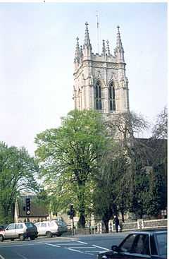
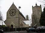
| Church of St Martin of Tours |
Bromley |
Church |
1857 |
01954-05-31-000031 May 1954 |
TQ4796064002
51°21′21″N 0°07′25″E / 51.35583°N 0.123557°E / 51.35583; 0.123557 (Church of St Martin of Tours) |
1084343 |
More images
|
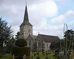
| Church of St Mary |
Orpington |
Church |
1210 !Early 13th century |
01954-05-31-000031 May 1954 |
TQ4722368367
51°23′43″N 0°06′53″E / 51.395244°N 0.114787°E / 51.395244; 0.114787 (Church of St Mary) |
1045813 |
More images
|
| Church of St Mary the Virgin |
Downe |
Church |
1250 !13th century |
01954-05-31-000031 May 1954 |
TQ4320761650
51°20′09″N 0°03′16″E / 51.335912°N 0.054399°E / 51.335912; 0.054399 (Church of St Mary the Virgin) |
1359316 |
More images
|
| Church of St Nicholas |
Chislehurst |
Church |
1460 !c.1460 |
01954-08-25-000025 August 1954 |
TQ4441769919
51°24′36″N 0°04′30″E / 51.40991°N 0.075114°E / 51.40991; 0.075114 (Church of St Nicholas) |
1064345 |
More images
|
| Church of St Paulinus |
St Paul's Cray |
Church |
1200 !Late 12th century or early 13th century |
01954-08-25-000025 August 1954 |
TQ4739369086
51°24′06″N 0°07′03″E / 51.40166°N 0.117527°E / 51.40166; 0.117527 (Church of St Paulinus) |
1064396 |
|
| Church of St Peter and St Paul |
Bromley |
Church |
1855 |
01955-01-10-000010 January 1955 |
TQ4012169245
51°24′18″N 0°00′47″E / 51.40493°N 0.013119°E / 51.40493; 0.013119 (Church of St Peter and St Paul) |
1084373 |
More images
|
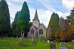
| Church of St Peter and St Paul |
Cudham |
Church |
1000 !Anglo Saxon origins |
01954-05-31-000031 May 1954 |
TQ4449759952
51°19′13″N 0°04′20″E / 51.320328°N 0.072216°E / 51.320328; 0.072216 (Church of St Peter and St Paul) |
1359355 |
More images
|
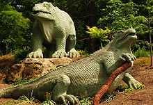
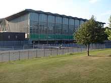
| Crystal Palace National Sports Centre |
Bromley |
Sports centre |
1964 !1960–64 |
01997-12-02-00002 December 1997 |
TQ3447570894
51°25′16″N 0°04′03″W / 51.421114°N 0.067377°W / 51.421114; -0.067377 (Crystal Palace National Sports Centre) |
1031539 |
More images
|
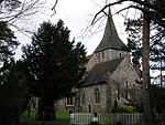
| Keston Parish Church |
Keston |
Church |
12th-century origin |
01955-01-10-000010 January 1955 |
TQ4184163002
51°20′54″N 0°02′07″E / 51.348404°N 0.035341°E / 51.348404; 0.035341 (Keston Parish Church) |
1064343 |
More images
|
| Kevington County Primary School [now Kevington Hall] |
Orpington |
Country house |
1790 !Late 18th century |
01954-05-31-000031 May 1954 |
TQ4793967640
51°23′19″N 0°07′29″E / 51.388525°N 0.124769°E / 51.388525; 0.124769 (Kevington County Primary School [now Kevington Hall)] |
1359374 |
|
| Parish Church of St George |
Beckenham |
Church |
1903 !1902–03 |
01954-05-28-000028 May 1954 |
TQ3747769644
51°24′33″N 0°01′29″W / 51.409162°N 0.024714°W / 51.409162; -0.024714 (Parish Church of St George) |
1054025 |
More images
|
| Parish Church the Annunciation of Blessed Virgin Mary |
Chislehurst |
Church |
1870 !1868–70 |
01973-06-29-000029 June 1973 |
TQ4383970931
51°25′09″N 0°04′02″E / 51.41915°N 0.067219°E / 51.41915; 0.067219 (Parish Church the Annunciation of Blessed Virgin Mary) |
1359325 |
|
| Quernmore Secondary School |
Bromley |
House |
About 1777 |
01955-01-10-000010 January 1955 |
TQ4019270453
51°24′57″N 0°00′53″E / 51.415768°N 0.014616°E / 51.415768; 0.014616 (Quernmore Secondary School) |
1055761 |
|
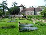
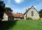
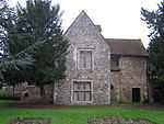
| Orpington Priory |
Orpington |
House |
1450 !15th century |
01954-05-31-000031 May 1954 |
TQ4657766533
51°22′44″N 0°06′17″E / 51.378931°N 0.104752°E / 51.378931; 0.104752 (Orpington Priory) |
1064330 |
More images |


 Media related to Grade I listed buildings in the London Borough of Bromley at Wikimedia Commons