Grade II* listed buildings in Wrexham County Borough
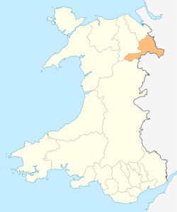
Wrexham County Borough shown within Wales
In the United Kingdom, the term listed building refers to a building or other structure officially designated as being of special architectural, historical, or cultural significance; Grade II* structures are those considered to be "particularly important buildings of more than special interest".[1] Listing was begun by a provision in the Town and Country Planning Act 1947. Once listed, strict limitations are imposed on the modifications allowed to a building's structure or fittings. In Wales, the authority for listing under the Planning (Listed Buildings and Conservation Areas) Act 1990[2] rests with Cadw.
Buildings
| Name | Location | Date Listed | Grid Ref.[note 1] Geo-coordinates |
Function | Notes | HB No[note 2] | Image |
|---|---|---|---|---|---|---|---|
| Brynkinallt Hall | Chirk | 20 October 1952 | SJ3031237867 52°56′01″N 3°02′18″W / 52.933684749593°N 3.0382564199717°W |
The Brynkinallt Estate lies to the E of Chirk town, and straddles the national boundary. | 599 | 
| |
| Dolwen | Ceiriog Ucha | 20 October 1952 | SJ1443633896 52°53′45″N 3°16′24″W / 52.8956974234°N 3.273351238031°W |
Located off a lane which runs W from the main crossroads in Llanarmon Dyffryn Ceiriog, following the River Ceiriog. The house is in a fine position on the N bank of the river with the hills rising behind. The front faces S. | 602 |
| |
| Chirk Aqueduct (continued into England) | Chirk | 1 April 1966 | SJ2869937277 52°55′41″N 3°03′44″W / 52.928169792643°N 3.0621200239043°W |
Aqueduct | The aqueduct straddles the Ceiriog Valley, approximately 55m SW of the parish church, and can be reached by a footpath from Castle Road. The aqueduct passes into England (Weston Rhyn) at its S end. | 618 | 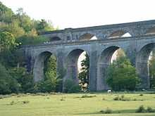
|
| Railway Viaduct over River Dee | Cefn | 1 April 1966 | SJ2852441231 52°57′49″N 3°03′56″W / 52.96368377003°N 3.0655959969677°W |
Viaduct | Carries the railway over the River Dee between Newbridge and Cefn-Bychan | 619 |
|
| Cefn (Newbridge) Viaduct (partly in Cefn Community) | Chirk | 1 April 1966 | SJ2853641173 52°57′47″N 3°03′55″W / 52.963164088457°N 3.0654045537452°W |
Viaduct | The viaduct carries the railway across the wide valley of the River Dee between Newbridge and Cefn-bychan, | 628 | 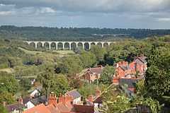
|
| Queen Anne's Cottage | Chirk | 12 March 1973 | SJ2874639985 52°57′09″N 3°03′43″W / 52.952514731581°N 3.0620169515454°W |
The cottage is located within Whitehurst Gardens, which are accessed directly from the A5 200m N of the roundabout at the N end of Chirk. | 1288 |
| |
| Trevalyn Hall (including former lodge) | Rossett | 6 September 1952 | SJ3649856798 53°06′17″N 2°57′00″W / 53.104603394416°N 2.949967901549°W |
Situated in its own grounds set back, and to the south-east, of the Chester Road (B5102) | 1528 |
| |
| Rossett Mill | Rossett | 6 September 1952 | SJ3646257035 53°06′24″N 2°57′02″W / 53.106729197663°N 2.950552519876°W |
Mill | Situated slightly back from the north-west of the B 5102 Chester Road and to the north of the main village of Rossett. Stands in its own grounds with new stable developments to the rear south of the Alyn Bridge. | 1530 | 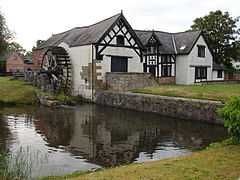
|
| Manley Hall, Erbistock | Erbistock | 6 September 1952 | SJ3498341505 52°58′01″N 2°58′10″W / 52.966970042188°N 2.9695045065286°W |
1531 |
| ||
| Esclusham Hall | Esclusham | 6 September 1952 | SJ2955748102 53°01′32″N 3°03′06″W / 53.025574840389°N 3.0517191972069°W |
Between the B5097 and the B5426 at Talwrn, S of the reservoir associated with the Legacy Waterworks. | 1534 |
| |
| Borras Hall | Holt | 6 July 1963 | SJ3712152590 53°04′01″N 2°56′23″W / 53.066856619052°N 2.93983921903°W |
Situated 0.5km N off the A534 on the by-road which runs N to Gresford. | 1563 | 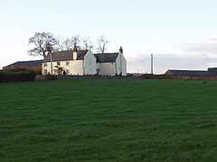
| |
| Borras Head | Holt | 6 July 1963 | SJ3670953256 53°04′22″N 2°56′46″W / 53.072793762047°N 2.9461180618708°W |
Situated to the S of Borras Road, just before the turning for the by-road which runs from the A534 to Gresford. | 1565 |
| |
| Berse vicarage with flanking walls to garden, Berse Drelincourt | Broughton | 6 July 1963 | SJ3160750856 53°03′02″N 3°01′18″W / 53.050593338199°N 3.0217454561198°W |
Vicarage | 1567 |
| |
| Dovecote at Erbistock Hall | Erbistock | 6 July 1963 | SJ3512042438 52°58′31″N 2°58′04″W / 52.975372393061°N 2.9676523386864°W |
Dovecote | 1578 |
| |
| The Groves (also known as Grove Farm), Erbistock | Erbistock | 6 July 1963 | SJ3595041999 52°58′17″N 2°57′19″W / 52.971526701665°N 2.9552067529423°W |
Farmhouse | 1580 |
| |
| Manor Farmhouse, (also known as Eyton Manor Farmhouse), Eyton | Erbistock | 6 July 1963 | SJ3547344440 52°59′36″N 2°57′46″W / 52.993408876566°N 2.9627963507615°W |
Farmhouse | 1581 |
| |
| Stable Courtyard Range | Marchwiel | 6 July 1963 | SJ3260248158 53°01′35″N 3°00′23″W / 53.0264711235°N 3.0063395594636°W |
Stables | Situated immediately to the S of the kitchen block at Erddig. | 1584 |
|
| Octagonal Building at Bersham Ironworks Site | Esclusham | 6 July 1963 | SJ3071949234 53°02′09″N 3°02′05″W / 53.035900855199°N 3.0346411069818°W |
Ironworks | In the centre of Bersham Village, towards the E end of the Ironworks site. | 1586 | 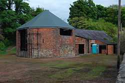
|
| Hafod-y-Bwch Hall | Esclusham | 6 July 1963 | SJ3100847863 53°01′25″N 3°01′48″W / 53.02361620993°N 3.0300383044394°W |
Between the A483 and the B5605, and approached via a drive from the B5605 immediately W of the roundabout at Croesfoel. | 1587 |
| |
| Esless Hall | Esclusham | 6 July 1963 | SJ3190949259 53°02′11″N 3°01′01″W / 53.03627865626°N 3.0169030382838°W |
Hall | Set back down a drive on the NE side of the Old Hall Farm estate on the E side of Rhostyllen, and above the River Clywedog. | 1590 |
|
| Holt Castle | Holt | 6 July 1963 | SJ4113053770 53°04′41″N 2°52′49″W / 53.077920162393°N 2.8802347075324°W |
Castle | Situated at the end of a path to the S side of Deeside. The castle remains are situated on a sandstone boss around which a quarry was later dug out. | 1595 | 
|
| Church of Saints Marcella and Deiniol, Marchwiel | Marchwiel | 6 July 1963 | SJ3572547723 53°01′23″N 2°57′35″W / 53.022946439858°N 2.9596970457162°W |
Church | Situated in the centre of the village set back from the road in a rectangular churchyard. | 1614 | 
|
| Wynn Hall | Penycae | 6 July 1963 | SJ2902044808 52°59′45″N 3°03′32″W / 52.995898589973°N 3.0589988964082°W |
Country house | On the corner of the B5097 Ruabon road and Plas Bennion Road, at the SE end of the village. | 1620 |
|
| Plas Newydd, Ruabon | Ruabon | 6 July 1963 | SJ2991843866 52°59′15″N 3°02′44″W / 52.98755067616°N 3.0454173357827°W |
1626 |
| ||
| Wynnstay Hall | Ruabon | 6 July 1963 | SJ3088542607 52°58′35″N 3°01′51″W / 52.976360980398°N 3.0307457234272°W |
Country House | Set in an important landscaped park 1.3 km SE of Ruabon and reached by a private drive running S from Broth Lodge on A539. | 1627 | 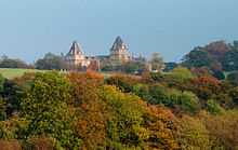
|
| The Bath House, Wynnstay | Ruabon | 6 July 1963 | SJ3053743422 52°59′01″N 3°02′10″W / 52.983640895694°N 3.0361026507414°W |
Bathhouse | 1628 |
| |
| Bettisfield Hall | Maelor South | 17 March 1953 | SJ4623835974 52°55′07″N 2°48′04″W / 52.918504663001°N 2.8010271502556°W |
Set back from the main road through Bettisfield, opposite the parish church. | 1639 |
| |
| The Bryn | Hanmer | 17 March 1953 | SJ4294441012 52°57′48″N 2°51′03″W / 52.963446939242°N 2.8508997244217°W |
Reached by a short farm road on the E side of Bryn Lane, approximately 1.6km W of Horseman's Green hamlet. | 1640 |
| |
| Willington Cross | Willington Worthenbury | 17 March 1953 | SJ4496642783 52°58′46″N 2°49′16″W / 52.979576948247°N 2.8211014518906°W |
Cross | Located off a lane from the cross-roads at Willington Cross, set in open fields and approached by a private drive. | 1642 |
|
| Church of St. Dunawd | Bangor-is-y-Coed | 16 November 1962 | SJ3887645404 53°00′09″N 2°54′44″W / 53.002473233122°N 2.9122873145561°W |
Church | Situated in a rectangular churchyard set back from High Street. | 1644 | 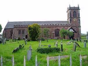
|
| Althrey Hall | Bangor-is-y-Coed | 16 November 1962 | SJ3790644093 52°59′26″N 2°55′35″W / 52.990578166673°N 2.9264872941332°W |
Hall | Situated c0.8km SW of Bangor Is-y-coed, reached from a drive running W from the B5069. | 1647 |
|
| The Ashes Farmhouse | Maelor South | 16 November 1962 | SJ4446636981 52°55′39″N 2°49′39″W / 52.927375233443°N 2.8275509299271°W |
Farmhouse | Reached by farm road on the NE side of a minor road between Breaden Heath and Penley, approximately 1.9km NW of Bettisfield church. | 1651 |
|
| Bettisfield Park, including attached garden walls | Hanmer | 16 November 1962 | SJ4606637500 52°55′56″N 2°48′14″W / 52.932203651968°N 2.8038390621656°W |
Country House | 1652 |
| |
| Church of St Chad | Hanmer | 16 November 1962 | SJ4546139734 52°57′08″N 2°48′48″W / 52.952222338451°N 2.8132153446208°W |
In a large churchyard and the most prominent building in the village, W of The Square and N of Hanmer Mere. | 1658 | _(St_Chad's_church).jpg)
| |
| Wern Farmhouse | Hanmer | 16 November 1962 | SJ4442640112 52°57′20″N 2°49′43″W / 52.955513459368°N 2.8286835977754°W |
Reached by farm road on the N side of the A539, approximately 1.1km W of Hanmer. | 1664 |
| |
| Iscoyd Park | Bronington | 16 November 1962 | SJ5044941977 52°58′22″N 2°44′22″W / 52.972868464637°N 2.7393245783793°W |
In its own grounds on the N side of the A525 at Redbrook, and E of a minor road to Higher Wych. | 1670 | .jpg)
| |
| Maes-y-Groes Farmhouse | Bronington | 16 November 1962 | SJ4981843045 52°58′57″N 2°44′56″W / 52.982409261331°N 2.7488860416668°W |
Farmhouse | On the W side of a minor road between Higher Wych and Redbrook, approximately 550m S of Higher Wych hamlet. | 1677 |
|
| Pen-y-bryn | Bronington | 16 November 1962 | SJ4855843616 52°59′15″N 2°46′04″W / 52.987421872237°N 2.7677422399009°W |
House | Reached by private road on the W side of a minor road and approximately 1.1km W of Higher Wych. | 1678 |
|
| Church of Saint Mary | Overton | 16 November 1962 | SJ3733241817 52°58′12″N 2°56′05″W / 52.970054541157°N 2.9345954308674°W |
Church | 1679 | 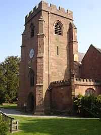
| |
| Knolton Hall, Knolton | Knolton, Overton-on-Dee | 16 November 1962 | SJ3526040573 52°57′31″N 2°57′55″W / 52.958626871245°N 2.9651941961241°W |
Hall | 1691 |
| |
| Llan-y-Cefn, Knolton | Knolton, Overton-on-Dee | 16 November 1962 | SJ3560141081 52°57′48″N 2°57′37″W / 52.963233881681°N 2.9602199180695°W |
1692 |
| ||
| Horseman's Green Farmhouse | Hanmer | 16 November 1962 | SJ4473541421 52°58′02″N 2°49′28″W / 52.967311113044°N 2.8243084080726°W |
Farmhouse | On the N side of the hamlet, set back on the W side of a minor road to the A525. | 1704 |
|
| Miners' Institute | Rhosllanerchrugog | 17 March 1987 | SJ2925246535 53°00′41″N 3°03′21″W / 53.011450960207°N 3.0559217218167°W |
Institute | An imposing public building above street level, up steps in a railed forecourt. | 1721 | 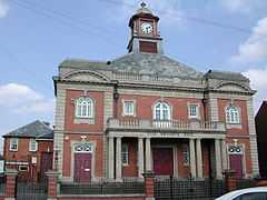
|
| Bryn-y-Grog Hall | Marchwiel | 19 July 1989 | SJ3484448398 53°01′44″N 2°58′23″W / 53.0289064601°N 2.9729659070588°W |
Hall | Situated c1km NW of Marchwiel in open countryside above the main road from Marchwiel to Wrexham. | 1727 |
|
| Former agent's house at site of Brymbo Ironworks | Brymbo | 25 October 1991 | SJ2947053475 53°04′26″N 3°03′15″W / 53.073853495682°N 3.0541941736404°W |
House | On the hillside to the S of the old ironworks site at Brymbo, adjacent to the rail line to Brymbo Colliery. Access by track and then steps from the main level of the ironworks. | 1731 | 
|
| Lower Berse Farmhouse, Berse Lane | Offa, Wrexham | 6 July 1963 | SJ3121950083 53°02′37″N 3°01′39″W / 53.043596021018°N 3.0273673729029°W |
Farmhouse | 1762 |
| |
| Tomb of Elihu Yale, west of Church of St. Giles, Church Street | Offa, Wrexham | 16 June 1980 | SJ3352150113 53°02′39″N 2°59′35″W / 53.044157368078°N 2.9930435348743°W |
Tomb | 1770 | 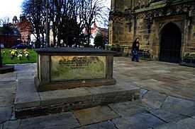
| |
| St. Giles' churchyard gates, Church Street | Offa, Wrexham | 30 May 1951 | SJ3353050168 53°02′41″N 2°59′35″W / 53.044652814519°N 2.9929206774915°W |
Gates | 1774 | 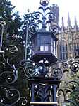
| |
| No 7, Church Street | Offa, Wrexham | 7 March 1974 | SJ3351350186 53°02′41″N 2°59′35″W / 53.044812476006°N 2.9931779272167°W |
Wine Bar | Chequers Wine Bar. Situated on west side of Church Street, in a prominent position on approach to the church. | 1776 | .jpg)
|
| Croesnewydd Hall, Rhyd Broughton Lane | Offa, Wrexham | 6 September 1952 | SJ3211150606 53°02′54″N 3°00′51″W / 53.04841078741°N 3.01417529074°W |
Hall | 1806 | 
| |
| No 7 Town Hill | Offa, Wrexham | 16 June 1980 | SJ3348050188 53°02′41″N 2°59′37″W / 53.044826339056°N 2.993670488874°W |
1817 |
| ||
| Penrhos Engine House | Brymbo | 12 January 1995 | SJ2856953225 53°04′17″N 3°04′03″W / 53.071486667438°N 3.0675844555162°W |
Engine House | On the N side of the road running on the W side of the former Steel Works site, W of Pen-Rhos Farm. | 14889 | 
|
| Wynnstay Kennels (including valeting house and attached courtyard buildings and boundary walls), Pen-y | Ruabon | 22 February 1995 | SJ3256042952 52°58′47″N 3°00′21″W / 52.979675541656°N 3.0058771259761°W |
Kennels | 15723 |
| |
| Vertical winding engine house at the former Wynnstay Colliery, Plas Madoc | Ruabon | 22 February 1995 | SJ2937243285 52°58′56″N 3°03′12″W / 52.982257019042°N 3.0534221520334°W |
Engine House | 15731 | 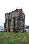
| |
| The Dairy at Wynnstay Hall, Wynnstay | Ruabon | 22 February 1995 | SJ3116142635 52°58′36″N 3°01′36″W / 52.97664822189°N 3.0266420918262°W |
Dairy | 15742 |
| |
| Wynnstay Column, Wynnstay | Ruabon | 22 February 1995 | SJ3056843065 52°58′50″N 3°02′08″W / 52.980436308194°N 3.0355642380233°W |
Column | 15746 |
| |
| Cascade, Wynnstay | Ruabon | 22 February 1995 | SJ3036443128 52°58′52″N 3°02′19″W / 52.980976015778°N 3.0386156255281°W |
Cascade | 15749 |
| |
| No 8 Church Street | Offa, Wrexham | 7 March 1974 | SJ3351250189 53°02′41″N 2°59′35″W / 53.044839314616°N 2.9931934607722°W |
Wine Bar | Chequers Wine Bar. Situated on west side of Church Street, in a prominent position on approach to the church. | 16477 |
|
| No 9 Church Street | Offa, Wrexham | 7 March 1974 | SJ3351050195 53°02′42″N 2°59′36″W / 53.04489299183°N 2.9932245279419°W |
Wine Bar | Chequers Wine Bar. Situated on west side of Church Street, in a prominent position on approach to the church. | 16478 |
|
| No 10 Church Street | Offa, Wrexham | 7 March 1974 | SJ3350850199 53°02′42″N 2°59′36″W / 53.044928693569°N 2.9932551818461°W |
16479 |
| ||
| Single Storey Building to SE of Octagonal Building at Bersham Ironworks Site | Bersham, Esclusham | 6 July 1963 | SJ3073349229 53°02′09″N 3°02′04″W / 53.035857733723°N 3.0344312867204°W |
Ironworks | In the centre of Bersham Village, towards the E end of the Ironworks site. | 16539 |
|
| Church of Saint Mary | Bersham, Esclusham | 12 August 1995 | SJ3052149281 53°02′11″N 3°02′15″W / 53.036297541098°N 3.0376034910736°W |
Church | In a wooded churchyard on the W side of Bersham village. | 16553 | 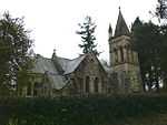
|
| Bersham Colliery No 2 Headframe | Bersham, Esclusham | 12 August 1995 | SJ3145948170 53°01′35″N 3°01′24″W / 53.026433496678°N 3.0233809637928°W |
Colliery headstock | On the SE side of the lane which leaves Wrexham Road opposite Church Street towards the W end of Rhostyllen. | 16567 | 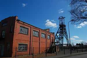
|
| Kitchen and attached laundries, bakehouse and scullery at Erddig | Marchwiel | 6 July 1963 | SJ3260048190 53°01′36″N 3°00′23″W / 53.02675847826°N 3.006376070205°W |
Kitchen block | Situated immediately to the S of Erddig and attached to the house by a late C19 linking block. | 17850 |
|
| Screen and gates closing the formal garden at Erddig | Marchwiel | 12 March 1996 | SJ3288948265 53°01′39″N 3°00′08″W / 53.027468956302°N 3.0020834854117°W |
Screen and Gates | Situated at the far end of the ornamental canal in the formal garden to the E of Erddig. | 17859 | 
|
| Cup and Saucer | Marchwiel | 12 March 1996 | SJ3245648401 53°01′43″N 3°00′31″W / 53.028636692244°N 3.0085669704594°W |
Hydraulic system | Situated c0.2m NW of Erddig to the W of the carriage drive. | 17869 | 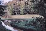
|
| War Memorial | Chirk | 29 July 1998 | SJ2905137755 52°55′57″N 3°03′25″W / 52.93251264056°N 3.0569893553674°W |
War memorial | The war memorial is set on a traffic island at the junction of Station Avenue with Church Street, near the centre of Chirk | 20202 | 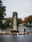
|
| Chirk Tunnel, including the N and S portals, and Chirk Basin | Chirk | 29 July 1998 | SJ2864337451 52°55′47″N 3°03′47″W / 52.929726201544°N 3.0629912422293°W |
Tunnel | The Chirk tunnel continues the canal N from Chirk basin at the N end of the aqueduct, and is reached by a path from Castle Road. | 20209 | 
|
| Railway Viaduct over River Ceiriog | Chirk | 29 July 1998 | SJ2866837285 52°55′42″N 3°03′45″W / 52.928237569279°N 3.0625828525182°W |
Viaduct | The viaduct crosses the valley parallel to Chirk Aqueduct, 550m SW of the Church at the centre of the village. | 20210 | 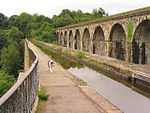
|
| Chirk Castle Stable Ranges | Chirk | 29 July 1998 | SJ2683238038 52°56′05″N 3°05′24″W / 52.93475774783°N 3.0900598512753°W |
Stables | The stables adjoin the castle to the S, forming two sides of the service courtyard | 20248 |
|
| Church of St John the Baptist | Maelor South | 17 October 2001 | SJ4613236021 52°55′08″N 2°48′09″W / 52.918916473787°N 2.8026112826043°W |
Church | In a large churchyard opposite Bettisfield Hall Farm, beyond the N end of the village. | 25804 | 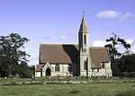
|
| Ceiriog Memorial Institute including retaining wall and railings | Llansantffraid Glyn Ceiriog | 7 August 2003 | SJ2021237848 52°55′56″N 3°11′19″W / 52.932105336864°N 3.1884845903495°W |
Institute | Located towards the S end of the High Street. The ground rises to the W and the building is slightly raised above road level. | 81286 |
|
| Fenn's Moss Peat Processing Works | Bronington | 20 October 2005 | SJ4780736656 52°55′29″N 2°46′40″W / 52.924789881821°N 2.7778044344245°W |
Peat works | An isolated building on the S side of a former railway, approximately 2.2km NE of Bettisfield. | 85456 |
|
| The Gelli | Bronington | 20 October 2005 | SJ4640943809 52°59′20″N 2°47′59″W / 52.988945500554°N 2.7997828254489°W |
Country house | Reached by private road on the N side of a minor road between Tallarn Green and Tybroughton, approximately 1.9km ESE of Tallarn Green church. | 85502 | 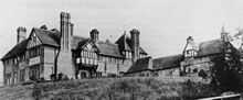
|
| Gates and gate piers at S entrance to Hanmer churchyard | Hanmer | 15 November 2005 | SJ4544239656 52°57′05″N 2°48′49″W / 52.951519313363°N 2.8134849518277°W |
Gates | On the S side of the churchyard opposite Hanmer Mere. | 86936 | 
|
| Hanmer churchyard cross | Hanmer | 15 November 2005 | SJ4546539721 52°57′08″N 2°48′47″W / 52.952105897817°N 2.8131536224756°W |
Cross | On the S side of the nave, and immediately S of the footpath leading from porch to The Square. | 86940 |
|
| Hanmer war memorial | Hanmer | 15 November 2005 | SJ4542339661 52°57′06″N 2°48′50″W / 52.951562318182°N 2.8137685576025°W |
Set into the S churchyard wall W of the main entrance and opposite Hanmer Mere. | 86941 |
| |
| The Stables at Bettisfield Park | Hanmer | 16 November 1962 | SJ4607937592 52°55′59″N 2°48′13″W / 52.933031890816°N 2.8036610020738°W |
Stables | On the N side of the house and reached by a separate entrance from New Road. | 86950 | |
Notes
- ↑ Sometimes known as OSGB36, the grid reference is based on the British national grid reference system used by the Ordnance Survey.
- ↑ The "HB Number" is a unique number assigned to each listed building by Cadw.
See also
References
- ↑ [http://cadw .wales.gov.uk/historicenvironment/protection/buildconservation/;jsessionid=D3D0B3A0E04ED44C34056CF232E151C2?lang=en "Buildings & Conservation Areas"]. Cadw. Retrieved 18 June 2013.
- ↑ "Planning (Listed Buildings and Conservation Areas) Act 1990". The National Archives. Retrieved 18 June 2013.
External links
![]() Media related to Grade II* listed buildings in Wrexham County Borough at Wikimedia Commons
Media related to Grade II* listed buildings in Wrexham County Borough at Wikimedia Commons
| ||||||||||||||||||||||||||||||||||||