Grade II* listed buildings in Torfaen
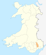
Torfaen shown within Wales
In the United Kingdom, the term listed building refers to a building or other structure officially designated as being of special architectural, historical, or cultural significance; Grade II* structures are those considered to be "particularly important buildings of more than special interest".[1] Listing was begun by a provision in the Town and Country Planning Act 1947. Once listed, strict limitations are imposed on the modifications allowed to a building's structure or fittings. In Wales, the authority for listing under the Planning (Listed Buildings and Conservation Areas) Act 1990[2] rests with Cadw.
Buildings
| Name | Location | Date Listed | Grid Ref.[note 1] Geo-coordinates |
Function | Notes | HB No[note 2] | Image |
|---|---|---|---|---|---|---|---|
| Church of Saint Peter, Henllys | Henllys | 3 January 1963 | ST2677191038 51°36′48″N 3°03′32″W / 51.613413600564°N 3.0589896056216°W |
Situated in a rural location some 2.8km south of the old village at Henllys. | 2915 | 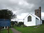
| |
| The Shell Grotto, Pontypool Park | Trevethin | 7 February 1962 | SO2933401028 51°42′13″N 3°01′26″W / 51.703549656691°N 3.0240035079152°W |
At the summit of the hill in the north east corner of Pontypool Park. | 3112 | 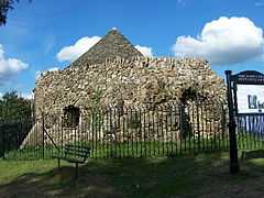
| |
| Church of St Michael and All Angels | New Inn | 7 February 1962 | SO3013301101 51°42′16″N 3°00′45″W / 51.704306162226°N 3.0124578878227°W |
Situated at the bottom of the 'Pitch' next to the Horse & Jockey public house. | 3114 | 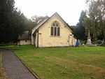
| |
| Crane Street Baptist Church | Pontymoile | 7 February 1962 | SO2810400928 51°42′09″N 3°02′30″W / 51.702494130951°N 3.0417788876368°W |
In Pontypool town centre backing onto Pontypool Market. | 3118 | 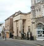
| |
| Pontypool Museum | Pontymoile | 7 February 1962 | SO2826701058 51°42′13″N 3°02′22″W / 51.703683688355°N 3.0394473961088°W |
To the north of Pontypool town centre and immediately to the west of Pontypool Park house, now St Alban's RC School. | 3120 | 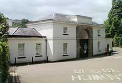
| |
| St Michael's Church, Llantarnam | Llantarnam | 5 January 1951 | ST3069793155 51°37′59″N 3°00′10″W / 51.632943203818°N 3.0027186618828°W |
In a churchyard on the SE side of Newport Road some 140m SW of its junction with Llantarnam Road. | 3121 | 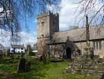
| |
| Pentre-Bach and attached outbuildings | Llantarnam | 6 June 1962 | ST2855492075 51°37′23″N 3°02′00″W / 51.622965601765°N 3.03345551293°W |
Reached via a track N off Pentre Lane on the W side of Llantarnam. | 3126 | 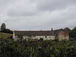
| |
| 1 Forge Row | Abersychan | 5 September 1973 | SO2703906558 51°45′11″N 3°03′30″W / 51.752967660505°N 3.0583688672291°W |
Situated at the base of a steep hillside, on the east bank of Afon Lwyd about 40m south of Cwmavon House. Rubble forecourt wall. | 3133 | 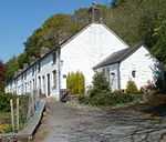
| |
| Llanyrafon | Llanyrafon | 3 April 1952 | ST3032894587 51°38′45″N 3°00′30″W / 51.645770987742°N 3.0083347975447°W |
3140 | 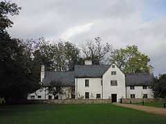
| ||
| Church of All Saints, Ponthir | Ponthir | 22 January 1981 | ST3203793628 51°38′14″N 2°59′00″W / 51.637359254596°N 2.9834529163056°W |
In a rural location on the NE side of Llanfrechfa some 300m E of the junction of Church Road and the B4236. | 3142 | 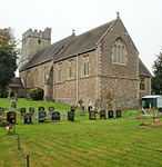
| |
| Former St Peter's School, Blaenavon | Blaenavon | 4 July 1989 | SO2506408825 51°46′23″N 3°05′15″W / 51.773085442618°N 3.0874642420139°W |
Situated half way up Church Road immediately downhill from the other St Peter's school buildings and with south-east front facing the churchyard. Below the level of the road and set back behind iron railings on dwarf walls. | 3150 | 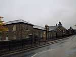
| |
| Former British Ironworks office and foundry quadrangle | Abersychan | 13 September 1994 | SO2572203624 51°43′35″N 3°04′37″W / 51.726419055873°N 3.0768168799865°W |
The most prominent building in the area of the former British Ironworks, about 1000m south west of St Thomas's Church, Talywain. | 14870 | 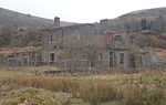
| |
| St Peter's Church, Blaenavon | Blaenavon | 2 September 1995 | SO2512408778 51°46′22″N 3°05′12″W / 51.772670985343°N 3.0865846733988°W |
Situated at the bottom of Church Road, on the south side, set back behind railings. | 15273 | 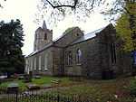
| |
| Pit head building, headframe and tram circuit, Big Pit National Coal Museum | Blaenavon | 2 September 1995 | SO2389108762 51°46′20″N 3°06′16″W / 51.772360537655°N 3.1044474725462°W |
Situated at the north-east edge of the site. | 15280 | 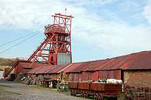
| |
| Miners' baths and canteen, Big Pit National Coal Museum | Blaenavon | 2 September 1995 | SO2372008733 51°46′19″N 3°06′25″W / 51.772076524304°N 3.1069188810336°W |
Situated at the top of the site to the south-west. | 15290 | 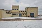
| |
| Entrance Gates to Pontypool Park | Trevethin | 29 May 1997 | SO2905900518 51°41′56″N 3°01′40″W / 51.698930143898°N 3.0278783859267°W |
The entrance on to the main drive from Pontymoel at the very south east extremity of Pontypool Park, at a bend in the road. | 18466 | 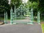
| |
| 2 Forge Row | Abersychan | 5 September 1973 | SO2704006547 51°45′10″N 3°03′30″W / 51.752868906223°N 3.0583520711291°W |
Situated at the base of a steep hillside, on the east bank of Afon Lwyd about 40m south of Cwmavon House. Rubble forecourt wall. | 18586 | 
| |
| 3 Forge Row | Abersychan | 5 September 1973 | SO2704106538 51°45′10″N 3°03′30″W / 51.752788130991°N 3.058335695476°W |
Situated at the base of a steep hillside, on the east bank of Afon Lwyd about 40m south of Cwmavon House. Rubble forecourt wall. | 18587 |
| |
| 4 Forge Row | Abersychan | 5 September 1973 | SO2704206529 51°45′10″N 3°03′30″W / 51.752707355756°N 3.0583193198834°W |
Situated at the base of a steep hillside, on the east bank of Afon Lwyd about 40m south of Cwmavon House. Rubble forecourt wall. | 18588 |
| |
| 5 Forge Row | Abersychan | 5 September 1973 | SO2704206520 51°45′09″N 3°03′30″W / 51.752626450012°N 3.0583174282541°W |
Situated at the base of a steep hillside, on the east bank of Afon Lwyd about 40m south of Cwmavon House. Rubble forecourt wall. | 18589 |
| |
| 6 Forge Row | Abersychan | 5 September 1973 | SO2704306510 51°45′09″N 3°03′30″W / 51.752536685243°N 3.0583008425801°W |
Situated at the base of a steep hillside, on the east bank of Afon Lwyd about 40m south of Cwmavon House. Rubble forecourt wall. | 18590 |
| |
| Llantarnam Abbey | Llantarnam | 6 June 1962 | ST3115192913 51°37′51″N 2°59′46″W / 51.630823511669°N 2.9961124952884°W |
In extensive grounds on the E side of Llantarnam. Approached along a drive E from Newport Road under the Cwmbran By-pass. | 85246 | .jpg)
| |
| Former Nylon Spinners Factory | New Inn | 17 October 2005 | SO3084902365 51°42′57″N 3°00′08″W / 51.715758083247°N 3.0023494964661°W |
A prominent landscape feature, at the south end of the Mamhilad Park Industrial Estate. | 85438 | 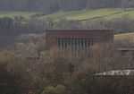 |
Notes
- ↑ Sometimes known as OSGB36, the grid reference is based on the British national grid reference system used by the Ordnance Survey.
- ↑ The "HB Number" is a unique number assigned to each listed building by Cadw.
See also
- Listed buildings in Wales
- Grade II* listed buildings in Monmouthshire
- Grade II* listed buildings in Newport
- Grade II* listed buildings in Caerphilly County Borough
- Grade II* listed buildings in Blaenau Gwent
- Grade I listed buildings in Torfaen
- Scheduled Monuments in Torfaen
References
- ↑ "Buildings & Conservation Areas". Cadw. Retrieved 18 June 2013.
- ↑ "Planning (Listed Buildings and Conservation Areas) Act 1990". The National Archives. Retrieved 18 June 2013.
External links
![]() Media related to Grade II* listed buildings in Torfaen at Wikimedia Commons
Media related to Grade II* listed buildings in Torfaen at Wikimedia Commons
| |||||||||||||||||||||||||||||||||