| Name |
Location |
Type |
Completed | Date designated |
Grid ref.
Geo-coordinates |
Entry number | Image |
|
|
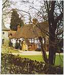
| Albury Park |
Albury Park, Albury |
Country house |
16th century |
01967-06-14-000014 June 1967 |
TQ0639047700
51°13′07″N 0°28′41″W / 51.218596°N 0.478035°W / 51.218596; -0.478035 (Albury Park) |
1029565 |
More images
|
| Bath House and Terrace to Albury House, Tunnel Entrance Bath House and Terraces |
Albury Park, Albury |
Bath House |
1667-1676 |
01967-06-14-000014 June 1967 |
TQ0651447964
51°13′15″N 0°28′34″W / 51.220946°N 0.476182°W / 51.220946; -0.476182 (Bath House and Terrace to Albury House, Tunnel Entrance Bath House and Terraces) |
1029566 |

|
| Catholic Apostolic Church and Chapterhouse |
Albury Park, Albury |
Church |
1840 |
01967-06-14-000014 June 1967 |
TQ0603148144
51°13′22″N 0°28′59″W / 51.222654°N 0.483043°W / 51.222654; -0.483043 (Catholic Apostolic Church and Chapterhouse) |
1029568 |
More images
|
| 8 and 9 Littleton Lane |
Artington |
House |
17th century |
01967-06-14-000014 June 1967 |
SU9815547331
51°13′00″N 0°35′46″W / 51.216752°N 0.59601°W / 51.216752; -0.59601 (8 and 9 Littleton Lane) |
1188281 |
|
| Church of St Peter |
Ash |
Church |
12th century |
01967-06-14-000014 June 1967 |
SU8974750778
51°14′57″N 0°42′56″W / 51.249122°N 0.715498°W / 51.249122; -0.715498 (Church of St Peter) |
1029647 |
More images
|
| Watts Gallery |
Compton |
House/Art Gallery |
1903-4 |
01975-06-04-00004 June 1975 |
SU9584947807
51°13′17″N 0°37′44″W / 51.221423°N 0.628889°W / 51.221423; -0.628889 (Watts Gallery) |
1188403 |
More images
|
| Church of St Martin |
East Horsley |
Church |
12th century |
01967-06-14-000014 June 1967 |
TQ0952452811
51°15′50″N 0°25′54″W / 51.263944°N 0.431617°W / 51.263944; -0.431617 (Church of St Martin) |
1377815 |
More images
|
| Horsley Towers |
East Horsley |
Country house |
1820-1829 |
01967-06-14-000014 June 1967 |
TQ0982552982
51°15′56″N 0°25′38″W / 51.265423°N 0.427252°W / 51.265423; -0.427252 (Horsley Towers) |
1294810 |
|
| Church of St Lawrence |
Effingham |
Church |
12th century |
01967-06-14-000014 June 1967 |
TQ1182953664
51°16′16″N 0°23′54″W / 51.271164°N 0.398328°W / 51.271164; -0.398328 (Church of St Lawrence) |
1294793 |
More images
|
| Castle Arch |
Guildford |
House |
1672 |
01953-05-01-00001 May 1953 |
SU9969549249
51°14′01″N 0°34′24″W / 51.233727°N 0.573434°W / 51.233727; -0.573434 (Castle Arch) |
1189846 |
|
| Cathedral Church of the Holy Spirit |
Guildford |
Anglican Cathedral |
1936-1939 |
01981-01-16-000016 January 1981 |
SU9853850044
51°14′28″N 0°35′23″W / 51.241074°N 0.589783°W / 51.241074; -0.589783 (Cathedral Church of the Holy Spirit) |
1377883 |
More images
|
| Church of St John the Evangelist |
Guildford |
Church |
1858 |
01953-05-01-00001 May 1953 |
SU9982150725
51°14′49″N 0°34′16″W / 51.246973°N 0.571219°W / 51.246973; -0.571219 (Church of St John the Evangelist) |
1294008 |
More images
|
| Church of St Nicholas |
Guildford |
Church |
1875 |
01953-05-01-00001 May 1953 |
SU9941549346
51°14′05″N 0°34′39″W / 51.234648°N 0.577417°W / 51.234648; -0.577417 (Church of St Nicholas) |
1029291 |
More images
|
| Lloyds Bank |
Guildford |
Bank |
1765 |
01953-05-01-00001 May 1953 |
SU9979649503
51°14′10″N 0°34′19″W / 51.235993°N 0.571918°W / 51.235993; -0.571918 (Lloyds Bank) |
1029287 |
|
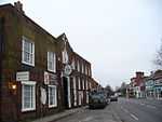
| The Angel Hotel |
Guildford |
House |
19th century |
01953-05-01-00001 May 1953 |
SU9966349457
51°14′08″N 0°34′26″W / 51.235602°N 0.573835°W / 51.235602; -0.573835 (The Angel Hotel) |
1029282 |
|
| The Treadwheel Crane |
Guildford |
Treadwheel Crane |
Late C17/C18 |
01953-05-01-00001 May 1953 |
SU9943449434
51°14′08″N 0°34′38″W / 51.235436°N 0.57712°W / 51.235436; -0.57712 (The Treadwheel Crane) |
1377866 |
|
72, 74, 76 and 78 High Street
[one, 1803-built two-bay mid-terrace
with 13th century undercroft.] |
Guildford |
House |
1803 |
01953-05-01-00001 May 1953 |
SU9967649432
51°14′07″N 0°34′25″W / 51.235375°N 0.573656°W / 51.235375; -0.573656 (72, 74, 76 and 78 High Street
[one, 1803-built two-bay mid-terrace
with 13th century undercroft.)] |
1180242 |
]
|
| 6 Quarry Street |
Guildford |
House |
Late C17/Early 18th century |
01953-05-01-00001 May 1953 |
SU9964549300
51°14′03″N 0°34′27″W / 51.234194°N 0.574136°W / 51.234194; -0.574136 (6 Quarry Street) |
1294017 |
|
| 8 and 8a Quarry Street |
Guildford |
House |
Late C17/Early 18th century |
01953-05-01-00001 May 1953 |
SU9964849293
51°14′03″N 0°34′27″W / 51.234131°N 0.574095°W / 51.234131; -0.574095 (8 and 8a Quarry Street) |
1029224 |
|
| 13 Quarry Street |
Guildford |
House |
Late C13/C14 |
01953-05-01-00001 May 1953 |
SU9966149262
51°14′02″N 0°34′26″W / 51.23385°N 0.573918°W / 51.23385; -0.573918 (13 Quarry Street) |
1294022 |
|
| 55 Quarry Street |
Guildford |
House |
Pre 18th century |
01953-05-01-00001 May 1953 |
SU9965649328
51°14′04″N 0°34′26″W / 51.234444°N 0.573971°W / 51.234444; -0.573971 (55 Quarry Street) |
1029216 |
|
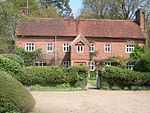
| Norney Grange |
Norney, Shackleford |
House |
1897 |
01985-05-21-000021 May 1985 |
SU9384044906
51°11′44″N 0°39′30″W / 51.195678°N 0.658406°W / 51.195678; -0.658406 (Norney Grange) |
1029515 |
|
| Stables to Ockham Park House |
Ockham |
Flats |
Early 18th century |
01967-06-14-000014 June 1967 |
TQ0653856551
51°17′53″N 0°28′24″W / 51.298127°N 0.473284°W / 51.298127; -0.473284 (Stables to Ockham Park House) |
1188468 |
|
| Church of St Michael and All Angels |
Pirbright |
Church |
Rebuilt 1784 |
01967-06-14-000014 June 1967 |
SU9423055916
51°17′41″N 0°39′00″W / 51.294586°N 0.649932°W / 51.294586; -0.649932 (Church of St Michael and All Angels) |
1377714 |
More images
|
| Church of St John the Baptist |
Puttenham |
Church |
12th century |
01967-06-14-000014 June 1967 |
SU9330847861
51°13′20″N 0°39′55″W / 51.222329°N 0.66525°W / 51.222329; -0.66525 (Church of St John the Baptist) |
1029601 |
More images
|
| Puttenham Priory |
Puttenham |
Country house |
1762 |
01957-02-19-000019 February 1957 |
SU9333447818
51°13′19″N 0°39′54″W / 51.221938°N 0.664889°W / 51.221938; -0.664889 (Puttenham Priory) |
1294505 |
|
| Church of St Mary the Virgin |
Ripley |
Church |
C20 |
01967-06-14-000014 June 1967 |
TQ0512356634
51°17′57″N 0°29′37″W / 51.299136°N 0.493548°W / 51.299136; -0.493548 (Church of St Mary the Virgin) |
1188603 |
More images
|
| The Talbot |
Ripley |
Restaurant |
16th century |
01967-06-14-000014 June 1967 |
TQ0541456877
51°18′05″N 0°29′21″W / 51.301266°N 0.489304°W / 51.301266; -0.489304 (The Talbot) |
1029372 |
|
| Church of St Mary |
Send |
Church |
c. 1240 |
01967-06-14-000014 June 1967 |
TQ0186954343
51°16′45″N 0°32′27″W / 51.279133°N 0.540858°W / 51.279133; -0.540858 (Church of St Mary) |
1188756 |
More images
|
| Unstead Bridge |
Shalford |
Bridge |
13th century |
01967-06-14-000014 June 1967 |
SU9931145435
51°11′58″N 0°34′48″W / 51.199509°N 0.579988°W / 51.199509; -0.579988 (Unstead Bridge) |
1029507 |
|
| Shalford Mill |
Shalford |
Watermill |
Early 18th century |
01967-06-14-000014 June 1967 |
TQ0010647635
51°13′09″N 0°34′05″W / 51.219147°N 0.568°W / 51.219147; -0.568 (Shalford Mill) |
1294360 |
|
| Unstead Manor |
Shalford |
Country house |
16th century |
01967-06-14-000014 June 1967 |
SU9940945442
51°11′58″N 0°34′43″W / 51.199555°N 0.578584°W / 51.199555; -0.578584 (Unstead Manor) |
1294317 |
|
| Fulvens House |
Shere |
House |
c. 1620 |
01967-06-14-000014 June 1967 |
TQ0977046413
51°12′23″N 0°25′48″W / 51.206389°N 0.430051°W / 51.206389; -0.430051 (Fulvens House) |
1294281 |
|
| Old Hatch Farm House |
Shere |
House |
Late 19th century |
01967-06-14-000014 June 1967 |
TQ0939447627
51°13′03″N 0°26′06″W / 51.217373°N 0.435062°W / 51.217373; -0.435062 (Old Hatch Farm House) |
1377801 |
|
| Usherwood |
Shere |
Bungalow |
Built 1934-36 |
02008-10-17-000017 October 2008 |
TQ0997645397
51°11′50″N 0°25′39″W / 51.197217°N 0.427415°W / 51.197217; -0.427415 (Usherwood) |
1392952 |
|
| Barn, 80 Yards West of Church of St Bartholomew |
Wanborough |
Barn |
17th century |
01967-06-14-000014 June 1967 |
SU9342948893
51°13′54″N 0°39′48″W / 51.231586°N 0.663249°W / 51.231586; -0.663249 (Barn, 80 Yards West of Church of St Bartholomew) |
1029613 |
|
| Greyfriars |
Wanborough |
House |
1896 |
01984-12-13-000013 December 1984 |
SU9459748313
51°13′34″N 0°38′48″W / 51.22618°N 0.646678°W / 51.22618; -0.646678 (Greyfriars) |
1029612 |
|
| Church of St Peter and St Paul |
West Clandon |
Church |
Late 12th century |
01967-06-14-000014 June 1967 |
TQ0441851250
51°15′03″N 0°30′19″W / 51.25087°N 0.505227°W / 51.25087; -0.505227 (Church of St Peter and St Paul) |
1029360 |
More images
|
| Lodges and Gates to Clandon Park House |
West Clandon |
Gate |
Early 18th century |
01967-06-14-000014 June 1967 |
TQ0305950832
51°14′50″N 0°31′29″W / 51.247359°N 0.524813°W / 51.247359; -0.524813 (Lodges and Gates to Clandon Park House) |
1188805 |
|
| Foxwarren Park |
Wisley |
Country House |
1860 |
01981-09-22-000022 September 1981 |
TQ0794259972
51°19′43″N 0°27′08″W / 51.328612°N 0.452119°W / 51.328612; -0.452119 (Foxwarren Park) |
1189110 |
|
| Littlefield Manor |
Worplesdon |
House |
Late 17th century |
01967-06-14-000014 June 1967 |
SU9587152099
51°15′36″N 0°37′39″W / 51.260001°N 0.627427°W / 51.260001; -0.627427 (Littlefield Manor) |
1191554 |
|

_(9).JPG)
_(2).jpg)

_(3).JPG)

_(2).JPG)

_(May_2014)_(1).JPG)
_(1).jpg)
.JPG)
.jpg)


_(9).JPG)
_(4).jpg)

_(5).JPG)


.jpg)
_(2).JPG)

.jpg)