Grade II* listed buildings in Carmarthenshire
In the United Kingdom, the term listed building refers to a building or other structure officially designated as being of special architectural, historical, or cultural significance; Grade II* structures are those considered to be "particularly important buildings of more than special interest".[1] Listing was begun by a provision in the Town and Country Planning Act 1947. Once listed, strict limitations are imposed on the modifications allowed to a building's structure or fittings. In Wales, the authority for listing under the Planning (Listed Buildings and Conservation Areas) Act 1990[2] rests with Cadw.
Buildings
| Name | Location | Date Listed | Grid Ref.[note 1] Geo-coordinates |
Function | Notes | HB No[note 2] | Image |
|---|---|---|---|---|---|---|---|
| Cenarth Bridge | Cenarth | 23 June 1967 | SN2691641580 52°02′44″N 4°31′31″W / 52.045510603562°N 4.5253346744034°W |
Bridge | Crosses Afon Teifi between Cardigan and Newcastle Emlyn. Also in Ceredigion. | 9374 | 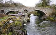
|
| Church of St Luke, Llanllwni | Llanllwni | 23 June 1967 | SN4734441299 52°02′56″N 4°13′39″W / 52.04900496°N 4.2275870860976°W |
Church | In an isolated position away from Llanllwni village and on an elevated site directly above Afon Teifi. | 9378 | 
|
| Pont Cothi | Llanfihangel Rhos-y-Corn | 7 August 1966 | SN5847333584 51°58′58″N 4°03′44″W / 51.982647858451°N 4.0622209383088°W |
Bridge | Spanning the Afon Cothi in the centre of the village and carrying a minor road immediately S of its junction with the B4310. | 9380 |
|
| Paxton's Tower | Llanarthney | 12 March 1951 | SN5409719147 51°51′06″N 4°07′11″W / 51.851802258629°N 4.1197734847521°W |
Tower | On the summit of a high hill 1km SE of Llanarthney village, making an impressive and conspicuous landmark for miles around. | 9384 | 
|
| Plas Llanstephan | Llansteffan | 12 March 1951 | SN3492110466 51°46′06″N 4°23′38″W / 51.768465191051°N 4.3938043643346°W |
Country house | At the end of a private access road leading S from Llansteffan village. | 9385 | 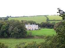
|
| Cwmgwili | Bronwydd | 30 November 1966 | SN4234823255 51°53′08″N 4°17′32″W / 51.885504785975°N 4.2920916404795°W |
House | Set in its own grounds approximately 2.5km NW of Abergwili. | 9387 |
|
| Church of Saint Cynwyl, Cynwyl Elfed | Cynwyl Elfed | 30 November 1966 | SN3737227507 51°55′20″N 4°21′59″W / 51.922268108283°N 4.366334817536°W |
Church | Situated near the centre of Cynwyl Elfed village NE of Pont Cynwyl just off the A484. | 9388 | 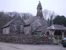
|
| Church of St David, Llanarthney (also known as Church of St Arthneu or St Arthney). | Llanarthney | 30 November 1966 | SN5344220262 51°51′42″N 4°07′47″W / 51.861648171091°N 4.1297495210524°W |
Church | In centre of the village of Llanarthney. Stone-walled graveyard with lychgate [separately listed]. Graveyard extended to W. Numerous tombstones of a locally favoured tapering obelisk type; several enclosures with cast-iron railings. | 9390 | .jpg)
|
| Pont Llandeilo-yr-ynys | Llanarthney | 30 November 1966 | SN4931820280 51°51′39″N 4°11′23″W / 51.860708827894°N 4.1896001946511°W |
Bridge | Across River Towy 8km east of Carmarthen. Also in Llanegwad. | 9391 | 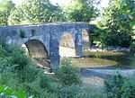
|
| Capel Bigawdin | Llanddarog | 30 November 1966 | SN5115314712 51°48′40″N 4°09′38″W / 51.811176739458°N 4.1605761997521°W |
Chapel | Attached to a field wall S of Wern-las Farm, approximately 2km SE of Llanddarog village. | 9395 |
|
| Church of St Cyndeyrn, Llangyndeyrn | Llangyndeyrn | 30 November 1966 | SN4562113985 51°48′11″N 4°14′26″W / 51.80314123722°N 4.2404340655234°W |
Church | In a round churchyard in the centre of the village. | 9399 | 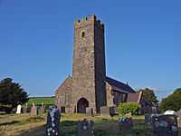
|
| Church of Saint Cynin, Llangynin | Llangynin | 30 November 1966 | SN2539618043 51°50′01″N 4°32′08″W / 51.833625534189°N 4.5355208296816°W |
Church | Situated in an isolated position on a minor road some 2km S of the centre of the village of Llangynin. | 9401 |
|
| Church of St Ystyffan, Llansteffan | Llansteffan | 30 November 1966 | SN3500910708 51°46′14″N 4°23′34″W / 51.770665130334°N 4.3926452468704°W |
Church | Within a stone walled cemetery, on the SW corner of the junction of High Street and Church Street. | 9404 | .jpg)
|
| Vale View, Llansteffan | Llansteffan | 30 November 1966 | SN3493610704 51°46′14″N 4°23′37″W / 51.770607619371°N 4.3937003483724°W |
House | Set slightly back from the street, on the S side of the road, within a small railed forecourt, immediately W of Brook Cottages. | 9406 |
|
| Parish Church of St Mary Magdalene, St Clears | St Clears | 30 November 1966 | SN2815115739 51°48′50″N 4°29′40″W / 51.813786986612°N 4.4944333496493°W |
Church | Situated within a cemetery behind the street, reached via a lych-gate opposite the Town Hall. | 9409 | |
| Rhydarwen | Llanarthney | 13 December 1971 | SN5588019469 51°51′19″N 4°05′39″W / 51.855159697407°N 4.0940392716704°W |
At north of the B4300, 2?km east of the village of Llanarthney. Small farmyard at west. Stone wall facing the farmyard and to the roadside. | 9417 |
| |
| Carmarthen Guildhall | Carmarthen | 18 August 1954 | SN4121220020 51°51′22″N 4°18′26″W / 51.856119725629°N 4.3070947910891°W |
Guildhall | Situated at upper end of the square. | 9450 | 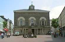
|
| No 51 King Street including near-detached rear wing | Carmarthen | 19 May 1981 | SN4134220111 51°51′25″N 4°18′19″W / 51.856974301465°N 4.3052505761105°W |
Situated opposite Post Office. | 9471 | 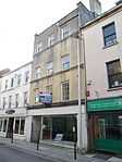
| |
| Capel Heol Awst | Carmarthen | 19 May 1981 | SN4090620031 51°51′22″N 4°18′42″W / 51.856131172848°N 4.3115392366242°W |
Chapel | Situated set back in railed forecourt roughly midway along street. | 9488 | .jpg)
|
| Church of St Mary, Llanllwch | Llanllwch | 19 May 1981 | SN3858318782 51°50′39″N 4°20′41″W / 51.844242175599°N 4.3446566442511°W |
Church | Situated in centre of Llanllwch village. | 9495 | 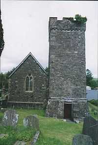
|
| 2 Quay Street | Carmarthen | 18 August 1954 | SN4120819988 51°51′21″N 4°18′26″W / 51.85583110962°N 4.3071381106852°W |
House | Situated some 5m SW of junction with St Mary's Street. | 9556 | 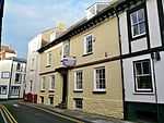
|
| Ty Gelli Aur/Golden Grove House, with steps and railings | Carmarthen | 18 August 1954 | SN4117319928 51°51′19″N 4°18′27″W / 51.855282109037°N 4.3076182909129°W |
House | Situated 15m NE of junction with Little Bridge Street. | 9561 | 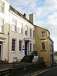
|
| Parish church of St Martin, Laugharne | Laugharne, Laugharne Township | 30 November 1966 | SN3021311437 51°46′33″N 4°27′45″W / 51.775775538091°N 4.4624427020803°W |
Church | 9623 | 
| |
| Great House, Laugharne | Laugharne Township | 30 November 1966 | SN3015011061 51°46′21″N 4°27′47″W / 51.772378876854°N 4.4631709573224°W |
House | 9650 |
| |
| Castle House, Laugharne | Laugharne Township | 30 November 1966 | SN3021210813 51°46′13″N 4°27′44″W / 51.770170027813°N 4.4621519360305°W |
House | Pink-painted stucco walls. Market Street, opposite Town Hall | 9657 | 
|
| Laugharne town hall | Laugharne Township | 12 March 1951 | SN3020610838 51°46′13″N 4°27′44″W / 51.770392770583°N 4.4622510356178°W |
Town Hall | 9659 | 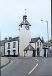
| |
| Newcastle Emlyn Bridge | Newcastle Emlyn | 21 September 1964 | SN3091340861 52°02′25″N 4°28′00″W / 52.040289510935°N 4.4667536009472°W |
Bridge | 9686 | 
| |
| The Bunch of Grapes Inn | Newcastle Emlyn | 8 May 1991 | SN3087440748 52°02′21″N 4°28′02″W / 52.039262587104°N 4.4672657398614°W |
Inn | 9692 | 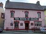
| |
| Felin Wen (White Mill) | Abergwili | 6 April 1974 | SN4625521442 51°52′13″N 4°14′04″W / 51.87031069061°N 4.2345621721395°W |
Mill | On the S side of the road through White Mill hamlet, opposite a junction with a minor road to Capel Gwyn. | 9720 |
|
| Cenarth Mill | Cenarth | 1 August 1975 | SN2700941575 52°02′44″N 4°31′26″W / 52.045494808549°N 4.5239774371234°W |
Mill | Situated on riverside, down track some 100m NE of the White Hart Inn. | 9723 | 
|
| Gilfach y Berthog | Abergwili | 24 September 1991 | SN4813222958 51°53′04″N 4°12′29″W / 51.884446168733°N 4.2079881131739°W |
Approximately 2.5km NE of Whitemill, reached by farm road on the N side of a minor road 0.75km W of Llanfihangel-uwch-gwili. | 9738 |
| |
| English Baptist Church, Carmarthen | Carmarthen | 19 May 1981 | SN4106720098 51°51′24″N 4°18′33″W / 51.856779064039°N 4.3092343134671°W |
Church | Situated set back from the street in paved forecourt, between Nos 7 and 8. | 9741 | 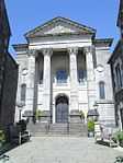
|
| Capel Y Graig including attached schoolroom and forecourt railings | Trelech | 16 December 1993 | SN2817830337 51°56′42″N 4°30′05″W / 51.944918882524°N 4.5013132712795°W |
Chapel | Situated just W of the road junction in the centre of Trelech village. | 9758 | 
|
| Derwydd Mansion | Llandybie | 26 November 1951 | SN6126117836 51°50′31″N 4°00′55″W / 51.841853391024°N 4.0153043514728°W |
In private grounds about 2km north-north-west of Llandybie village. | 10903 |
| |
| Pantycelyn Farmhouse | Llanfair ar y Bryn | 26 November 1951 | SN8199935402 52°00′16″N 3°43′14″W / 52.004492831684°N 3.7204635314481°W |
Situated down a lane some 300m E of the centre of Pentre-ty-gwyn village. | 10905 |
| |
| Henllys | Cilycwm | 7 August 1966 | SN7551036626 52°00′51″N 3°48′55″W / 52.014071772772°N 3.8153910488824°W |
House | Situated about 1km NNW of Dolauhirion Bridge, approached from N via drive off road to Siloh some 250m W of junction with road to Cilycwm. | 10907 | 
|
| Parish church of St Cynwyl, Caeo | Cynwyl Gaeo | 7 August 1966 | SN6750739907 52°02′30″N 3°56′00″W / 52.041696368439°N 3.9332066433071°W |
Church | 10908 | .jpg)
| |
| Cwrt Bryn y Beirdd | Dyffryn Cennen | 7 August 1966 | SN6630718093 51°50′43″N 3°56′32″W / 51.845396461154°N 3.9422038111173°W |
Situated to SE of Trap, reached by drive running E from crossroads about 1 km S of Trap. | 10909 |
| |
| Church of St Simon and St Jude, Llanddeusant | Llanddeusant | 7 August 1966 | SN7769424533 51°54′21″N 3°46′45″W / 51.905886020171°N 3.7792747790155°W |
Church | Situated on ridge above upper Sawdde valley some 2.5 km E of Twynllanan on road to Llyn y Fan Fach. | 10914 | .jpg)
|
| Church of St Tybie, Llandybie | Llandybie | 7 August 1966 | SN6182315550 51°49′17″N 4°00′22″W / 51.821452407457°N 4.0062385591312°W |
Church | At the centre of Llandybie village. Large stone-walled graveyard to north side (recent parts walled in concrete blocks). High wall with steps and iron gates from the street at west and south; stile beside south gate. Church House at south-east. | 10915 | 
|
| Cil-yr-ychen Lime Kilns | Llandybie | 7 August 1966 | SN6166416761 51°49′56″N 4°00′33″W / 51.832294308889°N 4.0090282625928°W |
Prominently sited 200m to the west of Llandeilo Road, about 1? km north of Llandybie village. | 10916 |
| |
| Pont Llandeilo-yr-ynys | Llanegwad | 7 August 1966 | SN4932620300 51°51′39″N 4°11′22″W / 51.860890679692°N 4.1894928386763°W |
Bridge | Spanning the Afon Tywi approximately 1.4km S of Nantgaredig.
Also known as Rhynnws Bridge, Pont-newydd or Newbridge. Also in Llanarthney. |
10921 |
|
| Cynghordy Viaduct | Llanfair ar y Bryn | 7 August 1966 | SN8083541752 52°03′41″N 3°44′23″W / 52.06130786473°N 3.7396265620332°W |
Viaduct | Situated approximately 1.5km N of Cynghordy crossing the valley of the Afon Bran. | 10922 | 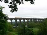
|
| Golden Grove Mansion | Llanfihangel Aberbythych | 7 August 1966 | SN5971019857 51°51′35″N 4°02′19″W / 51.859624093518°N 4.038623652229°W |
Country house | In park landscape to the south of, and overlooking, the Towy valley, 4 km south-west of Llandeilo. Two gate-lodges to the B4300 at north. A third, which is at the present principal park entrance, is in the village of Golden Grove. | 10926 | 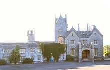
|
| Church of St Egwad, Llanfynydd | Llanfynydd | 7 August 1966 | SN5584027618 51°55′42″N 4°05′53″W / 51.928366601131°N 4.0980282999683°W |
In a round churchyard in the centre of the village. | 10927 |
| |
| Pont Cothi | Abergorlech, Llanfynydd | 7 August 1966 | SN5847233572 51°58′57″N 4°03′44″W / 51.982539784677°N 4.0622305353065°W |
Bridge | Spanning the Afon Cothi in the centre of Abergorlech, on the border between Llanfynydd and Llanfihangel Rhos y Corn communities. | 10928 | 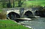
|
| Church of St Cathen, Llangathen | Llangathen | 7 August 1966 | SN5845022142 51°52′47″N 4°03′28″W / 51.87983606238°N 4.0578452936604°W |
Church | In a large churchyard occuping a high position at the S end of the village of Llangathen. | 10929 | 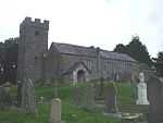
|
| Llethr Cadfan Farmhouse including former 'granary' building | Llangathen | 7 August 1966 | SN5781623135 51°53′19″N 4°04′03″W / 51.888596490385°N 4.06745906039°W |
Set back on the W side of a minor road 0.5km N of the crossroads with the A40 in Broad Oak. | 10932 |
| |
| Church of Saint Cadoc, Llangadog | Llangadog | 7 August 1966 | SN7062328456 51°56′22″N 3°53′01″W / 51.939537304581°N 3.8834773175928°W |
Church | Situated towards the upper end of Church Street, in large churchyard with stone boundary wall. | 10936 |
|
| Church House, Llangadog | Llangadog | 7 August 1966 | SN7064228414 51°56′21″N 3°52′59″W / 51.939164323294°N 3.8831852735735°W |
House | Situated on E side of street, just S of churchyard. | 10937 | .jpg)
|
| Red Lion Hotel, Llangadog | Llangadog | 7 August 1966 | SN7065028350 51°56′19″N 3°52′59″W / 51.938591088807°N 3.8830448762738°W |
Inn | Situated prominently in centre of Church Street. | 10940 | .jpg)
|
| Plas Glansevin | Llangadog | 7 August 1966 | SN7305028635 51°56′30″N 3°50′54″W / 51.941706020593°N 3.8482576090297°W |
Hall | Situated about 2 km E of Llangadog near the River Bran. | 10943 |
|
| Bont-ar-Towy | Llansadwrn | 7 August 1966 | SN6951028620 51°56′27″N 3°53′59″W / 51.94075052397°N 3.8997209718438°W |
Bridge | Bridge over River Towy on A4069 road to Llangadog, just E of A 40. | 10947 |
|
| Castle Green including front railings and gate | Llansawel | 7 August 1966 | SN6202836398 52°00′32″N 4°00′42″W / 52.008828308714°N 4.0116241563958°W |
10950 |
| ||
| The Dairy, Edwinsford | Llansawel | 7 August 1966 | SN6317434668 51°59′37″N 3°59′39″W / 51.99356820037°N 3.9942470346317°W |
10952 |
| ||
| Edwinsford Home Farm, Edwinsford | Llansawel | 7 August 1966 | SN6316934688 51°59′37″N 3°59′40″W / 51.993746670366°N 3.9943277986377°W |
10953 |
| ||
| Neuadd Fawr | Llanwrda | 7 August 1966 | SN7138031666 51°58′07″N 3°52′25″W / 51.9685580358°N 3.8736739923995°W |
Situated in village on E bank of the Afon Dulais, with short approach just NE of Pont y Neuadd. | 10956 |
| |
| Llandovery Castle | Llandovery | 3 August 1966 | SN7675734226 51°59′34″N 3°47′47″W / 51.992783695612°N 3.7963664297911°W |
Situated on prominent natural outcrop overlooking Afon Bran, on SE of main car park. | 10965 | 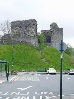
| |
| Ty-Ficar Pritchard | Llandovery | 3 August 1966 | SN7705134355 51°59′38″N 3°47′32″W / 51.994008225155°N 3.7921330872222°W |
Situated on street line some 100m W of Pont a'r Fran. | 10984 |
| |
| Church of St Dingat, Llandovery | Llandovery | 3 August 1966 | SN7637634086 51°59′29″N 3°48′07″W / 51.991440768211°N 3.8018619536735°W |
Church | Situated in large churchyard towards SW edge of town. | 10991 | 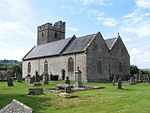
|
| Tabernacle Chapel, Llandovery | Llandovery | 26 February 1981 | SN7687734423 51°59′40″N 3°47′41″W / 51.994580662606°N 3.7946904476317°W |
Chapel | Situated set back from road in own courtyard, c30m from junction with Water Street. | 11018 |
|
| Llandeilo Bridge | Llandeilo | 14 March 1966 | SN6275922009 51°52′47″N 3°59′43″W / 51.879720644303°N 3.9952329824484°W |
Bridge | Spanning the River Towy and linking Llandeilo with Ffairfach; partly in Dyffryn Cennen community | 11040 | 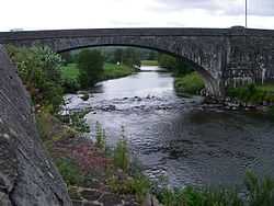
|
| Plas Dinefwr | Llandeilo | 7 August 1966 | SN6143222529 51°53′03″N 4°00′53″W / 51.884064083226°N 4.0147076418783°W |
Hall | 11098 |
| |
| Summer house at Plas Dinefwr | Llandeilo | 7 August 1966 | SN6140922502 51°53′02″N 4°00′54″W / 51.883815750775°N 4.0150307395384°W |
Summerhouse | 11099 |
| |
| Inner courtyard ranges at Dynevor Castle | Llandeilo | 7 August 1966 | SN6141822474 51°53′01″N 4°00′54″W / 51.883566404871°N 4.0148888097126°W |
Castle | 11102 | 
| |
| Outer courtyard ranges at Dynevor Castle | Llandeilo | 7 August 1966 | SN6142722434 51°53′00″N 4°00′53″W / 51.883209235296°N 4.0147420587119°W |
Castle | 11103 | 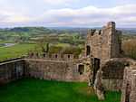
| |
| Farmhouse at Gelli Cefn y Rhos, Cwmdu | Gelli Cefn y Rhos, Talley | 28 April 1975 | SN6400531311 51°57′49″N 3°58′51″W / 51.963609034344°N 3.9808201463996°W |
Farmhouse | 11129 |
| |
| Parish church of St Michael, Talley | Talley | 7 August 1966 | SN6325432824 51°58′37″N 3°59′32″W / 51.97701914035°N 3.9923469285898°W |
Church | 11151 | 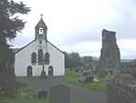
| |
| Aberglasney | Llangathen | 26 November 1951 | SN5813722136 51°52′47″N 4°03′45″W / 51.879702427436°N 4.0623869019525°W |
Country house | Approximately 300m W of Llangathen church, set in its own grounds on the W side of a minor road between Llangathen and the A40 at Broad Oak. | 11153 | 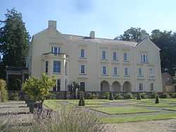
|
| Arcaded terrace walks enclosing walled garden at Aberglasney | Llangathen | 20 September 1990 | SN5809922108 51°52′46″N 4°03′47″W / 51.879441155716°N 4.0629270562391°W |
On the W side of the house. | 11154 | 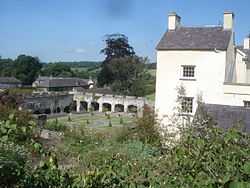
| |
| Gatehouse at Aberglasney | Llangathen | 20 September 1990 | SN5810122161 51°52′48″N 4°03′47″W / 51.879917872144°N 4.0629198276227°W |
Gatehouse | On the NW side of the house. | 11156 | 
|
| Old Bethel Chapel | Cwmamman | 9 March 1991 | SN6815114400 51°48′46″N 3°54′51″W / 51.812650966552°N 3.9140432524697°W |
Chapel | Located on a remote upland plateau on the N side of the Amman Valley approximately 1 km from the A474. Reached along short lane off mountain road at the lower end of a walled and gated burial ground. | 11168 |
|
| Court Henry | Llangathen | 7 August 1966 | SN5566422560 51°52′58″N 4°05′54″W / 51.882875892942°N 4.0984661344754°W |
House | In its own grounds on the W side of a minor road approximately 0.6km N of the A40 at its junction with the B4297. | 11176 |
|
| Erryd | Cilycwm | 29 March 1993 | SN7540438095 52°01′38″N 3°49′03″W / 52.027248542868°N 3.8174699248949°W |
House | Situated 2km S of Cilycwm on W side of Towy, approached by short drive E from road to Llandovery. | 11179 |
|
| Aberdeunant | Llansadwrn | 5 July 1993 | SN6714730764 51°57′34″N 3°56′06″W / 51.959455299117°N 3.9349051568129°W |
House | Situated some 400m up lane running N from Taliaris to Llansadwrn road, some 3km ENE of junction with B4302. | 11180 |
|
| The Raby Furnace | Llanelli Rural | 3 March 1966 | SN5039101507 51°41′32″N 4°09′57″W / 51.6923311091°N 4.1659355144°W |
Furnace | 100 m north of Stradey Park Hotel at the east side of a culverted stream in a deep valley beside the B4309. | 11870 |
|
| Church of St Non, Llannon | Llannon | 3 March 1966 | SN5397408475 51°45′21″N 4°07′01″W / 51.75588405055°N 4.1170593030287°W |
Church | In the centre of the village in a churchyard with stone wall and iron railings and gates to road at west; stone wall to minor road at north. | 11871 | 
|
| Church of St Illtyd, Cefn Sidan | Pembrey, Pembrey and Burry Port | 3 March 1966 | SN4285401217 51°41′16″N 4°16′29″W / 51.687661425534°N 4.2747591365846°W |
Church | In a large churchyard on the E side of the main square, and immediately S of the A484. | 11872 | 
|
| Pont Spwdwr (Spudder's Bridge) | Trimsaran | 3 March 1966 | SN4339205879 51°43′47″N 4°16′09″W / 51.729695844413°N 4.2690786258661°W |
Bridge | Approximately 2km NW of Trimsaran village centre, by-passed by and set back from the modern road. | 11875 | _-_geograph.org.uk_-_1154695.jpg)
|
| Kidwelly town gate | Kidwelly | 12 May 1963 | SN4072406941 51°44′19″N 4°18′29″W / 51.738483047107°N 4.3081638444587°W |
Town gate | Situated at SW end of Castle Street, some 130m WSW of Kidwelly Castle. | 11877 | 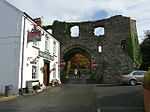
|
| Dovecote NW of Coleman Farm | Kidwelly | 12 May 1963 | SN3964107187 51°44′25″N 4°19′26″W / 51.74038339665°N 4.3239482605488°W |
Farmhouse | Situated in patch of scrub woodland at intersection of four fields on hillside some 300m NW of Coleman Farm, which is on the lower road from Kidwelly to Ferryside via St Ishmael. | 11879 |
|
| Stradey Castle | Llanelli Rural | 9 February 1986 | SN4910901537 51°41′32″N 4°11′04″W / 51.692256687964°N 4.1844819029615°W |
House | Entered by private drive from the B4308. House on terraced site with main basement area including external stairs to north-west. Landscaped parkland with woods to north. Terrace retaining-wall to south front with crenellated outer turrets. | 11884 |
|
| Parish church of St Ellyw, Llanelli | Llanelli | 30 November 1964 | SN5069900539 51°41′01″N 4°09′40″W / 51.68371607139°N 4.1610684110576°W |
Church | 11888 | 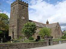
| |
| Tabernacle Chapel, including forecourt railings | Llanelli | 3 December 1992 | SN5051000394 51°40′57″N 4°09′49″W / 51.682362879793°N 4.1637380928545°W |
Chapel | 11900 | .jpg)
| |
| Carreg Cennen House | Dyffryn Cennen | 18 April 1991 | SN6531319282 51°51′21″N 3°57′26″W / 51.855840972599°N 3.9570880440175°W |
Situated about 0.5 km N of Trap, approached by avenue of limes from gates set in stone flanking walls on E side of road to Llandeilo. | 15616 |
| |
| Church of St Michael, Llanfihangel ar Arth | Llanfihangel ar Arth | 23 June 1967 | SN4560839922 52°02′10″N 4°15′08″W / 52.036152421799°N 4.2522597286937°W |
At the N end of Llanfihangel ar Arth village, set in a walled churchyard overlooking the Teifi valley. | 15631 |
| |
| Edwinsford, Llansawel | Talley | 26 November 1951 | SN6312034581 51°59′34″N 3°59′42″W / 51.992773148818°N 3.9949982539417°W |
15766 |
| ||
| Pont Newydd | Cilycwm | 29 November 1995 | SN7581538432 52°01′49″N 3°48′42″W / 52.030369230314°N 3.8116050488987°W |
Bridge | Situated some 1.5 km S of Cilycwm on road to Llandovery. | 16986 | 
|
| The Coach house at Henllys | Cilycwm | 29 November 1995 | SN7549236667 52°00′52″N 3°48′56″W / 52.014436157771°N 3.8156681093409°W |
17000 |
| ||
| Tinhouse, Old Castle Tinplate Works | Llanelli | 31 July 1997 | SS5049499006 51°40′12″N 4°09′48″W / 51.669887774052°N 4.1633747377951°W |
On the western side of Llanelli, S of the A484. | 18657 |
| |
| Church of St Margaret of Antioch, Pendine | Pendine | 31 October 1997 | SN2287308787 51°44′59″N 4°34′03″W / 51.749692075899°N 4.5673704679674°W |
Church | About 1km above Dolwen Point, in churchyard near junction of B4314 and minor road to Marros. | 19014 | 
|
| Capel Brynseion | Cwmamman | 1 September 1998 | SN6754913574 51°48′18″N 3°55′21″W / 51.80508597723°N 3.922454769654°W |
Chapel | Situated in the centre of Glanamman some 25m S of A474 on the E side of High Street. | 19220 | .jpg)
|
| Cold-roll Engine-house at former Kidwelly Tinplate Works | Kidwelly | 28 July 1998 | SN4219107937 51°44′52″N 4°17′15″W / 51.747847072394°N 4.2873880628424°W |
Situated at NE end of Kidwelly Industrial Museum site, which is some 2km NE of Kidwelly, in Gwendraeth Fach valley. | 20197 |
| |
| Felinfoel Brewery | Llanelli Rural | 16 October 1998 | SN5176002052 51°41′51″N 4°08′47″W / 51.697591896982°N 4.1463757323335°W |
Brewery | Prominently sited at E side of the A 476 in Felinfoel, Llanelli. Brewery yard to south and to rear. Office building to south. | 20532 | 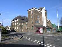
|
| Hoffmann Kiln of Eclipse Brickworks | Llanelli Rural | 16 October 1998 | SN5010305290 51°43′34″N 4°10′18″W / 51.726243056079°N 4.1717270288568°W |
W side of the former Llanelli and Mynydd Mawr Railway, 1/2 km SE of Horeb. Site of siding with a passing loop and remains of brickwork loading platform at E. Site of moulding & drying shed and ruin of engine house (for tramway to claypit) at E. | 20537 |
| |
| Church of St Michael and all Angels, Llanelli | Llanelli Rural | 16 October 1998 | SN5274301009 51°41′19″N 4°07′54″W / 51.688480020243°N 4.1317222455764°W |
At the south side of Bryngwyn Road, Dafen. Stone wall to street and to west side; timber war-memorial lychgate. | 20545 |
| |
| Llandeilo Bridge | Dyffryn Cennen | 14 March 1966 | SN6275421989 51°52′46″N 3°59′43″W / 51.879539702895°N 3.9952976149137°W |
Bridge | Spanning the River Towy and linking Llandeilo with Ffairfach; partly in Llandeilo community. | 20900C |
|
| Cross Hands Public Hall | Llannon | 1 December 1999 | SN5595713059 51°47′51″N 4°05′25″W / 51.797586138256°N 4.0902531162903°W |
500m north-west of Crosshands crossroads | 21086 |
| |
| Cefnarthen Chapel | Llanfair ar y Bryn | 25 February 1999 | SN8393535059 52°00′07″N 3°41′32″W / 52.001819343299°N 3.6921568544041°W |
Situated at the end of a lane off a minor road leading from Pentrebach to Babel approximately 1km to the NW. | 21395 |
| |
| Coedweddus | Llangadog | 19 July 1999 | SN7436527762 51°56′03″N 3°49′44″W / 51.934160196002°N 3.8288186832097°W |
Situated some 4 km E of Llangadog, reached by drive running N from lane to Llanddeusant. | 21992 |
| |
| Bont-ar-Towy | Llangadog | 19 July 1999 | SN6952828619 51°56′27″N 3°53′58″W / 51.940745768344°N 3.8994588920832°W |
Situated on A4069 about 1 km W of Llangadog, just E of junction with A40. Half of bridge is in Llansadwrn community. | 21995 |
| |
| Capel Libanus | Llansadwrn | 29 July 1999 | SN6819931923 51°58′12″N 3°55′12″W / 51.970120602937°N 3.920049251814°W |
Chapel | Situated on N side of lane some 1.3 km W of Llansadwrn. | 22122 |
|
| Church of St Michael, Llanfihangel Aberbythych | Llanfihangel Aberbythych | 27 August 1999 | SN5897119712 51°51′29″N 4°02′57″W / 51.858134546119°N 4.0492883828381°W |
Church | In the village of Golden Grove to the west of the street, nearly opposite to Golden Grove park entrance. Stone-walled churchyard with stile; lychgate separately listed. | 22179 |
|
| Golden Grove Stable Block | Llanfihangel Aberbythych | 27 August 1999 | SN5962419809 51°51′33″N 4°02′23″W / 51.859171127785°N 4.0398521271702°W |
Stables | To the west of the service wing at Golden Grove, to which it is linked by yards and a covered way. Rubblestone enclosing wall at north, continuing the line of the terrace wall of the house. | 22204 |
|
| Capel Panteg and attached vestry to left | Abergwili | 9 February 1999 | SN4832225168 51°54′16″N 4°12′22″W / 51.904353020654°N 4.2062024285408°W |
Situated in a remote valley N of a minor road some 4km NE of Whitemill. | 22268 |
| |
| Capel Salem including forecourt railings | Llangyndeyrn | 9 February 1999 | SN4553913884 51°48′08″N 4°14′30″W / 51.802211142056°N 4.241577336065°W |
Chapel | Situated in the centre of Llangyndeyrn approximately 250m SW of the B4306. | 22269 |
|
| Williams Pantycelyn Memorial Chapel | Llandovery | 2 January 2000 | SN7690234387 51°59′39″N 3°47′40″W / 51.994262710418°N 3.7943135803644°W |
Chapel | Situated near the centre of Llandovery on the N side of the High Street between Orchard Street and Water Street. | 22801 |
|
| Cyffig Church | Eglwyscummin | 10 November 2000 | SN2081013933 51°47′43″N 4°36′00″W / 51.795254171915°N 4.599879762134°W |
Church | Situated on the S side of a minor road some 3km SE of Whitland. | 24116 |
|
| Church of the Holy Trinity, Llanegwad | Pont-ar-Gothi, Llanegwad | 5 February 2001 | SN5098022611 51°52′56″N 4°09′59″W / 51.882098968773°N 4.1664901946619°W |
Church | About 1km NE of Pont-ar-Gothi, in churchyard on the E side of a minor road and N bank of Afon Cothi. | 25162 | .jpg)
|
| Pilgrims graves by ruins of St Michael's Church | St Clears | 6 November 2001 | SN3027613338 51°47′34″N 4°27′45″W / 51.792870786676°N 4.4624606241329°W |
Graves | In enclosed cemetery, immediately S of the church ruins. | 25491 | |
| Pilgrim's Graves S of ruins of St Michaels Church | St Clears | 6 November 2001 | SN3028713313 51°47′34″N 4°27′44″W / 51.792649566807°N 4.4622890414696°W |
Graves | Near S perimeter of the cemetery. | 25492 |
|
| W. R. H. Powell memorial in churchyard and iron railings | Llanboidy | 8 June 2001 | SN2166223238 51°52′45″N 4°35′32″W / 51.879102159521°N 4.5923369722422°W |
Memorial | Situated in the churchyard in Llanboidy village, to the E of the parish church. | 25616 |
|
| Allt-y-Cafan Bridge | Llangeler | 6 April 1996 | SN3867539205 52°01′40″N 4°21′10″W / 52.027732887082°N 4.3529056663016°W |
Bridge | Spanning the river Teifi on the County boundary with Ceredigion on the road N of Pentrecwrt. Also in Ceredigion. | 25706 | 
|
| Church of St Cynog, Llangynog | Llangynog | 17 October 2001 | SN3385114929 51°48′30″N 4°24′41″W / 51.808239054962°N 4.4114348759713°W |
Church | Situated about 1 km S of Llangynog. | 25800 | 
|
| Coach House and Stable Range at Y Plas | Llansteffan | 11 May 2002 | SN3487910432 51°46′05″N 4°23′40″W / 51.768147344089°N 4.3943963024756°W |
Coach House/Stables | Located SW of Plas mansion, at the end of a private access road leading S from Llansteffan village. | 27075 |
|
| White Bridge (The bascule railway bridge) | Carmarthen | 12 May 2002 | SN4051419246 51°50′56″N 4°19′01″W / 51.848966923546°N 4.3168638662337°W |
Bascule bridge | Railway bridge over Towy river and accessed via footpath in field behind Queen Elizabeth Maridunum School. Also in Llangunnor. | 80709 | .jpg)
|
| Former Kidwelly & Llanelly Canal aqueduct | Trimsaran | 23 July 2003 | SN4275705300 51°43′28″N 4°16′41″W / 51.724315925315°N 4.2780039289213°W |
Aqueduct | Spanning the Afon Gwendraeth Fawr NW of Morfa Mawr Farm, approximately 600m NW of Llandyry church. | 81323 |
|
| Dome gunnery trainer at Pembrey Airfield | Pembrey and Burryport | 25 November 2003 | SN4075703714 51°42′34″N 4°18′22″W / 51.709501735234°N 4.3062098837196°W |
Dome trainer building | In a field on the E side of the former airfield, approximately 550m NW of Brooklands Farmhouse. | 82066 | 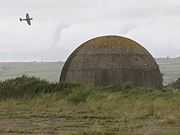
|
| White Bridge (the bascule railway bridge) | Llangunnor | 12 May 2002 | SN4053219239 51°50′56″N 4°19′00″W / 51.848909194342°N 4.3165995382626°W |
Bascule bridge | Spanning the Afon Tywi to the SW of Carmarthen. Also in Carmarthen. | 82396 | |
Notes
- ↑ Sometimes known as OSGB36, the grid reference is based on the British national grid reference system used by the Ordnance Survey.
- ↑ The "HB Number" is a unique number assigned to each listed building by Cadw.
See also
References
- ↑ "Buildings & Conservation Areas". Cadw. Retrieved 18 June 2013.
- ↑ "Planning (Listed Buildings and Conservation Areas) Act 1990". The National Archives. Retrieved 18 June 2013.
External links
![]() Media related to Grade II* listed buildings in Carmarthenshire at Wikimedia Commons
Media related to Grade II* listed buildings in Carmarthenshire at Wikimedia Commons
| ||||||||||||||||||||||||||