| Name |
Location |
Type |
Completed | Date designated |
Grid ref.
Geo-coordinates |
Entry number | Image |
|
|
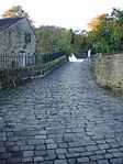
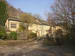
| The Old Bridge over the Hebden Water |
Hebden Bridge, Hebden Royd |
Packhorse bridge |
1510 !c.1510 |
01963-07-19-000019 July 1963 |
SD9921727294
53°44′31″N 2°00′48″W / 53.742026°N 2.01335°W / 53.742026; -2.01335 (The Old Bridge over the Hebden Water) |
1228914 |
More images
|
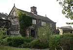
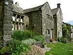
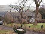
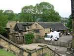
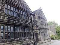
| Barn 15 metres to north of Lower Hathershelf |
Luddendenfoot, Hebden Royd |
Barn |
1600 !Late 16th century or early 17th century |
01963-07-19-000019 July 1963 |
SE0262225258
53°43′25″N 1°57′42″W / 53.723721°N 1.961742°W / 53.723721; -1.961742 (Barn 15 metres to north of Lower Hathershelf) |
1229380 |

|
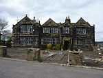
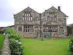
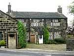
| Brearley Hall |
Luddendenfoot, Hebden Royd |
House |
1590 !Late 16th century |
01963-07-19-000019 July 1963 |
SE0303725929
53°43′47″N 1°57′20″W / 53.729749°N 1.955446°W / 53.729749; -1.955446 (Brearley Hall) |
1229035 |
|
| Luddenden Foot United Reformed Church, the Manse and Chapel House |
Luddendenfoot, Calderdale |
Manse |
1859 |
01980-07-11-000011 July 1980 |
SE0398424477
53°43′00″N 1°56′28″W / 53.716693°N 1.94111°W / 53.716693; -1.94111 (Luddenden Foot United Reformed Church, the Manse and Chapel House) |
1134555 |
|
| Birchen Lee Carr and attached barn |
Mytholmroyd, Hebden Royd |
House |
1651 !Mid-17th century |
01963-07-19-000019 July 1963 |
SE0142226694
53°44′12″N 1°58′48″W / 53.736632°N 1.979922°W / 53.736632; -1.979922 (Birchen Lee Carr and attached barn) |
1230186 |
|
| Broad Bottom Old Hall |
Mytholmroyd, Hebden Royd |
House |
1551 !Mid-16th century |
01963-07-19-000019 July 1963 |
SE0078926591
53°44′09″N 1°59′22″W / 53.735707°N 1.989518°W / 53.735707; -1.989518 (Broad Bottom Old Hall) |
1279330 |
|
| Great Burlees |
Mytholmroyd, Hebden Royd |
House |
1590 !Late 16th century |
01963-07-19-000019 July 1963 |
SE0000327029
53°44′23″N 2°00′05″W / 53.739645°N 2.001433°W / 53.739645; -2.001433 (Great Burlees) |
1279349 |
|
| Little Burlees Farmhouse and attached barn |
Mytholmroyd, Hebden Royd |
House |
1637 |
01963-07-19-000019 July 1963 |
SE0013727108
53°44′25″N 1°59′58″W / 53.740355°N 1.999402°W / 53.740355; -1.999402 (Little Burlees Farmhouse and attached barn) |
1279350 |
|
| Mytholmroyd Farmhouse |
Mytholmroyd, Hebden Royd |
House |
1625 !Early–mid-17th century |
01963-07-19-000019 July 1963 |
SE0123525755
53°43′41″N 1°58′58″W / 53.728193°N 1.98276°W / 53.728193; -1.98276 (Mytholmroyd Farmhouse) |
1230315 |
|
| Redacre House |
Mytholmroyd, Hebden Royd |
House |
1590 !Late 16th century |
01963-07-19-000019 July 1963 |
SE0118826273
53°43′58″N 1°59′00″W / 53.732848°N 1.98347°W / 53.732848; -1.98347 (Redacre House) |
1229121 |
|
| Stoney Royd Farmhouse |
Mytholmroyd, Hebden Royd |
House |
1715 |
01984-06-21-000021 June 1984 |
SE0212926632
53°44′10″N 1°58′09″W / 53.736072°N 1.969204°W / 53.736072; -1.969204 (Stoney Royd Farmhouse) |
1299703 |
|
| Wadsworth Banks Farmhouse |
Raw Lane, Mytholmroyd, Hebden Royd |
House |
1650 !17th century |
01963-07-19-000019 July 1963 |
SE0150826763
53°44′14″N 1°58′43″W / 53.737252°N 1.978618°W / 53.737252; -1.978618 (Wadsworth Banks Farmhouse) |
1278733 |
|
| Windle Hill |
Mytholmroyd, Hebden Royd |
House |
1590 !Late 16th century |
01984-06-21-000021 June 1984 |
SE0132624646
53°43′06″N 1°58′53″W / 53.718225°N 1.981385°W / 53.718225; -1.981385 (Windle Hill) |
1230058 |
|
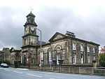
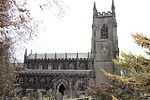
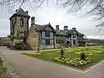
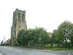
| Church of St Thomas |
Heptonstall |
Church |
1854 !1850–54 |
01966-11-01-00001 November 1966 |
SD9864528006
53°44′54″N 2°01′19″W / 53.748424°N 2.022026°W / 53.748424; -2.022026 (Church of St Thomas) |
1226171 |
More images
|
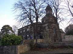
| Church of St Thomas a' Becket |
Heptonstall |
Church |
1260 |
01966-11-01-00001 November 1966 |
SD9867528058
53°44′56″N 2°01′18″W / 53.748891°N 2.021572°W / 53.748891; -2.021572 (Church of St Thomas a' Becket) |
1226170 |
More images
|
| Greenwood Lee |
Heptonstall |
Clothiers house |
1712 |
01961-11-01-00001 November 1961 |
SD9703329562
53°45′45″N 2°02′47″W / 53.762402°N 2.046486°W / 53.762402; -2.046486 (Greenwood Lee) |
1226793 |
|
| Barn 10 metres to north-west of Greenwood Lee |
Heptonstall |
Aisled barn |
1590 !Late 16th century |
01966-11-01-00001 November 1966 |
SD9699829578
53°45′45″N 2°02′49″W / 53.762546°N 2.047017°W / 53.762546; -2.047017 (Barn 10 metres to north-west of Greenwood Lee) |
1265719 |
|
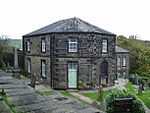
| Wesleyan Methodist Chapel |
Heptonstall |
Wesleyan methodist chapel |
1764 !c.1764 |
01966-11-01-00001 November 1966 |
SD9877128160
53°44′59″N 2°01′12″W / 53.749808°N 2.020116°W / 53.749808; -2.020116 (Wesleyan Methodist Chapel) |
1226441 |
More images
|
| Field Head |
Colden, Heptonstall |
House |
1690 !Late 17th century |
01984-12-12-000012 December 1984 |
SD9538528585
53°45′13″N 2°04′17″W / 53.753608°N 2.071469°W / 53.753608; -2.071469 (Field Head) |
1225892 |
|
| Colden Great House |
Colden, Heptonstall |
Clothiers house |
1575 !Second half of 16th century |
01966-11-01-00001 November 1966 |
SD9595928776
53°45′19″N 2°03′46″W / 53.75533°N 2.062767°W / 53.75533; -2.062767 (Colden Great House) |
1226080 |
|
| Old Edge |
Colden, Heptonstall |
House |
1610 !Early 17th century |
01966-11-01-00001 November 1966 |
SD9563929243
53°45′34″N 2°04′03″W / 53.759525°N 2.067627°W / 53.759525; -2.067627 (Old Edge) |
1226099 |
|
| Great Greave |
Soyland, Ripponden |
Aisled house |
1590 !Late 16th century |
01966-08-15-000015 August 1966 |
SE0177720653
53°40′56″N 1°58′28″W / 53.682334°N 1.974572°W / 53.682334; -1.974572 (Great Greave) |
1277380 |
|
| Great House |
Great House Lane, Soyland, Ripponden |
House |
1624 |
01966-08-15-000015 August 1966 |
SE0244219262
53°40′11″N 1°57′52″W / 53.669829°N 1.964515°W / 53.669829; -1.964515 (Great House) |
1278210 |
|
| Lower Moor Farmhouse and attached barn |
Ripponden |
Clothiers house |
1632 !2nd quarter of 17th century |
01984-07-16-000016 July 1984 |
SE0321420050
53°40′37″N 1°57′10″W / 53.676907°N 1.952822°W / 53.676907; -1.952822 (Lower Moor Farmhouse and attached barn) |
1277496 |
|
| Ripponden Old Bridge |
Ripponden |
Bridge |
1533 |
01966-08-15-000015 August 1966 |
SE0406219781
53°40′28″N 1°56′24″W / 53.674484°N 1.939988°W / 53.674484; -1.939988 (Ripponden Old Bridge) |
1232463 |
More images
|
| Swift Cottage and gate piers in inner courtyard, Swift Mews & Swift Place |
Rochdale Rd, Ripponden |
House |
1626 |
01966-08-15-000015 August 1966 |
SE0264418888
53°39′59″N 1°57′41″W / 53.666466°N 1.96146°W / 53.666466; -1.96146 (Swift Cottage and gate piers in inner courtyard, Swift Mews & Swift Place) |
1277094 |
|
| Upper Cockcroft |
Rishworth, Ripponden |
House |
1642 |
01966-08-15-000015 August 1966 |
SE0239618091
53°39′33″N 1°57′55″W / 53.659304°N 1.965219°W / 53.659304; -1.965219 (Upper Cockcroft) |
1277194 |
|
| Upper Cockcroft Farmhouse |
Rishworth, Ripponden |
House |
1607 |
01966-08-15-000015 August 1966 |
SE0241718101
53°39′34″N 1°57′54″W / 53.659394°N 1.964902°W / 53.659394; -1.964902 (Upper Cockcroft Farmhouse) |
1231972 |
|
| Wormald Farmhouse |
Barkisland, Ripponden |
House |
1651 !Mid-17th century |
01978-10-12-000012 October 1978 |
SE0602018985
53°40′02″N 1°54′37″W / 53.667311°N 1.910365°W / 53.667311; -1.910365 (Wormald Farmhouse) |
1231233 |
|
| Bean Hole Head Farmhouse and attached Barn |
Todmorden |
House |
1638 |
01966-11-22-000022 November 1966 |
SD9501624961
53°43′16″N 2°04′37″W / 53.721032°N 2.077006°W / 53.721032; -2.077006 (Bean Hole Head Farmhouse and attached Barn) |
1133763 |
|
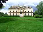
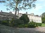
| Dobroyd Castle |
Todmorden |
Country house |
1869 !1866–69 |
01966-11-22-000022 November 1966 |
SD9296223809
53°42′38″N 2°06′29″W / 53.710654°N 2.108106°W / 53.710654; -2.108106 (Dobroyd Castle) |
1134570 |
More images
|
| Higher Ashes Farmhouse |
Todmorden |
Clothiers house |
1691 |
01966-11-22-000022 November 1966 |
SD9481425402
53°43′30″N 2°04′48″W / 53.724994°N 2.080074°W / 53.724994; -2.080074 (Higher Ashes Farmhouse) |
1133774 |
|
| Lower Ashes Farmhouse and attached gate piers |
Todmorden |
House |
1610 |
01966-11-26-000026 November 1966 |
SD9494225318
53°43′27″N 2°04′41″W / 53.72424°N 2.078133°W / 53.72424; -2.078133 (Lower Ashes Farmhouse and attached gate piers) |
1133773 |
|
| Lower East Lee and attached barn |
Todmorden |
Farmhouse |
1610 |
01966-11-22-000022 November 1966 |
SD9601225461
53°43′32″N 2°03′43″W / 53.725535°N 2.061919°W / 53.725535; -2.061919 (Lower East Lee and attached barn) |
1134577 |
|
| Stansfield Hall |
Todmorden |
House |
1640 |
01974-04-19-000019 April 1974 |
SD9407524675
53°43′06″N 2°05′29″W / 53.718452°N 2.09126°W / 53.718452; -2.09126 (Stansfield Hall) |
1230848 |
|
| Steanor Bottom Toll House |
Todmorden |
Toll house |
1824 |
01966-11-22-000022 November 1966 |
SD9451619835
53°40′30″N 2°05′04″W / 53.674954°N 2.08449°W / 53.674954; -2.08449 (Steanor Bottom Toll House) |
1230648 |
|
| Swallowshaw and attached barn |
Todmorden |
Clothiers house |
1663 |
01966-11-22-000022 November 1966 |
SD9503425660
53°43′38″N 2°04′36″W / 53.727315°N 2.076745°W / 53.727315; -2.076745 (Swallowshaw and attached barn) |
1134568 |
|
| Todmorden Hall |
Todmorden |
House |
1610 !Early 17th century |
01972-05-05-00005 May 1972 |
SD9354424085
53°42′47″N 2°05′57″W / 53.713142°N 2.099294°W / 53.713142; -2.099294 (Todmorden Hall) |
1228983 |
|
| Upper Shaw |
Langfield, Todmorden |
Farmhouse |
1651 !Mid-17th century |
01966-11-22-000022 November 1966 |
SD9599324256
53°42′53″N 2°03′44″W / 53.714704°N 2.062191°W / 53.714704; -2.062191 (Upper Shaw) |
1278750 |
|
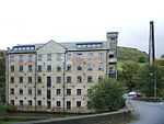
| Woodhouse Mill, engine house and detached chimney 20 metres to south |
Todmorden |
Steam mill |
1832 |
01984-02-22-000022 February 1984 |
SD9515324438
53°42′59″N 2°04′30″W / 53.716333°N 2.074921°W / 53.716333; -2.074921 (Woodhouse Mill, engine house and detached chimney 20 metres to south) |
1278321 |
|
| Akroyd Farm Cottage/Akroyd Farmhouse |
Pecket Well, Wadsworth |
Clothiers house |
1690 !Late 17th century |
01966-11-01-00001 November 1966 |
SD9958429157
53°45′32″N 2°00′28″W / 53.758771°N 2.007789°W / 53.758771; -2.007789 (Akroyd Farm Cottage/Akroyd Farmhouse) |
1226935 |
|
| Wainsgate Baptist Church and attached Sunday School |
Wadsworth |
Sunday school |
1859 |
01982-04-29-000029 April 1982 |
SD9982828798
53°45′20″N 2°00′15″W / 53.755544°N 2.004088°W / 53.755544; -2.004088 (Wainsgate Baptist Church and attached Sunday School) |
1227399 |
|
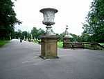
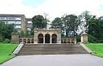
| 6 cast-iron urns on pedestals to terrace in People's Park |
Halifax |
Urn |
1856 !c.1856 |
01973-11-23-000023 November 1973 |
SE0843824942
53°43′15″N 1°52′25″W / 53.72082°N 1.873609°W / 53.72082; -1.873609 (6 cast-iron urns on pedestals to terrace in People's Park) |
1242836 |
|
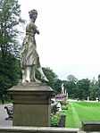
| 8 statues to terrace in People's Park |
Halifax |
Statue |
1856 !c.1856 |
01973-11-23-000023 November 1973 |
SE0843924925
53°43′14″N 1°52′25″W / 53.720667°N 1.873594°W / 53.720667; -1.873594 (8 statues to terrace in People's Park) |
1261517 |
|
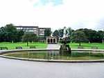
| Fountain and basin in People's Park |
Halifax |
Fountain |
1856 !c.1856 |
01973-11-23-000023 November 1973 |
SE0851624875
53°43′13″N 1°52′21″W / 53.720217°N 1.872429°W / 53.720217; -1.872429 (Fountain and basin in People's Park) |
1254010 |
|
| Steps to centre of terrace in People's Park |
Halifax |
Steps |
1856 !c.1856 |
01973-11-23-000023 November 1973 |
SE0846324870
53°43′13″N 1°52′24″W / 53.720173°N 1.873232°W / 53.720173; -1.873232 (Steps to centre of terrace in People's Park) |
1261518 |
|
| Northern bridge in People's Park |
Halifax |
Footbridge |
1856 !c.1856 |
01973-11-23-000023 November 1973 |
SE0856724930
53°43′15″N 1°52′18″W / 53.72071°N 1.871654°W / 53.72071; -1.871654 (Northern bridge in People's Park) |
1254014 |
|
| Southern bridge in People's Park |
Halifax |
Bridge |
1856 !c.1856 |
01973-11-23-000023 November 1973 |
SE0858824868
53°43′13″N 1°52′17″W / 53.720153°N 1.871338°W / 53.720153; -1.871338 (Southern bridge in People's Park) |
1254015 |
|
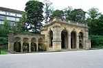
| Pavilion with screen walls and fountain pools in People's Park |
Halifax |
Pavilion |
1856 !c.1856 |
01973-11-23-000023 November 1973 |
SE0842824868
53°43′13″N 1°52′26″W / 53.720155°N 1.873762°W / 53.720155; -1.873762 (Pavilion with screen walls and fountain pools in People's Park) |
1242770 |
|
| Platform at north end of terrace with urn in People's Park |
Halifax |
Balustrade |
1856 !c.1856 |
01973-11-23-000023 November 1973 |
SE0843024965
53°43′16″N 1°52′25″W / 53.721027°N 1.873729°W / 53.721027; -1.873729 (Platform at north end of terrace with urn in People's Park) |
1254008 |
|
| Platform at south end of terrace with urn in People's Park |
Halifax |
Balustrade |
1856 !c.1856 |
01973-11-23-000023 November 1973 |
SE0844624772
53°43′09″N 1°52′25″W / 53.719292°N 1.873492°W / 53.719292; -1.873492 (Platform at south end of terrace with urn in People's Park) |
1242811 |
|
| Allangate |
Halifax |
Country house |
1810 !c.1810 |
01992-12-14-000014 December 1992 |
SE0739324303
53°42′54″N 1°53′22″W / 53.715092°N 1.88946°W / 53.715092; -1.88946 (Allangate) |
1330019 |
|
| Somerset House |
Halifax |
Detached house |
1766 |
01954-11-03-00003 November 1954 |
SE0916325082
53°43′19″N 1°51′45″W / 53.722066°N 1.862618°W / 53.722066; -1.862618 (Somerset House) |
1133901 |
|
| Staups House |
George St, Halifax |
House |
1664 |
01954-11-03-00003 November 1954 |
SE1063026389
53°44′02″N 1°50′25″W / 53.733786°N 1.840342°W / 53.733786; -1.840342 (Staups House) |
1261494 |
|
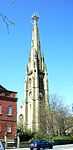
| Steeple of Square Congregational Church |
Halifax |
Church |
1855 |
01950-03-02-00002 March 1950 |
SE0961325064
53°43′19″N 1°51′21″W / 53.721897°N 1.855799°W / 53.721897; -1.855799 (Steeple of Square Congregational Church) |
1258888 |
More images
|
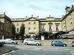
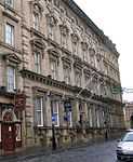
| White Swan Hotel |
Halifax |
Hotel |
1858 |
01963-07-31-000031 July 1963 |
SE0929325268
53°43′25″N 1°51′38″W / 53.723736°N 1.860643°W / 53.723736; -1.860643 (White Swan Hotel) |
1258062 |
|
| 1 Woolshops |
Halifax |
Jettied house |
1600 !Late 16th century to early 17th century |
01954-11-03-00003 November 1954 |
SE0939425235
53°43′24″N 1°51′33″W / 53.723437°N 1.859113°W / 53.723437; -1.859113 (1 Woolshops) |
1272942 |
|
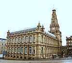
| Town Hall |
Halifax |
Town hall |
1863 |
01963-07-31-000031 July 1963 |
SE0928725345
53°43′28″N 1°51′39″W / 53.724428°N 1.860731°W / 53.724428; -1.860731 (Town Hall) |
1314024 |
More images
|
| Wainhouse Tower |
Halifax |
Belvedere |
1875 !1871–75 |
01954-11-03-00003 November 1954 |
SE0781023999
53°42′44″N 1°52′59″W / 53.712354°N 1.883149°W / 53.712354; -1.883149 (Wainhouse Tower) |
1133900 |
More images
|
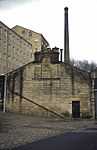
| Shaw Lodge Mill chimney |
Halifax |
Textile mill |
1855 |
02007-04-03-00003 April 2007 |
SE0971224235
53°42′52″N 1°51′16″W / 53.714444°N 1.854325°W / 53.714444; -1.854325 (Shaw Lodge Mill chimney) |
1391916 |
More images
|
| Shaw Lodge Mill engine house and boiler house |
Halifax |
Boiler house |
1855 |
02007-04-03-00003 April 2007 |
49°46′01″N 7°33′26″W / 49.766806°N 7.55716°W / 49.766806; -7.55716 (Shaw Lodge Mill engine house and boiler house) |
1391915 |
|
| Shaw Lodge Mill former combing shed |
Halifax |
Fireproof building |
1876 |
02007-04-03-00003 April 2007 |
SE0966624278
53°42′53″N 1°51′18″W / 53.714831°N 1.85502°W / 53.714831; -1.85502 (Shaw Lodge Mill former combing shed) |
1391913 |
|
| Shaw Lodge Mill office building |
Halifax |
Textile mill |
1865 |
02007-04-03-00003 April 2007 |
SE0962424250
53°42′52″N 1°51′20″W / 53.71458°N 1.855657°W / 53.71458; -1.855657 (Shaw Lodge Mill office building) |
1391914 |
|
| Shaw Lodge Mill warehouse and mills |
Halifax |
Spinning mill |
1830 |
02007-04-03-00003 April 2007 |
SE0970324197
53°42′51″N 1°51′16″W / 53.714102°N 1.854462°W / 53.714102; -1.854462 (Shaw Lodge Mill warehouse and mills) |
1391936 |
|
| Shaw Lodge Mill weaving sheds and clock tower |
Halifax |
Worsted mill |
1876 |
02007-04-03-00003 April 2007 |
SE0965824060
53°42′46″N 1°51′19″W / 53.712872°N 1.855148°W / 53.712872; -1.855148 (Shaw Lodge Mill weaving sheds and clock tower) |
1391911 |
|
| Coley Hall |
Hipperholme |
House |
1690 !Late 17th century |
01967-01-03-00003 January 1967 |
SE1291226942
53°44′19″N 1°48′21″W / 53.738706°N 1.805728°W / 53.738706; -1.805728 (Coley Hall) |
1183818 |
|
| Archway to Coley Hall |
Hipperholme |
Gate |
1649 |
01967-01-03-00003 January 1967 |
SE1290726905
53°44′18″N 1°48′21″W / 53.738373°N 1.805805°W / 53.738373; -1.805805 (Archway to Coley Hall) |
1133869 |
|
| Bank House |
Salterhebble |
House |
1599 !17th century and earlier |
01954-11-03-00003 November 1954 |
SE0955022595
53°41′59″N 1°51′25″W / 53.699706°N 1.856829°W / 53.699706; -1.856829 (Bank House) |
1313994 |
|
| Shibden Hall Museum |
Shibden Park, Shibden |
House |
1575 !Later 16th century |
01954-11-03-00003 November 1954 |
SE1066925750
53°43′41″N 1°50′23″W / 53.728042°N 1.839773°W / 53.728042; -1.839773 (Shibden Hall Museum) |
1254036 |
More images
|
| Barn to Shibden Hall Museum |
Shibden Park, Shibden |
Museum |
1610 !Early 17th century |
01954-11-03-00003 November 1954 |
SE1065625774
53°43′42″N 1°50′24″W / 53.728258°N 1.839969°W / 53.728258; -1.839969 (Barn to Shibden Hall Museum) |
1254037 |
|
| Belle Vue (public Library) |
Halifax |
House |
1810 !Early 19th century |
01954-11-03-00003 November 1954 |
SE0845925068
53°43′19″N 1°52′24″W / 53.721952°N 1.873287°W / 53.721952; -1.873287 (Belle Vue (public Library)) |
1133879 |
|
| Borough Market with Shopping Arcade to North |
Halifax |
Market hall |
1895 !1891–95 |
01973-11-23-000023 November 1973 |
SE0937425122
53°43′21″N 1°51′34″W / 53.722422°N 1.859419°W / 53.722422; -1.859419 (Borough Market with Shopping Arcade to North) |
1281516 |
More images
|
| 2–5 Backhold Lane |
Halifax |
House |
1650 !17th century |
01954-11-03-00003 November 1954 |
SE1011423043
53°42′13″N 1°50′54″W / 53.703722°N 1.848272°W / 53.703722; -1.848272 (2–5 Backhold Lane) |
1314032 |
|
| Congregational Sunday School |
Halifax |
Sunday school |
1772 |
01954-11-03-00003 November 1954 |
SE0962425035
53°43′18″N 1°51′20″W / 53.721636°N 1.855633°W / 53.721636; -1.855633 (Congregational Sunday School) |
1254043 |
|
| Church of St Paul |
King Cross, Halifax |
Church |
1912 !1911–12 |
01973-11-23-000023 November 1973 |
SE0802024478
53°43′00″N 1°52′48″W / 53.716656°N 1.879955°W / 53.716656; -1.879955 (Church of St Paul) |
1258113 |
More images
|
| Church of St Matthew |
Rastrick |
Church |
1796 !c.1796 |
01967-01-03-00003 January 1967 |
SE1385421578
53°41′26″N 1°47′30″W / 53.69047°N 1.791685°W / 53.69047; -1.791685 (Church of St Matthew) |
1183810 |
More images
|
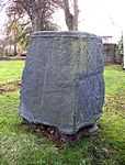
| Cross base in churchyard of St Matthew's Church |
Rastrick |
Cross |
0950 !10th century |
01967-01-03-00003 January 1967 |
SE1383121596
53°41′26″N 1°47′31″W / 53.690632°N 1.792032°W / 53.690632; -1.792032 (Cross base in churchyard of St Matthew's Church) |
1314049 |
|
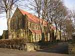
| Church of All Saints |
Elland |
Church |
1896 |
01983-06-06-00006 June 1983 |
SE1075020462
53°40′50″N 1°50′19″W / 53.680512°N 1.838727°W / 53.680512; -1.838727 (Church of All Saints) |
1133954 |
More images
|
| The Fleece Inn |
Elland |
House |
1610 !Early 17th century |
01968-01-24-000024 January 1968 |
SE1055220998
53°41′07″N 1°50′30″W / 53.685333°N 1.841706°W / 53.685333; -1.841706 (The Fleece Inn) |
1313985 |
More images
|
| Sunny Bank |
Elland |
House |
1650 !17th century |
01968-01-24-000024 January 1968 |
SE0879321204
53°41′14″N 1°52′06″W / 53.687217°N 1.868334°W / 53.687217; -1.868334 (Sunny Bank) |
1133970 |
|
| Church of St Stephen |
Greetland, Elland |
Church |
1863 |
01983-06-06-00006 June 1983 |
SE0847322321
53°41′50″N 1°52′23″W / 53.697262°N 1.873149°W / 53.697262; -1.873149 (Church of St Stephen) |
1133985 |
More images
|
| Clay House |
Greetland, Elland |
Apartment |
1650 !c.1650 |
01968-01-24-000024 January 1968 |
SE0974821445
53°41′22″N 1°51′14″W / 53.689366°N 1.853866°W / 53.689366; -1.853866 (Clay House) |
1184835 |
|
| Clay House Barn |
Elland |
Aisled barn |
1650 !17th century |
01977-11-15-000015 November 1977 |
SE0977621470
53°41′23″N 1°51′12″W / 53.68959°N 1.853441°W / 53.68959; -1.853441 (Clay House Barn) |
1133992 |
|
| Field House |
Sowerby |
House |
1749 |
01966-11-15-000015 November 1966 |
SE0415422639
53°42′01″N 1°56′19″W / 53.700171°N 1.938558°W / 53.700171; -1.938558 (Field House) |
1313736 |
|
| The Wet Dock |
Sowerby Bridge Canal Basin, Sowerby |
Canal |
1775 !c.1775 |
01975-10-17-000017 October 1975 |
SE0653223713
53°42′35″N 1°54′09″W / 53.709801°N 1.902518°W / 53.709801; -1.902518 (The Wet Dock) |
1313744 |
|
| 52 and 54 Town Gate |
Sowerby |
House |
1662 |
01966-11-15-000015 November 1966 |
SE0399423283
53°42′21″N 1°56′28″W / 53.705961°N 1.940974°W / 53.705961; -1.940974 (52 and 54 Town Gate) |
1319946 |
|
| Former lockup |
Illingworth, Calderdale |
House |
1823 |
01954-11-03-00003 November 1954 |
SE0707728395
53°45′07″N 1°53′39″W / 53.751876°N 1.894156°W / 53.751876; -1.894156 (Former lockup) |
1314017 |
|
| Giles House |
Brighouse |
House |
1655 |
01967-01-03-00003 January 1967 |
SE1347224594
53°43′03″N 1°47′50″W / 53.717588°N 1.797339°W / 53.717588; -1.797339 (Giles House) |
1300213 |
|
| Haugh End House |
Sowerby |
House |
1751 !Mid-18th century |
01966-11-16-000016 November 1966 |
SE0528623104
53°42′16″N 1°55′17″W / 53.704341°N 1.921405°W / 53.704341; -1.921405 (Haugh End House) |
1184180 |
|
| Highley Hall and Barn |
Clifton |
House |
1632 |
01967-01-03-00003 January 1967 |
SE1595722979
53°42′11″N 1°45′35″W / 53.703003°N 1.759767°W / 53.703003; -1.759767 (Highley Hall and Barn) |
1314067 |
|
| Holdsworth House with wall and gateway to forecourt |
Calderdale |
House |
1633 |
01954-11-03-00003 November 1954 |
SE0832229052
53°45′28″N 1°52′31″W / 53.757763°N 1.875258°W / 53.757763; -1.875258 (Holdsworth House with wall and gateway to forecourt) |
1133873 |
|
| Gazebo to Holdsworth House |
Calderdale |
Gazebo |
1650 !17th century |
01954-11-03-00003 November 1954 |
SE0828529038
53°45′27″N 1°52′33″W / 53.757637°N 1.875819°W / 53.757637; -1.875819 (Gazebo to Holdsworth House) |
1133874 |
|
| Lower Field Bottom Farmhouse |
Shelf |
House |
1490 !Late 15th century |
01966-08-09-00009 August 1966 |
SE1244627423
53°44′35″N 1°48′46″W / 53.74304°N 1.812773°W / 53.74304; -1.812773 (Lower Field Bottom Farmhouse) |
1314057 |
|
| Lower Fold Farmhouse |
Shelf |
House |
1651 !Mid-17th century |
01956-11-01-00001 November 1956 |
SE1320328484
53°45′09″N 1°48′05″W / 53.752558°N 1.801251°W / 53.752558; -1.801251 (Lower Fold Farmhouse) |
1133767 |
|
| Lower Old Hall and Lower Old Hall Cottage |
Norland |
House |
1634 |
01966-11-15-000015 November 1966 |
SE0693122973
53°42′11″N 1°53′47″W / 53.703144°N 1.896489°W / 53.703144; -1.896489 (Lower Old Hall and Lower Old Hall Cottage) |
1184892 |
|
| Lumb Mill |
Wainstalls |
Cotton mill |
1803 |
01998-05-20-000020 May 1998 |
SE0470428866
53°45′22″N 1°55′48″W / 53.756135°N 1.930135°W / 53.756135; -1.930135 (Lumb Mill) |
1119751 |
|
| Marlborough Hall |
Halifax |
Shop |
1875 !Mid/later 19th century |
01973-11-23-000023 November 1973 |
SE0926925268
53°43′25″N 1°51′40″W / 53.723736°N 1.861006°W / 53.723736; -1.861006 (Marlborough Hall) |
1314023 |
|
| Marsh Hall |
Northowram |
House |
1626 !Dated 1626 |
01954-11-03-00003 November 1954 |
SE1082427839
53°44′49″N 1°50′14″W / 53.746815°N 1.837351°W / 53.746815; -1.837351 (Marsh Hall) |
1203782 |
|
| Mount Sion Methodist Church and House attached |
Illingworth |
Chapel |
1773 |
01973-11-23-000023 November 1973 |
SE0680329695
53°45′49″N 1°53′54″W / 53.763564°N 1.898283°W / 53.763564; -1.898283 (Mount Sion Methodist Church and House attached) |
1254018 |
|
| No. 39, Albany Club and two pairs of gate piers to forecourt |
Halifax |
House |
1875 !Mid/Later 18th century |
01954-11-03-00003 November 1954 |
SE0945424682
53°43′06″N 1°51′30″W / 53.718466°N 1.85822°W / 53.718466; -1.85822 (No. 39, Albany Club and two pairs of gate piers to forecourt) |
1314020 |
|
| Old Lane Mill, or Rawson's Mill |
Halifax |
Fireproof factory |
1828 !1825–28 |
01994-04-12-000012 April 1994 |
SE0861726341
53°44′00″N 1°52′15″W / 53.733391°N 1.870858°W / 53.733391; -1.870858 (Old Lane Mill, or Rawson's Mill) |
1244144 |
More images
|
| Former boiler house and attached chimney to north of Old Lane Mill |
Halifax |
Boiler house |
1828 !1827–28 |
01994-04-12-000012 April 1994 |
SE0860826394
53°44′02″N 1°52′16″W / 53.733868°N 1.870993°W / 53.733868; -1.870993 (Former boiler house and attached chimney to north of Old Lane Mill) |
1272533 |
More images
|
| Ovenden Hall |
Ovenden |
House |
1675 !Later 17th century |
01954-11-03-00003 November 1954 |
SE0827527022
53°44′22″N 1°52′34″W / 53.739518°N 1.876024°W / 53.739518; -1.876024 (Ovenden Hall) |
1242456 |
|
| Scout Hall |
Calderdale |
House |
1675 !Later 17th century |
01954-11-03-00003 November 1954 |
SE0949927708
53°44′44″N 1°51′27″W / 53.745663°N 1.857447°W / 53.745663; -1.857447 (Scout Hall) |
1203783 |
|
| Two-cell house, Home Farm building number 6 |
Kirklees Park |
House |
1610 !Early 17th century |
01967-01-03-00003 January 1967 |
SE1743122202
53°41′45″N 1°44′15″W / 53.695972°N 1.737483°W / 53.695972; -1.737483 (Two-cell house, Home Farm building number 6) |
1314059 |
|
| Home Farm building number 7, L-shaped aisled barn |
Kirklees Park |
Cow house |
1510 !Early 16th century |
01967-01-03-00003 January 1967 |
SE1745222190
53°41′45″N 1°44′14″W / 53.695863°N 1.737166°W / 53.695863; -1.737166 (Home Farm building number 7, L-shaped aisled barn) |
1133808 |
|
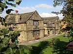
| Kirklees Priory Gatehouse |
Kirklees Park |
Gatehouse |
1510 !Early 16th century |
01967-01-03-00003 January 1967 |
SE1745022110
53°41′43″N 1°44′14″W / 53.695145°N 1.737201°W / 53.695145; -1.737201 (Kirklees Priory Gatehouse) |
1314039 |
|
| Single-aisled cow house |
Kirklees Park |
Cow house |
1610 !Early 17th century |
01967-01-03-00003 January 1967 |
SE1746222159
53°41′44″N 1°44′13″W / 53.695585°N 1.737016°W / 53.695585; -1.737016 (Single-aisled cow house) |
1133805 |
|
| Well Head |
Halifax |
House |
1775 !Later 18th century |
01954-11-03-00003 November 1954 |
SE0909224535
53°43′02″N 1°51′49″W / 53.717151°N 1.86371°W / 53.717151; -1.86371 (Well Head) |
1259124 |
|
| 1 and 3 Upper Green Lane |
Calderdale |
House |
1690 !Late 17th century |
01983-12-02-00002 December 1983 |
SE1351024315
53°42′54″N 1°47′48″W / 53.715079°N 1.796775°W / 53.715079; -1.796775 (1 and 3 Upper Green Lane) |
1314090 |
|
.jpg)

.jpg)
.jpg)
.jpg)


.jpg)
.jpg)
.jpg)

.jpg)


.jpg)