| Name |
Location |
Type |
Completed | Date designated |
Grid ref.
Geo-coordinates |
Entry number | Image |
|
|
| Range of outbuildings and stables, and walls enclosing a courtyard to south of Hardwick Hall |
Hardwick Park, Ault Hucknall |
Stables |
1600 !17th century |
01966-07-08-00008 July 1966 |
SK4636263478
53°09′59″N 1°18′29″W / 53.166409°N 1.30797°W / 53.166409; -1.30797 (Range of outbuildings and stables, and walls enclosing a courtyard to south of Hardwick Hall) |
1051634 |
|
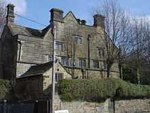
| Barlborough Old Hall |
Barlborough |
Manor house |
1600 !17th century |
01965-08-26-000026 August 1965 |
SK4764577296
53°17′26″N 1°17′12″W / 53.290494°N 1.28672°W / 53.290494; -1.28672 (Barlborough Old Hall) |
1335416 |

|
| Beightonfields Priory |
Barlborough |
Country house |
1600 !17th century |
01965-08-26-000026 August 1965 |
SK4559276749
53°17′09″N 1°19′03″W / 53.285758°N 1.317594°W / 53.285758; -1.317594 (Beightonfields Priory) |
1052227 |
|
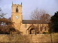
| Church of St James |
Barlborough |
Church |
1100 !12th century |
01965-08-26-000026 August 1965 |
SK4769677188
53°17′22″N 1°17′09″W / 53.289519°N 1.285971°W / 53.289519; -1.285971 (Church of St James) |
1335412 |
|
| Gazebo at Barlborough Hall |
Barlborough |
Gazebo |
1600 !17th century |
01989-03-23-000023 March 1989 |
SK4765278265
53°17′57″N 1°17′11″W / 53.299203°N 1.28647°W / 53.299203; -1.28647 (Gazebo at Barlborough Hall) |
1367143 |
|
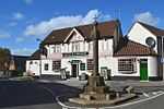
| Village Cross |
Barlborough |
Cross |
1300 !14th century |
01965-08-26-000026 August 1965 |
SK4761677277
53°17′25″N 1°17′14″W / 53.290326°N 1.287158°W / 53.290326; -1.287158 (Village Cross) |
1039862 |
|
| Newton Old Hall |
Blackwell |
House |
1650 !Mid 17th century |
01951-07-11-000011 July 1951 |
SK4438459217
53°07′42″N 1°20′17″W / 53.128278°N 1.338144°W / 53.128278; -1.338144 (Newton Old Hall) |
1367111 |
|
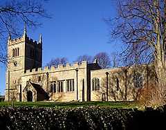
| Church of St John the Baptist |
Clowne |
Church |
1100 !12th century |
01965-08-26-000026 August 1965 |
SK4982875294
53°16′20″N 1°15′15″W / 53.2723°N 1.254288°W / 53.2723; -1.254288 (Church of St John the Baptist) |
1040039 |
More images
|
| Clowne Cross |
Clowne |
Market cross |
1300 !14th century |
01965-08-26-000026 August 1965 |
SK4914875437
53°16′25″N 1°15′52″W / 53.273649°N 1.264462°W / 53.273649; -1.264462 (Clowne Cross) |
1108957 |
|
| Church of St Peter |
Elmton |
Church |
1900 !20th century |
01965-08-26-000026 August 1965 |
SK5026573452
53°15′21″N 1°14′53″W / 53.255703°N 1.248026°W / 53.255703; -1.248026 (Church of St Peter) |
1335410 |
More images
|
| Church of the Holy Cross |
Langwith |
Church |
1200 !13th century |
01966-07-08-00008 July 1966 |
SK5187869331
53°13′07″N 1°13′28″W / 53.218509°N 1.224521°W / 53.218509; -1.224521 (Church of the Holy Cross) |
1335434 |
|
| Church of St Mary and St Lawrence |
Old Bolsover |
Church |
1200 !13th century |
01965-07-05-00005 July 1965 |
SK4744270306
53°13′40″N 1°17′27″W / 53.227686°N 1.290805°W / 53.227686; -1.290805 (Church of St Mary and St Lawrence) |
1054045 |
|
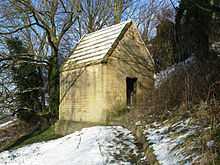
| Conduit house |
Old Bolsover |
Conduit house |
1600 !17th century |
01965-07-05-00005 July 1965 |
SK4755969987
53°13′29″N 1°17′21″W / 53.2248°N 1.2891°W / 53.2248; -1.2891 (Conduit house) |
1108954 |
|
| Conduit house |
Old Bolsover |
Conduit house |
1600 !17th century |
01965-07-05-00005 July 1965 |
SK4716270440
53°13′44″N 1°17′42″W / 53.228915°N 1.294979°W / 53.228915; -1.294979 (Conduit house) |
1054750 |
|
| Conduit house to rear of Number 85 |
Old Bolsover |
Conduit house |
1600 !17th century |
01965-07-05-00005 July 1965 |
SK4745670116
53°13′34″N 1°17′26″W / 53.225977°N 1.290623°W / 53.225977; -1.290623 (Conduit house to rear of Number 85) |
1372046 |
|
| Conduit house to south-east of St Bernadette's Church |
Old Bolsover |
Conduit House |
1600 !17th century |
01965-07-05-00005 July 1965 |
SK4733970250
53°13′38″N 1°17′32″W / 53.227191°N 1.292356°W / 53.227191; -1.292356 (Conduit house to south-east of St Bernadette's Church) |
1108981 |
|
| The Cundy House |
Old Bolsover |
Conduit house |
1600 !17th century |
01989-03-23-000023 March 1989 |
SK4712370917
53°14′00″N 1°17′44″W / 53.233206°N 1.295493°W / 53.233206; -1.295493 (The Cundy House) |
1367442 |
|
| Church of St Michael |
Pleasley |
Church |
1100 !12th century |
01966-07-08-00008 July 1966 |
SK5042864572
53°10′33″N 1°14′49″W / 53.175874°N 1.246984°W / 53.175874; -1.246984 (Church of St Michael) |
1108926 |
|
| Church of St Leonard |
Scarcliffe |
Church |
1100 !12th century |
01966-07-08-00008 July 1966 |
SK4954368750
53°12′49″N 1°15′34″W / 53.213509°N 1.259577°W / 53.213509; -1.259577 (Church of St Leonard) |
1054908 |
More images
|
| Carnfield Hall |
South Normanton |
House |
1599 !Early 17th century |
01951-07-11-000011 July 1951 |
SK4257056044
53°06′00″N 1°21′56″W / 53.099905°N 1.365671°W / 53.099905; -1.365671 (Carnfield Hall) |
1367071 |
|
| Church of St Michael |
South Normanton |
Church |
1200 !13th century |
01966-07-08-00008 July 1966 |
SK4422256961
53°06′29″N 1°20′27″W / 53.108014°N 1.340875°W / 53.108014; -1.340875 (Church of St Michael) |
1108933 |
|
| Park Hall |
Spinkhill |
Country house |
1600 !17th century |
01965-08-26-000026 August 1965 |
SK4626478794
53°18′15″N 1°18′26″W / 53.30408°N 1.307217°W / 53.30408; -1.307217 (Park Hall) |
1372089 |
|
| Whitwell Hall |
Whitwell |
Manor house |
1600 !17th century |
01951-11-19-000019 November 1951 |
SK5260976914
53°17′12″N 1°12′44″W / 53.286592°N 1.212324°W / 53.286592; -1.212324 (Whitwell Hall) |
1055849 |
|