| Name |
Location |
Type |
Completed | Date designated |
Grid ref.
Geo-coordinates |
Entry number | Image |
|
|
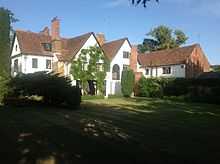
| Avenue House |
Ampthill |
House |
1775 |
01951-07-17-000017 July 1951 |
TL0355238180
52°01′57″N 0°29′31″W / 52.03237°N 0.491932°W / 52.03237; -0.491932 (Avenue House) |
1114436 |

|
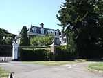
| Dynevor House |
Ampthill |
Country house |
1725 |
01951-07-17-000017 July 1951 |
TL0368438229
52°01′58″N 0°29′24″W / 52.032786°N 0.489994°W / 52.032786; -0.489994 (Dynevor House) |
1137916 |
|
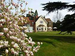
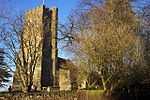
| Ampthill Park House |
Ampthill |
Country house |
1694 |
01951-07-17-000017 July 1951 |
TL0267039058
52°02′26″N 0°30′16″W / 52.040425°N 0.504521°W / 52.040425; -0.504521 (Ampthill Park House) |
1137595 |
More images
|
| 37 Church Street |
Ampthill |
House |
1710 !Early 18th century |
01951-07-17-000017 July 1951 |
TL0364438178
52°01′56″N 0°29′26″W / 52.032335°N 0.490592°W / 52.032335; -0.490592 (37 Church Street) |
1321441 |
|
| Aspley House |
Aspley Guise |
Country house |
Pre-1749 |
01952-10-22-000022 October 1952 |
SP9436836094
52°00′55″N 0°37′35″W / 52.015258°N 0.626338°W / 52.015258; -0.626338 (Aspley House) |
1113948 |
|
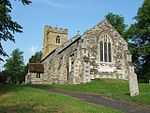
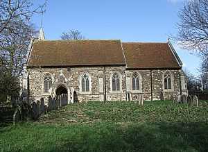
| Church of St Botolph |
Aspley Guise |
Parish church |
Medieval |
01961-01-23-000023 January 1961 |
SP9424936248
52°01′00″N 0°37′41″W / 52.016662°N 0.628029°W / 52.016662; -0.628029 (Church of St Botolph) |
1312070 |
|
| Guise House |
Aspley Guise |
Country house |
1710 !Early 18th century |
01961-01-23-000023 January 1961 |
SP9428636077
52°00′54″N 0°37′39″W / 52.015119°N 0.627537°W / 52.015119; -0.627537 (Guise House) |
1113952 |
|
| The Old House |
Aspley Guise |
House |
1810 !Early 19th century |
01952-10-22-000022 October 1952 |
SP9440036218
52°00′59″N 0°37′33″W / 52.016367°N 0.625838°W / 52.016367; -0.625838 (The Old House) |
1113954 |
|
| Church of Saint Michael |
Aspley Heath |
Parish church |
1868 |
01972-03-01-00001 March 1972 |
SP9285835343
52°00′32″N 0°38′55″W / 52.008762°N 0.648538°W / 52.008762; -0.648538 (Church of Saint Michael) |
1312016 |
More images
|
| Church of Saint Guthlac |
Astwick |
Parish church |
1450 !15th century |
01966-10-31-000031 October 1966 |
TL2134938566
52°01′56″N 0°13′57″W / 52.032235°N 0.232492°W / 52.032235; -0.232492 (Church of Saint Guthlac) |
1113827 |
More images
|
| Church of St Andrew |
Biggleswade |
Parish church |
1350 !14th century |
01952-05-20-000020 May 1952 |
TL1880144602
52°05′13″N 0°16′03″W / 52.087028°N 0.267518°W / 52.087028; -0.267518 (Church of St Andrew) |
1321424 |
|
| Church of All Saints |
Caddington |
Church |
1190 !Late 12th century |
01967-02-03-00003 February 1967 |
TL0639819847
51°52′01″N 0°27′22″W / 51.867064°N 0.456131°W / 51.867064; -0.456131 (Church of All Saints) |
1321349 |
|
| Campton Manor |
Campton, Campton and Chicksands |
House |
1750 !18th century |
01952-01-16-000016 January 1952 |
TL1290537988
52°01′44″N 0°21′21″W / 52.028822°N 0.355715°W / 52.028822; -0.355715 (Campton Manor) |
1137564 |
|
| Orangery approximately 100 metres north-east of Chicksands Priory |
Chicksands, Campton and Chicksands |
Orangery |
1800 !c.1800 |
01973-10-11-000011 October 1973 |
TL1217939414
52°02′30″N 0°21′57″W / 52.041784°N 0.365825°W / 52.041784; -0.365825 (Orangery approximately 100 metres north-east of Chicksands Priory) |
1113727 |
|
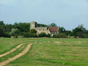
| Parish Church of All Saints |
Campton, Campton and Chicksands |
Parish church |
1290 !Late 13th century |
01966-10-31-000031 October 1966 |
TL1299138069
52°01′46″N 0°21′16″W / 52.029532°N 0.354435°W / 52.029532; -0.354435 (Parish Church of All Saints) |
1113722 |
|
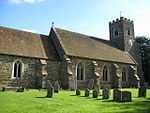
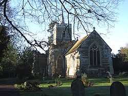
| Church of All Saints |
Clifton |
Parish church |
1310 !Early 14th century |
01966-10-31-000031 October 1966 |
TL1658939249
52°02′22″N 0°18′06″W / 52.039393°N 0.301613°W / 52.039393; -0.301613 (Church of All Saints) |
1321771 |
More images
|
| Church of St Mary the Virgin |
Clophill |
Church |
1400 !14th and 15th century |
01961-01-23-000023 January 1961 |
TL0918938852
52°02′14″N 0°24′34″W / 52.03733°N 0.40958°W / 52.03733; -0.40958 (Church of St Mary the Virgin) |
1113735 |
More images
|
| Chew's House |
Dunstable |
House |
1715 !c.1715 |
01951-10-25-000025 October 1951 |
TL0213221654
51°53′03″N 0°31′03″W / 51.884102°N 0.517531°W / 51.884102; -0.517531 (Chew's House) |
1114595 |
|
| Marshe Almshouses |
Dunstable |
Almshouse |
1743 !c.1743 |
01951-10-25-000025 October 1951 |
TL0218821986
51°53′13″N 0°31′00″W / 51.887076°N 0.51662°W / 51.887076; -0.51662 (Marshe Almshouses) |
1114583 |
|
| Priory House (Council Offices) |
Dunstable |
House |
1750 !18th century |
01951-10-25-000025 October 1951 |
TL0198721774
51°53′07″N 0°31′11″W / 51.885207°N 0.519602°W / 51.885207; -0.519602 (Priory House (Council Offices)) |
1114593 |
|
| 13 High Street North |
Dunstable |
Gatehouse |
1610 !Early 17th century |
01976-03-04-00004 March 1976 |
TL0182821903
51°53′11″N 0°31′19″W / 51.886396°N 0.521873°W / 51.886396; -0.521873 (13 High Street North) |
1114592 |
|
| Church of St Mary |
Dunton |
Church |
1400 !14th and 15th century |
01966-10-31-000031 October 1966 |
TL2373944224
52°04′57″N 0°11′44″W / 52.082551°N 0.195623°W / 52.082551; -0.195623 (Church of St Mary) |
1114060 |
More images
|
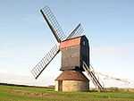
| Doolittle Mill |
Eaton Bray |
House |
1750 !18th century |
01980-09-26-000026 September 1980 |
SP9901320179
51°52′17″N 0°33′48″W / 51.871407°N 0.563254°W / 51.871407; -0.563254 (Doolittle Mill) |
1321286 |
|
| Church of St Michael |
Eggington |
Church |
1310 !Early 14th century |
01967-02-03-00003 February 1967 |
SP9567925171
51°55′01″N 0°36′37″W / 51.916857°N 0.610281°W / 51.916857; -0.610281 (Church of St Michael) |
1158463 |
|
| Eggington House |
Eggington |
House |
1696 !c.1696 |
01952-04-29-000029 April 1952 |
SP9604925356
51°55′06″N 0°36′17″W / 51.918456°N 0.604851°W / 51.918456; -0.604851 (Eggington House) |
1114682 |
|
| Church of Saint John the Baptist |
Church End, Eversholt |
Parish church |
1150 !12th century |
01961-01-23-000023 January 1961 |
SP9829632505
51°58′56″N 0°34′13″W / 51.982319°N 0.570149°W / 51.982319; -0.570149 (Church of Saint John the Baptist) |
1138155 |
More images
|
| Tyrells End Farmhouse |
Tyrells End, Eversholt |
House |
1450 !15th century |
01987-03-16-000016 March 1987 |
SP9821032911
51°59′10″N 0°34′17″W / 51.985984°N 0.571284°W / 51.985984; -0.571284 (Tyrells End Farmhouse) |
1311955 |
|
| Flitwick Manor |
Flitwick |
House |
1620 !Earlier 17th century |
01952-10-22-000022 October 1952 |
TL0291534173
51°59′47″N 0°30′09″W / 51.996475°N 0.502417°W / 51.996475; -0.502417 (Flitwick Manor) |
1137690 |
|
| Parish Church of Saint Giles |
Upper Gravenhurst, Gravenhurst |
Parish church |
1150 !12th century |
01961-01-23-000023 January 1961 |
TL1130535987
52°00′40″N 0°22′47″W / 52.011162°N 0.379676°W / 52.011162; -0.379676 (Parish Church of Saint Giles) |
1113746 |
|
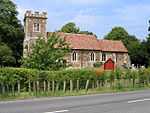
| Church of Saint Michael and All Angels |
Great Billington |
Church |
1250 !13th century |
01967-02-03-00003 February 1967 |
SP9404522557
51°53′37″N 0°38′05″W / 51.89364°N 0.634744°W / 51.89364; -0.634744 (Church of Saint Michael and All Angels) |
1311613 |
More images
|
| Harlington Manor |
Harlington |
House |
1390 !Late 14th century |
01952-10-22-000022 October 1952 |
TL0365330451
51°57′46″N 0°29′34″W / 51.962886°N 0.492795°W / 51.962886; -0.492795 (Harlington Manor) |
1137774 |
More images
|
| Church of Saint Mary the Virgin |
Church End, Haynes |
Parish church |
1350 !14th century |
01961-01-23-000023 January 1961 |
TL0810941190
52°03′31″N 0°25′28″W / 52.058553°N 0.42458°W / 52.058553; -0.42458 (Church of Saint Mary the Virgin) |
1311867 |
More images
|
| Heath Manor |
Heath and Reach |
Manor house |
1600 !Late 16th or early 17th century |
01952-04-29-000029 April 1952 |
SP9252627698
51°56′24″N 0°39′20″W / 51.940103°N 0.655432°W / 51.940103; -0.655432 (Heath Manor) |
1114690 |
|
| Henlow Grange |
Henlow |
Country house |
1751 !Mid-18th century |
01952-01-16-000016 January 1952 |
TL1838938381
52°01′52″N 0°16′32″W / 52.031211°N 0.275682°W / 52.031211; -0.275682 (Henlow Grange) |
1113835 |
|
| Church of Saint Nicholas |
Church End, Hockliffe |
Church |
1350 !14th century |
01967-02-03-00003 February 1967 |
SP9660826968
51°55′58″N 0°35′47″W / 51.932848°N 0.596274°W / 51.932848; -0.596274 (Church of Saint Nicholas) |
1114693 |
|
| 17th-century range of outbuildings to north-west of Houghton Hall |
Houghton Regis |
Outbuilding |
1650 !17th century |
01980-09-26-000026 September 1980 |
TL0217023710
51°54′09″N 0°30′59″W / 51.902574°N 0.516371°W / 51.902574; -0.516371 (17th-century range of outbuildings to north-west of Houghton Hall) |
1114706 |
|
| Houghton Hall |
Houghton Regis |
House |
1690 !Late 17th century |
01952-04-29-000029 April 1952 |
TL0219723695
51°54′09″N 0°30′58″W / 51.902434°N 0.515983°W / 51.902434; -0.515983 (Houghton Hall) |
1321335 |
|
| Crawley House |
Crawley Park, Husborne Crawley |
Country house |
1778 !1777–78 |
01952-10-22-000022 October 1952 |
SP9533036002
52°00′51″N 0°36′44″W / 52.014267°N 0.612351°W / 52.014267; -0.612351 (Crawley House) |
1321680 |
|
| Parish Church of St James |
Husborne Crawley |
Parish church |
1250 !13th century |
01961-01-23-000023 January 1961 |
SP9556536227
52°00′58″N 0°36′32″W / 52.016249°N 0.608865°W / 52.016249; -0.608865 (Parish Church of St James) |
1321642 |
|
| Hyde Mill (including attached granary and store) |
Hyde |
Corn mill |
1890 !Late 19th century |
01998-06-22-000022 June 1998 |
TL1324916995
51°50′24″N 0°21′27″W / 51.840086°N 0.357606°W / 51.840086; -0.357606 (Hyde Mill (including attached granary and store)) |
1119785 |
|
| Luton Hoo Stables, including frontage range and rear courtyard buildings, incorporating stablemaster's house |
Luton Hoo Estate, Hyde |
House |
1810 !Early 19th century |
01967-02-03-00003 February 1967 |
TL1046218212
51°51′06″N 0°23′52″W / 51.851581°N 0.397653°W / 51.851581; -0.397653 (Luton Hoo Stables, including frontage range and rear courtyard buildings, incorporating stablemaster's house) |
1114713 |
|
| The Hyde |
East Hyde Park, Hyde |
House |
1750 !18th century |
01967-02-03-00003 February 1967 |
TL1356017649
51°50′45″N 0°21′10″W / 51.8459°N 0.352879°W / 51.8459; -0.352879 (The Hyde) |
1158916 |
|
| Lynch House |
Kensworth Lynch, Kensworth |
House |
1750 !18th century |
01967-02-03-00003 February 1967 |
TL0441518155
51°51′08″N 0°29′08″W / 51.852231°N 0.48543°W / 51.852231; -0.48543 (Lynch House) |
1114724 |
|
| Library at the Cedars School |
Leighton Buzzard |
Clergy house |
1710 !Early 18th century |
01954-05-27-000027 May 1954 |
SP9184024962
51°54′56″N 0°39′58″W / 51.915624°N 0.666137°W / 51.915624; -0.666137 (Library at the Cedars School) |
1321402 |
|
| Market Cross |
Leighton Buzzard |
Market cross |
1450 !15th century |
01954-05-27-000027 May 1954 |
SP9214025060
51°54′59″N 0°39′42″W / 51.916455°N 0.66175°W / 51.916455; -0.66175 (Market Cross) |
1321381 |
|
| Moat Farmhouse |
Marston Moretaine |
Farmhouse |
1510 !Early 16th century |
01952-10-22-000022 October 1952 |
SP9931041330
52°03′41″N 0°33′10″W / 52.061457°N 0.552832°W / 52.061457; -0.552832 (Moat Farmhouse) |
1114050 |
|
| Church of Saint Mary the Virgin |
Maulden |
Parish church |
1350 !14th century |
01961-01-23-000023 January 1961 |
TL0584138054
52°01′51″N 0°27′31″W / 52.030806°N 0.458617°W / 52.030806; -0.458617 (Church of Saint Mary the Virgin) |
1321701 |
More images
|
| Church of St Mary the Virgin |
Meppershall |
Parish church |
1150 !12th century |
01966-10-31-000031 October 1966 |
TL1345935925
52°00′37″N 0°20′54″W / 52.010169°N 0.348326°W / 52.010169; -0.348326 (Church of St Mary the Virgin) |
1312589 |
More images
|
| St Thomas' Chapel approximately 20 metres south of Chapel Farmhouse |
Meppershall |
Chapel |
1175 !c.1175 |
01966-10-31-000031 October 1966 |
TL1471536215
52°00′45″N 0°19′48″W / 52.012517°N 0.329938°W / 52.012517; -0.329938 (St Thomas' Chapel approximately 20 metres south of Chapel Farmhouse) |
1113845 |
|
| Church of St Michael |
Millbrook |
Parish church |
1250 !13th century |
01961-01-23-000023 January 1961 |
TL0136238528
52°02′09″N 0°31′25″W / 52.035902°N 0.523741°W / 52.035902; -0.523741 (Church of St Michael) |
1113934 |
More images
|
| London Lodge, gateway and walls |
Milton Bryan |
Gate lodge |
1810 !1805–10 |
01961-01-23-000023 January 1961 |
SP9633330890
51°58′05″N 0°35′57″W / 51.968147°N 0.599175°W / 51.968147; -0.599175 (London Lodge, gateway and walls) |
1311905 |
|
| Former principal stable block of Moggerhanger House |
Mogerhanger |
Stable |
1792 !1790–92 |
01985-03-06-00006 March 1985 |
TL1351348640
52°07′28″N 0°20′36″W / 52.124425°N 0.343316°W / 52.124425; -0.343316 (Former principal stable block of Moggerhanger House) |
1113882 |
|
| Dovecote at Ickwell Bury |
Ickwell, Northill |
Dovecote |
1680s |
01966-10-31-000031 October 1966 |
TL1458145657
52°05′51″N 0°19′43″W / 52.097398°N 0.328726°W / 52.097398; -0.328726 (Dovecote at Ickwell Bury) |
1321726 |
|
| Barns at Warden Abbey Farm |
Old Warden |
Barn |
1590 !Late 16th century |
01972-03-16-000016 March 1972 |
TL1195843926
52°04′57″N 0°22′03″W / 52.082378°N 0.367568°W / 52.082378; -0.367568 (Barns at Warden Abbey Farm) |
1274805 |
|
| Bridge between Upper and Middle Ponds |
The Swiss Garden, Old Warden |
Swiss garden |
1890 !Late 19th century |
01973-10-11-000011 October 1973 |
TL1498244757
52°05′21″N 0°19′23″W / 52.089227°N 0.323178°W / 52.089227; -0.323178 (Bridge between Upper and Middle Ponds) |
1222503 |
|
| The Grotto and Fernery |
The Swiss Garden, Old Warden |
Grotto |
1831 !Early 1830s |
01973-10-11-000011 October 1973 |
TL1492144703
52°05′20″N 0°19′27″W / 52.088754°N 0.324086°W / 52.088754; -0.324086 (The Grotto and Fernery) |
1222502 |
|
| Moat bridge south of Middle Pond |
The Swiss Garden, Old Warden |
Swiss garden |
1810 !Early 19th century |
01973-10-11-000011 October 1973 |
TL1496044756
52°05′21″N 0°19′25″W / 52.089222°N 0.323499°W / 52.089222; -0.323499 (Moat bridge south of Middle Pond) |
1274616 |
|
| Old Warden Park (Shuttleworth College) |
Old Warden |
House |
Earlier |
01985-03-06-00006 March 1985 |
TL1464444236
52°05′05″N 0°19′42″W / 52.084615°N 0.328284°W / 52.084615; -0.328284 (Old Warden Park (Shuttleworth College)) |
1222169 |
|
| The Indian Kiosk |
The Swiss Garden, Old Warden |
Garden house |
1810 !Early 19th century |
01973-10-11-000011 October 1973 |
TL1493944790
52°05′22″N 0°19′26″W / 52.089532°N 0.323794°W / 52.089532; -0.323794 (The Indian Kiosk) |
1237794 |
|
| The North Bridge north of Middle Pond |
The Swiss Garden, Old Warden |
Swiss garden |
1810 !Early 19th century |
01973-10-11-000011 October 1973 |
TL1496244804
52°05′23″N 0°19′24″W / 52.089653°N 0.323454°W / 52.089653; -0.323454 (The North Bridge north of Middle Pond) |
1222504 |
|
| The Swiss Cottage |
The Swiss Garden, Old Warden |
Garden house |
1820s |
01973-10-11-000011 October 1973 |
TL1491344653
52°05′18″N 0°19′27″W / 52.088306°N 0.324219°W / 52.088306; -0.324219 (The Swiss Cottage) |
1237818 |
|
| Church of Saint Mary the Virgin |
Potsgrove |
Parish church |
1350 !14th century |
01952-10-22-000022 October 1952 |
SP9515529851
51°57′32″N 0°37′00″W / 51.959011°N 0.616604°W / 51.959011; -0.616604 (Church of Saint Mary the Virgin) |
1321686 |
More images
|
| Church of St James |
Pulloxhill |
Church |
1350 !14th century |
01961-01-23-000023 January 1961 |
TL0616233800
51°59′33″N 0°27′19″W / 51.992513°N 0.455257°W / 51.992513; -0.455257 (Church of St James) |
1138002 |
|
| Old Church of All Saints |
Segenhoe, Ridgmont |
Parish church |
1150 !12th century |
01961-01-23-000023 January 1961 |
SP9811935789
52°00′43″N 0°34′18″W / 52.011867°N 0.571786°W / 52.011867; -0.571786 (Old Church of All Saints) |
|
More images
|
| Parish Church of All Saints |
Ridgmont |
Parish church |
1855 !1854–55 |
01961-01-23-000023 January 1961 |
SP9758736057
52°00′52″N 0°34′46″W / 52.014369°N 0.579459°W / 52.014369; -0.579459 (Parish Church of All Saints) |
1114055 |
More images
|
| Segenhoe Manor |
Segenhoe, Ridgmont |
House |
1710 !Early 18th century |
01993-05-12-000012 May 1993 |
SP9825935995
52°00′49″N 0°34′11″W / 52.013694°N 0.569688°W / 52.013694; -0.569688 (Segenhoe Manor) |
1158084 |
|
| Church of St Swithun |
Sandy |
Church |
Medieval |
01979-12-21-000021 December 1979 |
TL1739349071
52°07′39″N 0°17′11″W / 52.127489°N 0.286519°W / 52.127489; -0.286519 (Church of St Swithun) |
1137790 |
|
| Hazells Hall |
Sandy |
Country house |
1725 !1720s |
01979-05-29-000029 May 1979 |
TL1892049999
52°08′08″N 0°15′50″W / 52.135502°N 0.263899°W / 52.135502; -0.263899 (Hazells Hall) |
1137713 |
|
| Catholic Church of St Francis of Assisi |
Shefford |
Roman Catholic church |
1884 |
01985-01-10-000010 January 1985 |
TL1426039011
52°02′16″N 0°20′08″W / 52.037738°N 0.335632°W / 52.037738; -0.335632 (Catholic Church of St Francis of Assisi) |
1113767 |
|
| Parish Church of Saint Margaret |
Higham Gobion, Shillington |
Parish church |
1350 !14th century |
01961-01-23-000023 January 1961 |
TL1037832784
51°58′57″N 0°23′39″W / 51.982561°N 0.394207°W / 51.982561; -0.394207 (Parish Church of Saint Margaret) |
1113758 |
|
| Bath house and cascade |
Wrest Park, Silsoe |
Bath house |
1771 !c.1769–71 |
01985-01-10-000010 January 1985 |
TL0888535350
52°00′21″N 0°24′54″W / 52.005916°N 0.415123°W / 52.005916; -0.415123 (Bath house and cascade) |
1113790 |
|
| Bowling Green House and two urns on pedestals 5m to the south-east and north-east |
Wrest Park, Silsoe |
Pavilion |
1735 !c.1735 |
01985-01-10-000010 January 1985 |
TL0896635110
49°46′01″N 7°33′26″W / 49.766806°N 7.55716°W / 49.766806; -7.55716 (Bowling Green House and two urns on pedestals 5m to the south-east and north-east) |
1158672 |
More images
|
| Four statuary groups in the South Parterre (also known as the French Garden) south of Wrest House, depicting Aeneas and Anchises, the Abduction of Helen of Troy, Venus and Adonis and Meleager and Atalanta |
Wrest Park, Silsoe |
Statue |
1730 !c.1730 |
01985-01-10-000010 January 1985 |
TL0909535532
52°00′27″N 0°24′43″W / 52.007511°N 0.412007°W / 52.007511; -0.412007 (Four statuary groups in the South Parterre (also known as the French Garden) south of Wrest House, depicting Aeneas and Anchises, the Abduction of Helen of Troy, Venus and Adonis and Meleager and Atalanta) |
1113789 |
|
| Group of five altars approximately 50m south of Ladies Lake |
Wrest Park, Silsoe |
Altar |
-150 !1st–2nd century BCE |
01985-01-10-000010 January 1985 |
TL0930635022
52°00′10″N 0°24′33″W / 52.002886°N 0.409097°W / 52.002886; -0.409097 (Group of five altars approximately 50m south of Ladies Lake) |
1311237 |
|
| Mithraic altar approximately 40m east of the Hutton Monument |
Wrest Park, Silsoe |
Garden ornament |
1748 |
01985-01-10-000010 January 1985 |
TL0906734723
52°00′01″N 0°24′46″W / 52.000246°N 0.412672°W / 52.000246; -0.412672 (Mithraic altar approximately 40m east of the Hutton Monument) |
1158808 |
|
| Orangery, steps and four cherub statues on pedestals |
Wrest Park, Silsoe |
Orangery |
1835 !c.1835 |
01985-01-10-000010 January 1985 |
TL0896935360
52°00′22″N 0°24′50″W / 52.00599°N 0.413897°W / 52.00599; -0.413897 (Orangery, steps and four cherub statues on pedestals) |
1158549 |
More images
|
| Statue of Lady Jemima, 27m South of the West Half House |
Wrest Park, Silsoe |
Statue |
1748 !Erected c.1748 |
01985-01-10-000010 January 1985 |
TL0903634879
52°00′06″N 0°24′47″W / 52.001654°N 0.413074°W / 52.001654; -0.413074 (Statue of Lady Jemima, 27m South of the West Half House) |
1113805 |
|
| Statue of William III 30m north of the Archer Pavilion |
Wrest Park, Silsoe |
Statue |
1730s |
01985-01-10-000010 January 1985 |
TL0918034782
52°00′03″N 0°24′40″W / 52.000754°N 0.411008°W / 52.000754; -0.411008 (Statue of William III 30m north of the Archer Pavilion) |
1158878 |
|
| Parish Church of All Saints |
Southill |
Church |
1814 |
01966-10-31-000031 October 1966 |
TL1458742231
52°04′00″N 0°19′47″W / 52.066608°N 0.329788°W / 52.066608; -0.329788 (Parish Church of All Saints) |
1274447 |
|
| The Temple |
Southill Park, Southill |
Garden building |
1800 !c.1800 |
01952-01-16-000016 January 1952 |
TL1449143179
52°04′31″N 0°19′51″W / 52.075147°N 0.33087°W / 52.075147; -0.33087 (The Temple) |
1237890 |
|
| Church of St Mary the Virgin |
Stotfold |
Parish church |
1150 !12th century |
01966-10-31-000031 October 1966 |
TL2202936680
52°00′54″N 0°13′24″W / 52.015137°N 0.223256°W / 52.015137; -0.223256 (Church of St Mary the Virgin) |
1113866 |
|
| Packhorse Bridge |
Sutton |
Bridge |
1750 !18th century |
01966-10-31-000031 October 1966 |
TL2205847423
52°06′42″N 0°13′08″W / 52.11167°N 0.218997°W / 52.11167; -0.218997 (Packhorse Bridge) |
1321630 |
More images
|
| Church of St Peter |
Tempsford |
Parish church |
1350 !14th century |
01966-10-31-000031 October 1966 |
TL1619253032
52°09′48″N 0°18′10″W / 52.163338°N 0.302702°W / 52.163338; -0.302702 (Church of St Peter) |
1114096 |
|
| Gatehouse to Manor Farm |
Tilsworth |
Gatehouse |
1450 !15th century |
01952-04-29-000029 April 1952 |
SP9761624201
51°54′28″N 0°34′57″W / 51.907803°N 0.582402°W / 51.907803; -0.582402 (Gatehouse to Manor Farm) |
1114739 |
|
| Church of Saint Mary Magdalen |
Westoning |
Parish church |
1150 !12th century |
01961-01-23-000023 January 1961 |
TL0281232792
51°59′03″N 0°30′16″W / 51.984083°N 0.50433°W / 51.984083; -0.50433 (Church of Saint Mary Magdalen) |
1138118 |
|
| Church of St Mary Magdalen |
Whipsnade |
Church |
1450 !15th century |
01967-02-03-00003 February 1967 |
TL0117217959
51°51′04″N 0°31′57″W / 51.851066°N 0.532555°W / 51.851066; -0.532555 (Church of St Mary Magdalen) |
1159770 |
|
| Elephant House |
Whipsnade Zoo, Whipsnade |
Elephant house |
1935 |
01988-09-01-00001 September 1988 |
TL0031617319
51°50′44″N 0°32′43″W / 51.845468°N 0.545164°W / 51.845468; -0.545164 (Elephant House) |
1235411 |
|
| Holly Frindle Bungalow |
Whipsnade Zoo, Whipsnade |
Bungalow |
1936 !1933–36 |
01988-09-01-00001 September 1988 |
TL0002516903
51°50′30″N 0°32′58″W / 51.841781°N 0.549507°W / 51.841781; -0.549507 (Holly Frindle Bungalow) |
1321291 |
|
| Atrium Antiques |
Woburn |
House |
1725 !c.1725 |
01952-10-22-000022 October 1952 |
SP9489233158
51°59′20″N 0°37′10″W / 51.98878°N 0.619517°W / 51.98878; -0.619517 (Atrium Antiques) |
1114002 |
|
| Chinese Pavilion, at centre of maze |
Woburn Park, Woburn |
Garden building |
1833 !c.1833 |
01961-01-23-000023 January 1961 |
SP9671132292
51°58′50″N 0°35′36″W / 51.980683°N 0.59328°W / 51.980683; -0.59328 (Chinese Pavilion, at centre of maze) |
1158303 |
|
| Church of Saint Mary |
Woburn |
Parish church |
1868 !1865–68 |
01972-03-01-00001 March 1972 |
SP9504033273
51°59′23″N 0°37′02″W / 51.989788°N 0.617331°W / 51.989788; -0.617331 (Church of Saint Mary) |
1321663 |
|
| North gatepier of pair adjacent to Lion Lodge |
Woburn Park, Woburn |
Gate pier |
1751 !Mid-18th century |
01961-01-23-000023 January 1961 |
SP9517833297
51°59′24″N 0°36′55″W / 51.98998°N 0.615315°W / 51.98998; -0.615315 (North gatepier of pair adjacent to Lion Lodge) |
1321664 |
|
| Old Church of St Mary |
Woburn |
Parish church |
1868 !1865–68 |
01961-01-23-000023 January 1961 |
SP9486633246
51°59′22″N 0°37′12″W / 51.989575°N 0.619871°W / 51.989575; -0.619871 (Old Church of St Mary) |
1146524 |
|
| South Gatepier of Pair Adjacent to Lion Lodge |
Woburn Park, Woburn |
Gate pier |
1751 !Mid-18th century |
01961-01-23-000023 January 1961 |
SP9518233290
51°59′24″N 0°36′55″W / 51.989917°N 0.615259°W / 51.989917; -0.615259 (South Gatepier of Pair Adjacent to Lion Lodge) |
1114005 |
|
| The Chestnuts |
Woburn |
House |
1790 !Late 18th century |
01952-10-22-000022 October 1952 |
SP9496433063
51°59′16″N 0°37′07″W / 51.987914°N 0.618495°W / 51.987914; -0.618495 (The Chestnuts) |
1113991 |
|
| The Gifford Gallery/Woburn Fine Arts |
Woburn |
House |
1710 !Early 18th century |
01952-10-22-000022 October 1952 |
SP9493433194
51°59′21″N 0°37′08″W / 51.989096°N 0.618896°W / 51.989096; -0.618896 (The Gifford Gallery/Woburn Fine Arts) |
1157988 |
|
| The Grotto |
Woburn Park, Woburn |
Grotto |
1839 !c.1839 |
01961-01-23-000023 January 1961 |
SP9669032654
51°59′02″N 0°35′37″W / 51.98394°N 0.593484°W / 51.98394; -0.593484 (The Grotto) |
1114010 |
|
| The Old Parsonage |
Woburn |
House |
1751 !Mid-18th century |
01952-10-22-000022 October 1952 |
SP9489633231
51°59′22″N 0°37′10″W / 51.989435°N 0.619439°W / 51.989435; -0.619439 (The Old Parsonage) |
1321695 |
|
| The Thornery |
Woburn Park, Woburn |
Cottage ornee |
1808 |
01980-08-04-00004 August 1980 |
SP9718334324
51°59′56″N 0°35′09″W / 51.998864°N 0.585835°W / 51.998864; -0.585835 (The Thornery) |
1158441 |
|
| 4–7 Market Place |
Woburn |
House |
1790 !Late 18th century |
01952-10-22-000022 October 1952 |
SP9493533173
51°59′20″N 0°37′08″W / 51.988907°N 0.618887°W / 51.988907; -0.618887 (4–7 Market Place) |
1157972 |
|


_-_geograph.org.uk_-_136209.jpg)