| Name |
Location |
Type |
Completed | Date designated |
Grid ref.
Geo-coordinates |
Entry number | Image |
|
|
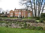
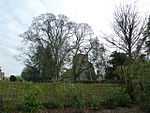
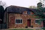
| Hill House |
Ashford Hill with Headley |
Concrete-framed building |
1972 !1970–72 |
02012-12-19-000019 December 2012 |
SU5312462142
51°21′21″N 1°14′19″W / 51.355875°N 1.238473°W / 51.355875; -1.238473 (Hill House) |
1402215 |

|
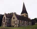
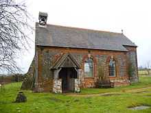
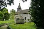
| Church of St Michael |
Crux Easton, Ashmansworth |
Church |
1775 |
01966-05-16-000016 May 1966 |
SU4247856235
51°18′13″N 1°23′31″W / 51.303658°N 1.392052°W / 51.303658; -1.392052 (Church of St Michael) |
1339798 |
More images
|
| Deanes Almshouses |
Basingstoke |
Almshouse |
1607 |
01949-05-03-00003 May 1949 |
SU6397851843
51°15′44″N 1°05′04″W / 51.262165°N 1.084463°W / 51.262165; -1.084463 (Deanes Almshouses) |
1339724 |
|
| Ruins of Chapel of the Holy Ghost |
Basingstoke |
Chapel |
Ruin |
01949-05-03-00003 May 1949 |
SU6355452613
51°16′09″N 1°05′25″W / 51.269135°N 1.090402°W / 51.269135; -1.090402 (Ruins of Chapel of the Holy Ghost) |
1092615 |
More images
|
| Ruins of Chapel of the Holy Trinity |
Basingstoke |
Chapel |
Ruin |
01949-05-03-00003 May 1949 |
SU6358052613
51°16′09″N 1°05′24″W / 51.269132°N 1.090029°W / 51.269132; -1.090029 (Ruins of Chapel of the Holy Trinity) |
1230507 |
More images
|
| St Thomas House (chapel) |
Basingstoke |
Chapel |
1880 !c.1880 |
01984-11-06-00006 November 1984 |
SU6351653093
51°16′24″N 1°05′27″W / 51.273455°N 1.090861°W / 51.273455; -1.090861 (St Thomas House (chapel)) |
1278440 |
|
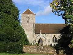
| Church of St Stephen |
Baughurst |
Church |
1845 |
01966-05-16-000016 May 1966 |
SU5821059941
51°20′08″N 1°09′57″W / 51.335589°N 1.1658°W / 51.335589; -1.1658 (Church of St Stephen) |
1092592 |
|
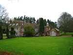
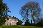
| Wolverton House |
Wolverton Park, Baughurst |
House |
1750 !18th century |
01966-05-16-000016 May 1966 |
SU5536658517
51°19′23″N 1°12′25″W / 51.32307°N 1.206842°W / 51.32307; -1.206842 (Wolverton House) |
1092570 |
|
| Church of All Saints |
Bradley |
Church |
1877 |
01957-04-26-000026 April 1957 |
SU6357541811
51°10′19″N 1°05′31″W / 51.172014°N 1.092013°W / 51.172014; -1.092013 (Church of All Saints) |
1093023 |
|
| Bull Down Farmhouse |
Bramley Green, Bramley |
Farmhouse |
1650 !17th century |
01957-04-26-000026 April 1957 |
SU6631258688
51°19′24″N 1°02′59″W / 51.323439°N 1.049748°W / 51.323439; -1.049748 (Bull Down Farmhouse) |
1156638 |
|
| Earlstone Manor |
Earlstone Common, Burghclere |
Manor house |
1390 !Late 14th century |
01966-05-16-000016 May 1966 |
SU4795459923
51°20′11″N 1°18′47″W / 51.336383°N 1.313012°W / 51.336383; -1.313012 (Earlstone Manor) |
1339721 |
|
| Manor House |
Old Burghclere |
Manor house |
1351 !Mid-14th century |
01984-05-18-000018 May 1984 |
SU4690057889
51°19′05″N 1°19′42″W / 51.318183°N 1.328408°W / 51.318183; -1.328408 (Manor House) |
1092540 |
|
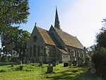
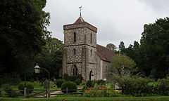
| Church of St Peter |
Brown Candover, Candovers |
Church |
1845 |
01957-04-26-000026 April 1957 |
SU5818839707
51°09′13″N 1°10′10″W / 51.15367°N 1.169399°W / 51.15367; -1.169399 (Church of St Peter) |
1093001 |
More images
|
| Church of All Saints |
Deane |
Church |
1818 |
01984-10-17-000017 October 1984 |
SU5458250237
51°14′55″N 1°13′10″W / 51.2487°N 1.219354°W / 51.2487; -1.219354 (Church of All Saints) |
1179721 |
More images
|
| Church of St Mary |
Sydmonton, Ecchinswell, Sydmonton and Bishops Green |
Former church |
1853 !1849–53 |
01966-05-16-000016 May 1966 |
SU4848657896
51°19′05″N 1°18′20″W / 51.318113°N 1.305651°W / 51.318113; -1.305651 (Church of St Mary) |
1092523 |
|
| Sydmonton Court |
Sydmonton, Ecchinswell, Sydmonton and Bishops Green |
Country house |
1550 !16th century |
01984-05-18-000018 May 1984 |
SU4852457951
51°19′07″N 1°18′18″W / 51.318605°N 1.305098°W / 51.318605; -1.305098 (Sydmonton Court) |
1301426 |
|
| Church of St. Martin |
Ellisfield |
Church |
1250 !13th century |
01957-04-26-000026 April 1957 |
SU6386645892
51°12′31″N 1°05′14″W / 51.208673°N 1.087127°W / 51.208673; -1.087127 (Church of St. Martin) |
1092980 |
More images
|
| Manor Farmhouse |
Ellisfield |
Farmhouse |
1690 !Late 17th century |
01957-04-26-000026 April 1957 |
SU6386745840
51°12′30″N 1°05′14″W / 51.208206°N 1.087122°W / 51.208206; -1.087122 (Manor Farmhouse) |
1092981 |
|
| Church of St. Andrew |
Farleigh Wallop |
Church |
1750 |
01957-04-26-000026 April 1957 |
SU6251747526
51°13′25″N 1°06′22″W / 51.223513°N 1.106151°W / 51.223513; -1.106151 (Church of St. Andrew) |
1302322 |
More images
|
| Farleigh Wallop House |
Farleigh Wallop |
House |
1731 |
01957-04-26-000026 April 1957 |
SU6214446660
51°12′57″N 1°06′42″W / 51.215768°N 1.111641°W / 51.215768; -1.111641 (Farleigh Wallop House) |
1339532 |
|
| Pembrokes |
Hartley Wespall |
House |
1610 !Early 17th century |
01984-10-17-000017 October 1984 |
SU6935358382
51°19′13″N 1°00′22″W / 51.320326°N 1.006173°W / 51.320326; -1.006173 (Pembrokes) |
1178752 |
|
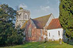
| Church of St. Mary |
Herriard |
Church |
1250 !13th century |
01957-04-26-000026 April 1957 |
SU6637546010
51°12′34″N 1°03′04″W / 51.209449°N 1.051193°W / 51.209449; -1.051193 (Church of St. Mary) |
1339500 |
More images
|
| Church of St Michael Archangel |
Highclere |
Church |
1870 |
01966-05-16-000016 May 1966 |
SU4401760298
51°20′24″N 1°22′10″W / 51.340073°N 1.369477°W / 51.340073; -1.369477 (Church of St Michael Archangel) |
1339760 |
|
| Heaven's Gate |
Highclere Gate, Highclere |
Garden feature |
1751 !Mid-18th century |
01966-05-16-000016 May 1966 |
SU4459657629
51°18′58″N 1°21′41″W / 51.31603°N 1.361499°W / 51.31603; -1.361499 (Heaven's Gate) |
1339737 |
|
| London Lodge |
Highclere Park, Highclere |
Gate |
1793 |
01966-05-16-000016 May 1966 |
SU4587260373
51°20′26″N 1°20′34″W / 51.340601°N 1.342839°W / 51.340601; -1.342839 (London Lodge) |
1166538 |
|
| The Temple |
Highclere Park, Highclere |
Folly |
1760 !c.1760 |
01966-05-16-000016 May 1966 |
SU4555860084
51°20′17″N 1°20′51″W / 51.338027°N 1.347383°W / 51.338027; -1.347383 (The Temple) |
1166518 |
|
| Church of St Andrew |
Hurstbourne Priors |
Church |
1150 !12th century |
01966-05-16-000016 May 1966 |
SU4391846661
51°13′03″N 1°22′21″W / 51.217466°N 1.37257°W / 51.217466; -1.37257 (Church of St Andrew) |
1339806 |
More images
|
| The Bee House |
Hurstbourne Park, Hurstbourne Priors |
House |
1890 !Late 19th century |
01984-05-30-000030 May 1984 |
SU4419846379
51°12′54″N 1°22′07″W / 51.214909°N 1.368596°W / 51.214909; -1.368596 (The Bee House) |
1175623 |
|
| Church of St Mary |
Kingsclere |
Church |
1150 !12th century |
01966-05-16-000016 May 1966 |
SU5252158657
51°19′29″N 1°14′52″W / 51.324598°N 1.247645°W / 51.324598; -1.247645 (Church of St Mary) |
1092447 |
More images
|
| 20 Swan Street |
Kingsclere |
House |
1750 !18th century |
01984-05-18-000018 May 1984 |
SU5247358552
51°19′25″N 1°14′54″W / 51.323658°N 1.248349°W / 51.323658; -1.248349 (20 Swan Street) |
1167623 |
|
| Laverstoke House |
Laverstoke Park, Laverstoke |
House |
1798 |
01953-01-10-000010 January 1953 |
SU4933849054
51°14′19″N 1°17′41″W / 51.238541°N 1.294644°W / 51.238541; -1.294644 (Laverstoke House) |
1339659 |
|
| Church of St James |
Litchfield, Litchfield and Woodcott |
Church |
Norman |
01966-05-16-000016 May 1966 |
SU4616054030
51°17′01″N 1°20′22″W / 51.283546°N 1.339523°W / 51.283546; -1.339523 (Church of St James) |
1308204 |
More images
|
| Church of St. Mary |
Mapledurwell and Up Nately |
Church |
1250 !13th century |
01957-04-26-000026 April 1957 |
SU6874550973
51°15′14″N 1°00′59″W / 51.253789°N 1.01632°W / 51.253789; -1.01632 (Church of St. Mary) |
1092979 |
|
| Church of St. Stephen |
Mapledurwell and Up Nately |
Church |
1200 !c.1200 |
01957-04-26-000026 April 1957 |
SU7006951971
51°15′45″N 0°59′50″W / 51.262601°N 0.997156°W / 51.262601; -0.997156 (Church of St. Stephen) |
1092941 |
More images
|
| Countess of Huntingdon's Chapel |
Mortimer West End |
Chapel |
1805 |
01980-04-25-000025 April 1980 |
SU6166164187
51°22′24″N 1°06′56″W / 51.373401°N 1.115534°W / 51.373401; -1.115534 (Countess of Huntingdon's Chapel) |
1339519 |
|
| Church of St. Leonard |
Oakley |
Church |
1510 !Early 16th century |
01957-04-26-000026 April 1957 |
SU5673350343
51°14′58″N 1°11′19″W / 51.249444°N 1.188522°W / 51.249444; -1.188522 (Church of St. Leonard) |
1301811 |
More images
|
| Barn to south of South Litchfield Grange |
Overton |
Barn |
1650 !17th century |
01984-04-12-000012 April 1984 |
SU5307045855
51°12′34″N 1°14′30″W / 51.209444°N 1.241663°W / 51.209444; -1.241663 (Barn to south of South Litchfield Grange) |
1092664 |
|
| Chapel |
Quidhampton, Overton |
Chapel |
Norman |
01953-01-10-000010 January 1953 |
SU5184150428
51°15′02″N 1°15′31″W / 51.250673°N 1.258595°W / 51.250673; -1.258595 (Chapel) |
1092696 |
|
| Church of St Mary |
Overton |
Church |
1180 !Medieval |
01966-05-16-000016 May 1966 |
SU5146349985
51°14′48″N 1°15′51″W / 51.246724°N 1.264074°W / 51.246724; -1.264074 (Church of St Mary) |
1302540 |
More images
|
| Court Farmhouse |
Overton |
Farmhouse |
1550 !16th century |
01966-05-16-000016 May 1966 |
SU5136449991
51°14′48″N 1°15′56″W / 51.246787°N 1.265492°W / 51.246787; -1.265492 (Court Farmhouse) |
1339662 |
|
| Wyeford Farm House |
Pamber |
Farmhouse |
1610 !Early 17th century |
01957-04-26-000026 April 1957 |
SU5997258885
51°19′33″N 1°08′26″W / 51.325913°N 1.140688°W / 51.325913; -1.140688 (Wyeford Farm House) |
1301155 |
|
| North Hall |
Preston Candover |
House |
1794 |
01957-04-26-000026 April 1957 |
SU6041541578
51°10′13″N 1°08′14″W / 51.170261°N 1.137247°W / 51.170261; -1.137247 (North Hall) |
1092845 |
|
| Remains of the Church of St Mary |
Preston Candover |
Church |
1150 !12th century |
01957-04-26-000026 April 1957 |
SU6036541402
51°10′07″N 1°08′17″W / 51.168684°N 1.137991°W / 51.168684; -1.137991 (Remains of the Church of St Mary) |
1092852 |
More images
|
| Church of St. Nicholas |
Steventon |
Cross |
1250 !13th century |
01957-04-26-000026 April 1957 |
SU5510147226
51°13′18″N 1°12′45″W / 51.221579°N 1.212381°W / 51.221579; -1.212381 (Church of St. Nicholas) |
1092810 |
More images
|
| Bridge over the River Loddon |
Stratfield Saye Park, Stratfield Turgis |
Bridge |
1802 |
01957-04-26-000026 April 1957 |
SU6966961191
51°20′44″N 1°00′04″W / 51.345541°N 1.001091°W / 51.345541; -1.001091 (Bridge over the River Loddon) |
1092776 |
|
| Church of All Saints |
Tunworth |
Church |
1150 !12th century |
01957-04-26-000026 April 1957 |
SU6734248445
51°13′52″N 1°02′13″W / 51.231228°N 1.036896°W / 51.231228; -1.036896 (Church of All Saints) |
1092788 |
More images
|
| Hoddington House |
Hoddington Park, Upton Grey |
House |
1690 !Late 17th century |
01957-04-26-000026 April 1957 |
SU7009247855
51°13′32″N 0°59′51″W / 51.225593°N 0.997631°W / 51.225593; -0.997631 (Hoddington House) |
1092759 |
|
| Church of St. Lawrence |
Weston Patrick |
Church |
1150 !12th century |
01957-04-26-000026 April 1957 |
SU6909446891
51°13′01″N 1°00′44″W / 51.217048°N 1.012106°W / 51.217048; -1.012106 (Church of St. Lawrence) |
1092728 |
|
| Church of All Hallows |
Whitchurch |
Church |
Norman |
01966-05-16-000016 May 1966 |
SU4599447748
51°13′37″N 1°20′34″W / 51.227077°N 1.342709°W / 51.227077; -1.342709 (Church of All Hallows) |
1339652 |
More images
|
| The Silk Mill |
Whitchurch |
Brush factory |
1800 !c.1800 |
01953-01-10-000010 January 1953 |
SU4625547899
51°13′42″N 1°20′20″W / 51.228413°N 1.338952°W / 51.228413; -1.338952 (The Silk Mill) |
1092645 |
More images
|
| Town Hall |
Whitchurch |
Town hall |
1790 !Late 18th century |
01953-01-10-000010 January 1953 |
SU4624348094
51°13′49″N 1°20′21″W / 51.230168°N 1.339099°W / 51.230168; -1.339099 (Town Hall) |
1092680 |
|
| Hackwood House |
Hackwood Park, Winslade |
Country house |
1680 |
01957-04-26-000026 April 1957 |
SU6470049633
51°14′32″N 1°04′28″W / 51.242214°N 1.074515°W / 51.242214; -1.074515 (Hackwood House) |
1092734 |
More images
|
| Stable block and riding school |
Hackwood Park, Winslade |
Courtyard |
1810 !Early 19th century |
01957-04-26-000026 April 1957 |
SU6451449875
51°14′40″N 1°04′38″W / 51.244411°N 1.077136°W / 51.244411; -1.077136 (Stable block and riding school) |
1296483 |
|
| The Menagerie Pond Pavilion |
Hackwood Park (Spring Park), Winslade |
Pavilion |
1750 !18th century |
01957-04-26-000026 April 1957 |
SU6506249464
51°14′26″N 1°04′10″W / 51.240653°N 1.069361°W / 51.240653; -1.069361 (The Menagerie Pond Pavilion) |
1092740 |
|
| Church of St. Lawrence |
Wootton St Lawrence |
Church |
1180 !Norman |
01957-04-26-000026 April 1957 |
SU5921253221
51°16′30″N 1°09′09″W / 51.275068°N 1.152532°W / 51.275068; -1.152532 (Church of St. Lawrence) |
1092711 |
|
| Tangier House |
Wootton St. Lawrence |
House |
1662 |
01957-04-26-000026 April 1957 |
SU5816953161
51°16′29″N 1°10′03″W / 51.274636°N 1.167492°W / 51.274636; -1.167492 (Tangier House) |
1092712 |
|
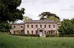
| Worting House |
Worting |
House |
1790 !Late 18th century |
01949-05-03-00003 May 1949 |
SU5994352004
51°15′51″N 1°08′32″W / 51.26405°N 1.142257°W / 51.26405; -1.142257 (Worting House) |
1339701 |
|


_-_geograph.org.uk_-_377290.jpg)