| Name |
Location |
Type |
Completed | Date designated |
Grid ref.
Geo-coordinates |
Entry number | Image |
|
|
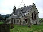
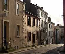
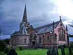
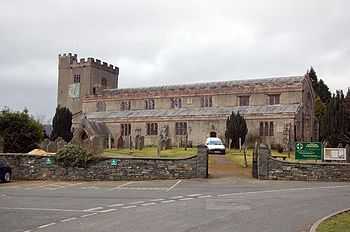
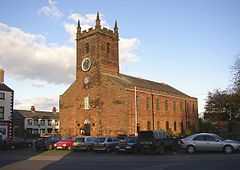
| Church of St Kentigern |
Aspatria |
Church |
1848 !1846–48 |
01967-04-11-000011 April 1967 |
NY1471041916
54°45′54″N 3°19′38″W / 54.764903°N 3.327095°W / 54.764903; -3.327095 (Church of St Kentigern) |
1234861 |
More images
|
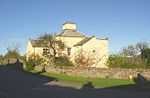
| Church of St Bega |
Bassenthwaite |
Church |
1150 !12th century |
01967-03-03-00003 March 1967 |
NY2266228748
54°38′52″N 3°12′00″W / 54.647882°N 3.200038°W / 54.647882; -3.200038 (Church of St Bega) |
1332957 |
More images
|
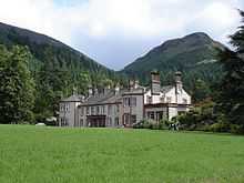
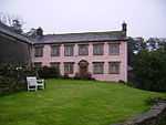
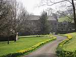
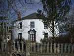
| Mirehouse |
Bassenthwaite |
House |
1690 !Late 17th century |
01967-03-03-00003 March 1967 |
NY2317828378
54°38′41″N 3°11′31″W / 54.644637°N 3.191946°W / 54.644637; -3.191946 (Mirehouse) |
1326263 |
|
| Table tomb south of chancel of Church of St Michael |
Isel, Blindcrake |
Table tomb |
1490 !Late 15th century |
01986-09-05-00005 September 1986 |
NY1625433303
54°41′16″N 3°18′02″W / 54.687782°N 3.300624°W / 54.687782; -3.300624 (Table tomb south of chancel of Church of St Michael) |
1312018 |

|
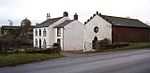
| Weary Hall |
Mealsgate, Boltons |
Farmhouse |
1550 !Mid-16th century |
01967-04-11-000011 April 1967 |
NY2178141836
54°45′55″N 3°13′02″W / 54.765336°N 3.217205°W / 54.765336; -3.217205 (Weary Hall) |
1137761 |
|
| Church of St Michael |
Bowness-on-Solway |
Church |
1150 !12th century |
01967-04-11-000011 April 1967 |
NY2237662646
54°57′09″N 3°12′49″W / 54.952393°N 3.213563°W / 54.952393; -3.213563 (Church of St Michael) |
1137007 |
More images
|
| Fingland Farmhouse and adjoining barn |
Fingland, Bowness |
Farmhouse |
1690 !Late 17th century |
01967-04-11-000011 April 1967 |
NY2547157119
54°54′12″N 3°09′50″W / 54.903209°N 3.163813°W / 54.903209; -3.163813 (Fingland Farmhouse and adjoining barn) |
1327125 |
|
| Parsonage Farmhouse |
Brigham |
Farmhouse |
1300 !13th or 14th century |
01967-03-03-00003 March 1967 |
NY0858430987
54°39′56″N 3°25′08″W / 54.66564°N 3.41884°W / 54.66564; -3.41884 (Parsonage Farmhouse) |
1145197 |
|
| Hesket Hall Farmhouse |
Hesket Newmarket, Caldbeck |
Farmhouse |
1675 !Mid- or late 17th century |
01967-04-11-000011 April 1967 |
NY3397338646
54°44′18″N 3°01′37″W / 54.738428°N 3.027028°W / 54.738428; -3.027028 (Hesket Hall Farmhouse) |
1144444 |
|
| Castlegate House |
Cockermouth |
Detached house |
1750 !Mid-18th century |
01951-08-28-000028 August 1951 |
NY1234430839
54°39′54″N 3°21′38″W / 54.664979°N 3.360519°W / 54.664979; -3.360519 (Castlegate House) |
1327097 |
|
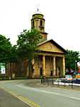
| Church of All Saints |
Cockermouth |
Church |
1854 !1852–54 |
01951-08-28-000028 August 1951 |
NY1236430640
54°39′47″N 3°21′37″W / 54.663194°N 3.360149°W / 54.663194; -3.360149 (Church of All Saints) |
1144744 |
More images
|
| Cobbled forecourt to Nos 45 and 47, Kirkgate |
Cockermouth |
House |
1790 !Late 18th century |
01951-08-28-000028 August 1951 |
NY1243830584
54°39′46″N 3°21′32″W / 54.662704°N 3.358985°W / 54.662704; -3.358985 (Cobbled forecourt to Nos 45 and 47, Kirkgate) |
1327064 |
|
| Norham House |
Cockermouth |
House |
1750 !18th century |
01969-12-18-000018 December 1969 |
NY1193830671
54°39′48″N 3°22′00″W / 54.663398°N 3.366761°W / 54.663398; -3.366761 (Norham House) |
1144717 |
|
| 6 Castlegate |
Cockermouth |
House |
1790 !Late 18th century |
01951-08-28-000028 August 1951 |
NY1231330789
54°39′52″N 3°21′40″W / 54.664524°N 3.360984°W / 54.664524; -3.360984 (6 Castlegate) |
1327096 |
|
| 5, 7 Castlegate |
Cockermouth |
House |
1750 !Mid-18th century |
01951-08-28-000028 August 1951 |
NY1228930787
54°39′52″N 3°21′41″W / 54.664502°N 3.361356°W / 54.664502; -3.361356 (5, 7 Castlegate) |
1373837 |
|
| 38, 40 and 42 Market Place |
Cockermouth |
Cross passage house |
1525 !Early–mid-16th century |
01974-07-26-000026 July 1974 |
NY1225930745
54°39′51″N 3°21′43″W / 54.664119°N 3.361808°W / 54.664119; -3.361808 (38, 40 and 42 Market Place) |
1327092 |
|
| Crakeplace Hall |
Ullock, Dean |
Farmhouse |
1550 !Mid-16th century |
01967-03-03-00003 March 1967 |
NY0700424032
54°36′10″N 3°26′28″W / 54.602868°N 3.441116°W / 54.602868; -3.441116 (Crakeplace Hall) |
1326884 |
|
| Church of St Mary |
Gilcrux |
Church |
1836 |
01967-03-03-00003 March 1967 |
NY1173438176
54°43′51″N 3°22′20″W / 54.730788°N 3.372197°W / 54.730788; -3.372197 (Church of St Mary) |
1275717 |
More images
|
| Mill Grove |
Abbeytown, Holme Abbey |
Former infirmary |
1472 !Before 1472 |
01967-04-01-00001 April 1967 |
NY1774650693
54°50′39″N 3°16′57″W / 54.844264°N 3.282419°W / 54.844264; -3.282419 (Mill Grove) |
1212550 |
|
| Aisle columns west of Ireby Old Church |
Ireby |
Gate pier |
1250 !13th century |
01986-01-03-00003 January 1986 |
NY2237239311
54°44′34″N 3°12′26″W / 54.742742°N 3.207347°W / 54.742742; -3.207347 (Aisle columns west of Ireby Old Church) |
1146404 |
|
| Orthwaite Hall and adjoining barn |
Orthwaite, Ireby and Uldale |
Farmhouse |
1600 !Late 16th or early 17th century |
01967-04-11-000011 April 1967 |
NY2527234183
54°41′50″N 3°09′40″W / 54.697109°N 3.160993°W / 54.697109; -3.160993 (Orthwaite Hall and adjoining barn) |
1144419 |
|
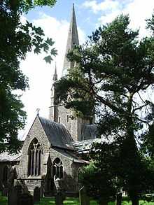
| Church of St John |
Keswick |
Church |
1838 |
01951-10-02-00002 October 1951 |
NY2678823181
54°35′55″N 3°08′05″W / 54.59848°N 3.134718°W / 54.59848; -3.134718 (Church of St John) |
1144666 |
More images
|
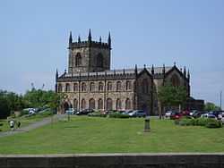
| Church of St Kentigern |
Great Crosthwaite, Keswick |
Church |
1350 !14th century |
01951-10-02-00002 October 1951 |
NY2574124285
54°36′30″N 3°09′04″W / 54.608246°N 3.1512°W / 54.608246; -3.1512 (Church of St Kentigern) |
1327118 |
More images
|
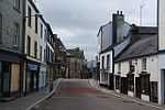
| The Moot Hall |
Keswick |
Moot hall |
1571 |
01951-10-02-00002 October 1951 |
NY2663223436
54°36′03″N 3°08′14″W / 54.600748°N 3.137196°W / 54.600748; -3.137196 (The Moot Hall) |
1137345 |
More images
|
| Church of St Bride |
Kirkbride |
Church |
1150 !12th century |
01967-04-01-00001 April 1967 |
NY2296057329
54°54′17″N 3°12′11″W / 54.904715°N 3.203019°W / 54.904715; -3.203019 (Church of St Bride) |
1144617 |
|
| Lilac House |
Kirkbride |
House |
1650 !17th century |
02011-01-06-00006 January 2011 |
NY2293656944
54°54′05″N 3°12′12″W / 54.901252°N 3.20329°W / 54.901252; -3.20329 (Lilac House) |
1396397 |
|
| Allanby House |
Flimby, Maryport |
House |
1731 |
01950-07-29-000029 July 1950 |
NY0239433468
54°41′12″N 3°30′56″W / 54.686766°N 3.515604°W / 54.686766; -3.515604 (Allanby House) |
1137677 |
|
| Flimby Hall |
Flimby, Maryport |
House |
1766 |
01950-07-29-000029 July 1950 |
NY0239633503
54°41′13″N 3°30′56″W / 54.687081°N 3.515585°W / 54.687081; -3.515585 (Flimby Hall) |
1137687 |
|
| Netherhall |
Maryport |
Country house |
1780 !Mid- and late Georgian |
01950-07-29-000029 July 1950 |
NY0432536908
54°43′05″N 3°29′12″W / 54.71804°N 3.486792°W / 54.71804; -3.486792 (Netherhall) |
1137621 |
|
| Dovecote south of Church of St Cuthbert |
Parsonby, Plumbland |
Dovecote |
1550 !16th century |
01985-08-13-000013 August 1985 |
NY1417939159
54°44′24″N 3°20′04″W / 54.740043°N 3.33453°W / 54.740043; -3.33453 (Dovecote south of Church of St Cuthbert) |
1217363 |
|
| Church of St Mary |
Churchtown, Sebergham |
Church |
Medieval |
01967-04-11-000011 April 1967 |
NY3640841853
54°46′03″N 2°59′24″W / 54.767558°N 2.989918°W / 54.767558; -2.989918 (Church of St Mary) |
1327246 |
|
| Sebergham Hall |
Sebergham |
House |
1690 !Late 17th century |
01986-01-03-00003 January 1986 |
NY3636642442
54°46′22″N 2°59′27″W / 54.772844°N 2.9907°W / 54.772844; -2.9907 (Sebergham Hall) |
1144392 |
|
| Warnell Hall |
Sebergham |
Farmhouse |
1525 !Early or mid-16th century |
01967-04-11-000011 April 1967 |
NY3505241339
54°45′46″N 3°00′39″W / 54.762765°N 3.010875°W / 54.762765; -3.010875 (Warnell Hall) |
1311727 |
|
| Courtyard range and gatehouse with barn adjoining, Warnell Hall |
Sebergham |
Courtyard |
1510 !Early 16th century |
01986-01-03-00003 January 1986 |
NY3506741323
54°45′45″N 3°00′38″W / 54.762624°N 3.010638°W / 54.762624; -3.010638 (Courtyard range and gatehouse with barn adjoining, Warnell Hall) |
1144400 |
|
| Hewthwaite Hall |
Setmurthy |
Farmhouse |
1581 |
01967-03-03-00003 March 1967 |
NY1523832836
54°41′00″N 3°18′58″W / 54.683416°N 3.316245°W / 54.683416; -3.316245 (Hewthwaite Hall) |
1145129 |
|
| Millbeck Hall and adjoining barn |
Millbeck, Underskiddaw |
Farmhouse |
1592 |
01967-03-03-00003 March 1967 |
NY2559526082
54°37′28″N 3°09′14″W / 54.624371°N 3.153917°W / 54.624371; -3.153917 (Millbeck Hall and adjoining barn) |
1121974 |
|
| Fiddleback |
West Woodside, Westward |
Farmhouse |
1709 |
01967-04-11-000011 April 1967 |
NY3073049170
54°49′57″N 3°04′48″W / 54.832547°N 3.079905°W / 54.832547; -3.079905 (Fiddleback) |
1311657 |
|
| Islekirk Hall |
Westward |
House |
1550 !Mid-16th century |
01967-04-11-000011 April 1967 |
NY2594344526
54°47′24″N 3°09′12″W / 54.790137°N 3.153222°W / 54.790137; -3.153222 (Islekirk Hall) |
1274096 |
|
| Jenkin's Cross |
Westward |
Farmhouse |
1810 !Early 19th century |
01967-04-11-000011 April 1967 |
NY2894447915
54°49′16″N 3°06′27″W / 54.821021°N 3.107394°W / 54.821021; -3.107394 (Jenkin's Cross) |
1238648 |
|
| Meadow Bank Farmhouse |
West Curthwaite, Westward |
Farmhouse |
1666 |
01967-04-11-000011 April 1967 |
NY3238548926
54°49′50″N 3°03′15″W / 54.830582°N 3.054088°W / 54.830582; -3.054088 (Meadow Bank Farmhouse) |
1144410 |
|
| Church of St Mary |
Wigton |
Church |
1788 |
01967-04-01-00001 April 1967 |
NY2559948273
54°49′26″N 3°09′34″W / 54.823751°N 3.159534°W / 54.823751; -3.159534 (Church of St Mary) |
1144590 |
More images
|
| Byres to north of Schoose Farm House |
Schoose, Workington |
Cow house |
1810 !Early 19th century |
01985-12-13-000013 December 1985 |
NY0146028044
54°38′16″N 3°31′42″W / 54.637857°N 3.528256°W / 54.637857; -3.528256 (Byres to north of Schoose Farm House) |
1138196 |
|
| Church of St John and adjoining community hall |
Workington |
Church |
1823 !1822–23 |
01951-06-06-00006 June 1951 |
NY0043228499
54°38′30″N 3°32′40″W / 54.641743°N 3.544332°W / 54.641743; -3.544332 (Church of St John and adjoining community hall) |
1138257 |
|
| Church of St Michael |
Workington |
Church |
1150 !12th century |
01951-06-06-00006 June 1951 |
NX9973428956
54°38′45″N 3°33′19″W / 54.64571°N 3.5553°W / 54.64571; -3.5553 (Church of St Michael) |
1144492 |
More images
|
| Granary east of Schoose Farmhouse |
Schoose, Workington |
Granary |
1800 !c. 1800 |
01985-12-13-000013 December 1985 |
NY0150228002
54°38′15″N 3°31′39″W / 54.637488°N 3.527592°W / 54.637488; -3.527592 (Granary east of Schoose Farmhouse) |
1144490 |
|
| Helena Thompson Museum and former stables |
Workington |
House |
1790 !Late 18th century |
01951-06-06-00006 June 1951 |
NY0087828563
54°38′33″N 3°32′15″W / 54.642406°N 3.537446°W / 54.642406; -3.537446 (Helena Thompson Museum and former stables) |
1311987 |
|
| Schoose Farmhouse and adjoining barns |
Schoose, Workington |
Farmhouse |
1800 !c. 1800 |
01985-12-13-000013 December 1985 |
NY0142828018
54°38′15″N 3°31′43″W / 54.637618°N 3.528743°W / 54.637618; -3.528743 (Schoose Farmhouse and adjoining barns) |
1144489 |
|
| St Michael's House |
Workington |
House |
1450 !15th century |
01985-12-13-000013 December 1985 |
NX9980728963
54°38′45″N 3°33′15″W / 54.645787°N 3.554172°W / 54.645787; -3.554172 (St Michael's House) |
1144478 |
|
| Windmill, adjoining barns, gatehouse and curtain wall |
Schoose, Workington |
Farm buildings |
1800 !c. 1800 |
01985-12-13-000013 December 1985 |
NY0140427985
54°38′14″N 3°31′45″W / 54.637317°N 3.529104°W / 54.637317; -3.529104 (Windmill, adjoining barns, gatehouse and curtain wall) |
1327213 |
|