Gradačac
| Gradačac | ||
|---|---|---|
| Municipality and town | ||
.JPG) | ||
| ||
 Location of Gradačac within Bosnia and Herzegovina. | ||
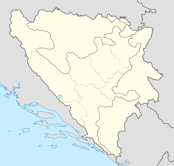 Gradačac Location of Gradačac | ||
| Coordinates: 44°53′N 18°26′E / 44.883°N 18.433°E | ||
| Country |
| |
| Government | ||
| • Municipality president | Edis Dervišagić (SDP) | |
| Area | ||
| • Total | 218 km2 (84 sq mi) | |
| Population (2013 census) | ||
| • Total | 41,836 | |
| • Density | 192/km2 (500/sq mi) | |
| Time zone | CET (UTC+1) | |
| • Summer (DST) | CEST (UTC+2) | |
| Area code(s) | +387 35 | |
| Website | gradacac.ba/ | |

Gradačac (Bosnian pronunciation: [gradǎt͡ʃat͡s]) is a town and municipality in the northeastern part of Bosnia and Herzegovina, located roughly 40 km (25 mi) south of the Sava river. Administratively, Gradačac is part of the Tuzla Canton of the Federation of Bosnia and Herzegovina. The towns of Bosanski Šamac and Modriča lie near Gradačac.
Settlements
• Avramovina • Biberovo Polje • Blaževac • Cetnica • Donja Međiđa • Donja Tramošnica • Donje Krečane • Donje Ledenice • Donji Lukavac • Donji Skugrić • Gornja Međiđa • Gornja Tramošnica • Gornje Krečane • Gornje Ledenice • Gornji Lukavac • Gradačac • Hrgovi Donji • Jasenica • Jelovče Selo • Kerep • Krčevljani • Mionica • Njivak • Orlovo Polje • Škorići • Pelagićevo • Porebrice • Rajska • Samarevac • Sibovac • Srnice Donje • Srnice Gornje • Tolisa • Turić • Vida • Vučkovci • Zelinja Donja • Zelinja Gornja i Zelinja Srednja.
Demographics
1971
48,384 total
- Bosniaks – 26,905 (55.60%)
- Serbs – 12,455 (25.74%)
- Croats – 8,447 (17.45%)
- Yugoslavs – 321 (0.66%)
- others – 256 (0.55%)
1991
In the census of 1991, the municipality of Gradačac had 56,378 residents of which there were:
- 60.2% Bosniaks
- 19.8% Serbs
- 15.1% Croats
- 4.9% others
History
The župa of Gradačac was first mentioned in 1302, while the town's first written mention dates from 1465 (also as Gračac). The town became part of the Ottoman Empire in 1512, its nahija (municipality) was first recorded in the defter of 1533, while its kadiluk (county) was recorded in 1634.
In 1701 the settlement was given the status of a palanka (city), and it became the headquarters of a military captaincy in 1710. The captains of the Gradaščević family led the development of the city, and the most famous of them, Husein-kapetan Gradaščević or Zmaj od Bosne ("Dragon of Bosnia"), led an uprising that raised to arms most of the Bosnian captains in 1831.
The town has a fort with 18-meter high walls built between 1765 and 1821, and a 22-meter high watchtower, built in 1824 by Husein-kapetan Gradaščević on foundations made originally by the Romans. Husejnija Mosque was built in 1826.
From 1929 to 1929, Gradačac was part of the Vrbas Banovina and from 1939 to 1941 of the Banovina of Croatia within the Kingdom of Yugoslavia.
It was severely bombed during the Bosnian war 1992–1995. It is located at the narrow northern corridor that connects two major portions of the Bosnian Serb entity Republika Srpska, near Brčko. Gradačac became part of the Tuzla Canton in the Federation of Bosnia and Herzegovina after the war.
Thermal springs
The first spa facility, Ilidža Spa Treatment Centre was built on the thermal springs in Gradačac in 1882. The water temperature is 29.30˚C. In the area nearby are also two lakes Hazna and Vidara.
Economy
The most important industries in Gradačac are textile, chemical, mechanical and food processing. Gradačac is the place where the traditional international fair for plums is held.
Education
In the municipality there are 2 high schools, 7 elementary and 14 regional schools.
Sport
Notable people
- Stevan Dedijer, academic
- Husein Gradaščević, nobleman
- Ahmed Muradbegović, writer
- Mustafa Imamović, historian
- Mina Imširović, author
International relations
Twin towns and sister cities
Gradačac is twinned with:
Picture gallery
-
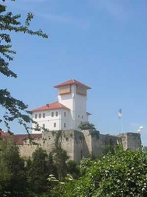
Castle of Gradačac
-
.JPG)
Hazna Lake
-

Birth house of Captain Husein Gradaščević
-
.JPG)
Old Clock Tower
See also
References
- ↑ Uzaklar Yakinlaşti - Sivas Twin Towns(Turkish)
External links
| ||||||||
Coordinates: 44°53′N 18°26′E / 44.883°N 18.433°E
| Wikimedia Commons has media related to Gradačac. |