Government Center (MBTA station)
GOVERNMENT CENTER
GOVERNMENT CENTER | ||||||||||||||||||||||||||||||
|---|---|---|---|---|---|---|---|---|---|---|---|---|---|---|---|---|---|---|---|---|---|---|---|---|---|---|---|---|---|---|
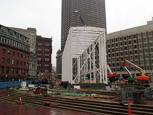 Construction of Government Center station in November 2014 | ||||||||||||||||||||||||||||||
| Location | Near Boston City Hall at intersection of Tremont, Court and Cambridge Streets, Downtown Boston | |||||||||||||||||||||||||||||
| Coordinates | 42°21′34″N 71°03′34″W / 42.35944°N 71.05944°WCoordinates: 42°21′34″N 71°03′34″W / 42.35944°N 71.05944°W | |||||||||||||||||||||||||||||
| Owned by | MBTA | |||||||||||||||||||||||||||||
| Line(s) | ||||||||||||||||||||||||||||||
| Platforms |
1 island platform (Blue Line) 1 triangular island platform (Green Line) | |||||||||||||||||||||||||||||
| Tracks |
Blue Line: 2 Green Line: 2 plus non-revenue loop track | |||||||||||||||||||||||||||||
| History | ||||||||||||||||||||||||||||||
| Opened |
September 3, 1898 (Green Line) March 18, 1916 (Blue Line) | |||||||||||||||||||||||||||||
| Closed | March 22, 2014 (temporarily) | |||||||||||||||||||||||||||||
| Rebuilt | 2014–2016 | |||||||||||||||||||||||||||||
| Previous names | Scollay (1898–1969) | |||||||||||||||||||||||||||||
| Traffic | ||||||||||||||||||||||||||||||
| Passengers (2013) | 10,828 (weekday average boardings)[1] | |||||||||||||||||||||||||||||
| Services | ||||||||||||||||||||||||||||||
| ||||||||||||||||||||||||||||||
Government Center is a temporarily closed MBTA subway station and a transfer point between the Green Line and the Blue Line. It is located at the intersection of Tremont, Court and Cambridge Streets in the Government Center area of Boston. The Green Line platform opened in 1898, and holds the distinction of being the third oldest operating subway station in the MBTA system after Park Street and Boylston. The station is closed from 2014 to 2016 for a major renovation, which includes retrofitting the station for handicapped accessibility and building a new glass headhouse on City Hall Plaza. The current renovation project will make the station fully accessible when it re-opens in 2016.[2]
History
Early history

Before Boston City Hall Plaza was built at its current location, completely replacing old Scollay Square, the underground station platforms were known as Scollay on what would become the Green Line, and Scollay Under on what would be called the Blue Line. An original tile mosaic "Scollay" sign has remained visible on the rarely used inbound loopback track at the upper (Green Line) level.
Years later, when the false walls at both ends of the lower (Blue Line) platform were removed to accommodate the change from four- to six-car trains, several surviving original tile mosaic "Scollay Under" signs were uncovered.
The 1963-built headhouse was often described as resembling a bunker or a cave, even by MBTA management.[3]
Renovation
Beginning March 22, 2014, Government Center Station was closed for approximately two years while crews work to upgrade the station into a fully accessible, safer, modern, more comfortable facility. The current schedule is:
- Construction Contract Award (NTP): July 2013
- Prepare station for closure (electrical, structural, civil engineering): Second Quarter through Fourth Quarter 2013
- Reconfigure roadways and sidewalks for station closure: Fourth Quarter 2013 to Second Quarter 2014. This work was to begin the week of November 18, 2013.
- Close station for reconstruction: Second Quarter 2014
- Reopen station: Second Quarter 2016
- Completion of construction: Fourth Quarter 2016
Improvements will make Government Center Station wheelchair accessible for the first time, and will include new elevators, a new station entrance and lobbies, a new emergency exit-only structure on Cambridge Street between Court and Sudbury Street, new escalators, new LED signage, new and expanded fare collection area, upgraded back-up electrical power supply, improved interior finishes, and new station lighting, mechanical systems, and public address system. Additional vendor retail space will also be provided on both Green Line and Blue Line platforms.
During Government Center station's closure, Green Line trains can pass through, but will not stop there. The last downtown stop will generally be the following for each branch:
- B Line (Boston College) will end at Park Street
- C Line (Cleveland Circle) will end at North Station as usual
- D Line (Riverside) will end at Park Street during rush hours, and North Station at other times
- E Line will end at Lechmere as usual
While the station is being rebuilt, the recommended path of travel for Green Line customers connecting to the Blue Line is to ride to Haymarket Station and transfer to the Orange Line toward Forest Hills (southbound). Customers should then exit the Orange Line at State Street Station for Blue Line connections. The recommended path of travel for Blue Line customers connecting to the Green Line is to get off at State Street and transfer to the Orange Line toward Oak Grove (northbound). Customers should then exit at Haymarket Station for Green Line connections. Additionally, Bowdoin Station will be open during all hours of subway service, for the duration of Government Center's closure. A shuttle bus will also operate, leaving Haymarket Station busway every twenty minutes from 5:20 a.m. to 12:20 a.m. seven days a week (Sundays, the shuttle begins at 6:00 a.m.). The bus will make stops outside State Street Station, Government Center Station, Bowdoin Station, and then return to Haymarket. [4]
During the first two months of renovations, two additional Scollay Under tile signs were uncovered on the Blue Line level.[5] After the first sign was discovered in April, the MBTA announced that it would be restored and placed in the renovated station, similar to previously found mosaics at South Station and Arlington.[6] In total, three Scollay Under and two single-letter mosaics will be restored. An original faregate and ticket booth have also been found.[7]
By September 2014, demolition was complete and the steel frame of the new glass headhouse had been erected. At that point, the project was on schedule and on budget.[7]
Green Line congestion and Red-Blue Connector
The Red and Blue Lines are the only pair of rapid transit lines in the MBTA system that lack a direct transfer connection. Before the Government Center station was closed for reconstruction, the Green Line was the most convenient way to transfer between the Blue Line and the Red Line, thus causing the short Green Line segment between Government Center station and nearby Park Street station to be especially congested during peak travel times. This bottleneck, combined with tight platform clearances on the Green Line outbound side at Government Center, has been the cause of significant delays and crowding on the Green Line. In the past, an underground pedestrian passage had been proposed, paralleling the Green Line tracks and connecting the two stations (similar to the Winter Street Concourse between Park Street and Downtown Crossing), but this idea was dropped in favor of a direct transfer connection between the Blue and Red Lines. There are no active plans to build it, however, and the Green Line connection will presumably resume its role once Government Center station reopens.
It also is possible to transfer between the Red and Blue Lines by traveling one stop on the Orange Line between State and Downtown Crossing stations, but this path involves navigating a longer and more convoluted path through stairs and passages of those stations; for the duration of Government Center's closure, however, it is the only possible way to transfer between the two using the MBTA's subway system.
In popular culture
Government Center station was featured in the video game Tony Hawk's Underground 2 in the Boston level.
References
- ↑ "Ridership and Service Statistics" (PDF) (14 ed.). Massachusetts Bay Transportation Authority. 2014. Retrieved 30 July 2014.
- ↑ Powers, Martine (22 March 2014). "Government Center closing for 2 years for upgrades". Boston Globe. Retrieved 20 May 2014.
- ↑ Weir, Richard (4 October 2010). "Redesign fits Government Center to a T". Boston Herald. Retrieved 3 August 2014.
- ↑ http://www.mbta.com/riding_the_t/default.asp?id=26899
- ↑ Powers, Martine (7 May 2014). "Second ‘Scollay Under’ sign found at Government Center". Boston Globe. Retrieved 9 May 2014.
- ↑ Powers, Martine (7 April 2014). "‘Scollay Under’ sign uncovered at Government Center station". Boston Globe. Archived from the original on 8 April 2014. Retrieved 9 May 2014.
- ↑ 7.0 7.1 Crimaldi, Laura (21 September 2014). "Government Center T station to feature glass entryway". Boston Globe. Retrieved 22 September 2014.
Further reading
- Belcher, Jonathan, "Remnants of Abandoned Stations, Tunnels, and Station Entrances found on the MBTA" (archived 2007)
- Bierman, Noah, "Transit archeology: Tour of abandoned subway network offers a glimpse of how the T was built", Boston Globe, Saturday, December 26, 2009.
- Cheape, Charles W. (1980). Moving the masses : urban public transport in New York, Boston and Philadelphia, 1880–1912. Cambridge, Mass.: Harvard University Press. ISBN 0-674-58827-4.
- Cheney, Frank; Sammarco, Anthony Mitchell (2000). When Boston rode the El. Charleston, SC: Arcadia. ISBN 978-0-7385-0462-9.
- Cudahy, Brian J. (1972). Change at Park Street Under; the story of Boston's subways. Brattleboro, Vt.: S. Greene Press. ISBN 978-0-8289-0173-4.
- McKendry, Joe (2006). Beneath the streets of Boston: Building America's first subway. Boston: David R. Godine. ISBN 978-1-56792-284-4.
External links
| Wikimedia Commons has media related to Government Center (MBTA station). |
- MBTA - Government Center
- Government Center Project page
- Former Court Street entrance from Google Maps Street View
| ||||||||||||||||||||||||||||||||||||||||||||||||||||||||||