Gorontalo
| Gorontalo Province Provinsi Gorontalo | |||
|---|---|---|---|
| Province | |||
| Province of Gorontalo | |||
| |||
|
Motto: Duluo Limo Lo Pohalaa (Gorontalo) (The land of Medina's gate) | |||
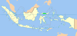 Location of Province of Gorontalo in Indonesia | |||
| Coordinates: 0°40′N 123°00′E / 0.667°N 123.000°ECoordinates: 0°40′N 123°00′E / 0.667°N 123.000°E | |||
| Country | Indonesia | ||
| Capital | Gorontalo | ||
| Government | |||
| • Governor | Rusli Habibie (Golkar) | ||
| • Vice Governor | Idris Rahim | ||
| Area | |||
| • Total | 11,257.07 km2 (4,346.38 sq mi) | ||
| Population (2014)[1] | |||
| • Total | 1,134,498 | ||
| • Density | 100/km2 (260/sq mi) | ||
| Demographics | |||
| • Ethnic groups | Gorontaloan, Mongondowi, Atinggolan, Bolangoan, Suwawan | ||
| • Religion | Islam (97.81%), Protestantism (1.59%), Hinduism (0.35%), Buddhism (0.09%) | ||
| • Languages | Indonesian (official), Gorontalo | ||
| Time zone | CIT (UTC+08) | ||
| Website | gorontaloprov.go.id | ||

Gorontalo (Indonesian: Gorontalo) is a province of Indonesia. It is located in the north of the island of Sulawesi on the Minahassa Peninsula. The province's population was 1,040,164 at the 2010 census, and the latest estimate (for January 2014) is 1,134,498; its capital is the city of Gorontalo.
The province was established in December 2000 being split off from the province of North Sulawesi.[2]
Etymology
There are several hypothesis about the etymology of the name Gorontalo.:[3]
- from Hulontalangio, the name of a tribe that resided in the area
- from Hua Lolontalango, which means cavemen who used to walk back and forth
- from Hulutalangi, which means nobler
- from Huluo Lo Tola, which means a place where snakehead fish breed
- from Pongolatalo or Pohulatalo, which means: a waiting place
- from Gunung Telu, which means three mountains
- from Hunto, which means a place that is always flowed by water
Geography
Gorontalo lies on the northern Sulawesi arm, known as the Gorontalo Peninsula. The province has an elongated shape area, stretching from west to east almost horizontally on a map, with total area of 11,257.07 km2 (4,346.38 sq mi).[4] To the north and the south of the province are the Sulawesi Sea and the Gulf of Gorontalo or known as Gulf of Tomini, respectively. Prior to 2000, Gorontalo province was part of North Sulawesi province which lies on the eastern border.[2] The western border of the province is Central Sulawesi province.
Topography of the province is relatively low (0—40o), with the elevation ranging between 0—2,400 m (7,900 ft) above sea level. Its coastline length is more than 590 km (370 mi). Counting the Exclusive Economic Zone to the north where Philippines is at the border, the total sea area of the province is more than 50,500 km2 (19,500 sq mi).[4] There are some small islands around the north and the south of the province, 67 of which have been identified and named.[4]
Its population has grown from 833,500 in the 2000 census to about 1,040,000 at the 2010 census,[5] with nearly half the population residing in Gorontalo Regency or Gorontalo City.
History
In 1525, with Portuguese assistance, three small rock forts were built overlooking the waters of Lake Limboto. Still in place today, the Fort Otonaha complex has commanding views. The Spanish also entered the area in limited numbers via the Philippines during the mid-16th century. They introduced corn, tomatoes, chili peppers, horses, and the afternoon siesta to Gorontalo, all of which are an integral part of life there today. The Dutch under the aegis of the Dutch East India Company (VOC) worked to wrest control of the lucrative spice trade away from the Sultanate of Ternate and push out all other European competitors. Gradually, the Dutch gained political control and ended the power of the local kings.
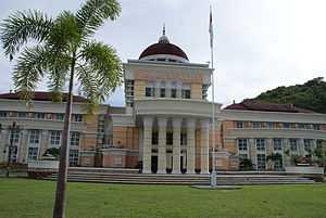
The people of Gorontalo achieved independence from Dutch rule in 1942. This was partly through the efforts of the guerrilla/freedom fighter and local hero Nani Wartabone, who forced out the occupying Japanese during World War II. Since the city escaped Allied bombing during the war, a number of Dutch-era buildings are still standing. Although many are in poor condition, Gorontalo City has a distinctive colonial appearance.
After Indonesia proclaimed its independence, Gorontalo became part of North Sulawesi province, but was split away from North Sulawesi in 2000.
Administrative divisions
The governor and vice-governor, who are elected directly by the people, head the provincial administration. The province is divided into five regencies (Indonesian: kabupaten) and only one city (Indonesian: kota). When the province was established in 2000, there were only two regencies and the city in the province. Splitting of regencies occurred in 2003 (when Pohuwato Regency was created from the western part of Boalemo Regency, and Bone Bolango Regency was created from the eastern part of Gorontalo Regency) and 2007 (when North Gorontalo Regency was created from the northern part of Gorontalo Regency).
As of 2010, the list of regencies and cities in Gorontalo province is given in the table below.
| Name | Capital | Est. | Established by Statute | Area (km²) | Population Census 2010 | Population Estimate 2014 |
|---|---|---|---|---|---|---|
| Gorontalo City | * | 1959 | UU 29/1959 | 79.59 | 180,127 | 196,464 |
| Boalemo Regency | Tilamuta | 1999 | UU 50/1999 | 1,521.88 | 129,253 | 140,975 |
| Bone Bolango Regency | Suwawa | 2003 | UU 6/2003 | 1,984.31 | 141,915 | 154,785 |
| Gorontalo Regency | Limboto | 1959 | UU 29/1959 | 1,750.83 | 355,988 | 388,273 |
| North Gorontalo Regency (Gorontalo Utara) | Kwandang | 2007 | UU 11/2007 | 1,676.15 | 104,133 | 113,577 |
| Pohuwato Regency | Marisa | 2003 | UU 6/2003 | 4,244.31 | 128,748 | 140,424 |
Note: * A city and also the provincial capital.
| Historical population | ||
|---|---|---|
| Year | Pop. | ±% |
| 2000 | 835,044 | — |
| 2010 | 1,040,164 | +24.6% |
| Source: Statistics Indonesia 2010 | ||
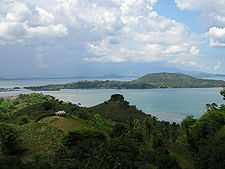
Tourism
Tourist sites in the province include:[6]
- Taruna Remaja Square (Old Town)
- The 2,000 Stairs
- Museum of Sukarno's Landing at Lake Limboto
- Bubohu Bongo religious excursion village
- Maleo bird sanctuary and Nani Wartabone National Park
Sumalata Waters Reserve
The islands of Pepaya, Mas and Raja islands, located in the Sumalata Waters in North Gorontalo, have been named a nature reserve since the Dutch colonial time in 1936. Four of the only seven species of turtles can be found in the islands, the world's best turtle habitat. They include Penyu Hijau (Chelonia midas), Penyu Sisik (Eretmochelys imbricata), Penyu Tempayan (Caretta caretta) and Penyu Belimbing (Dermochelys coriacea). In 2011, the habitat was threatened by human activities such as illegal poaching and fish bombing activities; furthermore a lot of coral reefs, which represent a source of food for turtles, have been damaged.[7]
References
- ↑ "Gorontalo Profile" (Press release). Statistics Indonesia. Retrieved 2007-08-27.
- ↑ 2.0 2.1 Government of Indonesia (22 December 2000). "Establishment of Gorontalo Province" (PDF) (in Indonesian ed.). Indonesia Ministry of Law and Justice - www.legalitas.org. UU No. 38/2000. Retrieved 2007-08-27.
- ↑ "The History of Province of Gorontalo". Sejarah Provinsi Gorontalo (in Indonesian). Statistics Bureau of Province of Gorontalo. Retrieved 2008-10-10.
- ↑ 4.0 4.1 4.2 "Geographical Condition". Gorontalo ~ Provinsi Agropolitan (in Indonesian). Provincial Government of Gorontal. Archived from the original on 2007-07-16. Retrieved 2007-08-27.
- ↑ http://gorontalo.bps.go.id/
- ↑ Syamsul Huda M. Suhari, 'Five Leisure spots in Gorontalo', The Jakarta Post, 28 February 2014.
- ↑ http://www.antaranews.com/en/news/72396/worlds-best-turtle-habitat-in-gorontalo-threatened
| ||||||||||||||||||||||||||||||