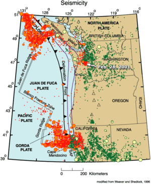
Gorda Plate

The Gorda Plate, located beneath the Pacific Ocean off the coast of northern California, is one of the northern remnants of the Farallon Plate. It is sometimes referred to (by, for example, publications from the USGS Earthquake Hazards Program)[1] as simply the southernmost portion of the neighboring Juan de Fuca Plate, another Farallon remnant.
Unlike most tectonic plates, the Gorda Plate experiences significant deformation inside its boundaries. Numerous faults have been mapped in both the sediments and basement of the Gorda Basin, which is in the interior of the plate south of 41.6°N.[2] Stresses from the neighboring North American Plate and Pacific Plate cause frequent earthquakes in the interior of the plate, including the M7.2 Humboldt County earthquake which caused $1.75 million in damages in 1980.[3]
The easterly side is a convergent boundary subducting under the North American Plate in northern California. The southerly side is a transform boundary with the Pacific Plate along the Mendocino Fault. The westerly side is a divergent boundary with the Pacific Plate forming the Gorda Ridge. The northerly side is a transform boundary with the Juan de Fuca Plate, the Blanco Fracture Zone.
The subducting Gorda Plate is connected with the volcanoes in northern California, namely, Mount Shasta and Lassen Peak. Lassen Peak last erupted in 1914–1917.
See also
References
- ↑ "National Earthquake Information Center (NEIC)". usgs.gov. Retrieved 12 December 2014.
- ↑ Gulick, S., Meltzer, A., and S. Clarke (1998) Seismic structure of the southern Cascadia subduction zone and accretionary prism north of the Mendocino triple junction. Journal of Geophysical Research-Solid Earth, 103(B11).
- ↑ "Historic Earthquakes". usgs.gov. Retrieved 12 December 2014.
External links
- USGS Understanding plate motions
- Mendocino Triple Junction Offshore Northern California
- Recent North Coast Earthquakes
- Cascadia tectonic history with map
Coordinates: 41°12′N 126°24′W / 41.2°N 126.4°W
| |||||||||||||||||||||||||
