Gopalapatnam
| Gopalapatnam గొపాలపట్నం | |
|---|---|
| Neighbourhood | |
|
Gopalapatnam Main Road | |
 Gopalapatnam Location in Andhra Pradesh, India | |
| Coordinates: 17°44′33″N 83°19′1″E / 17.74250°N 83.31694°ECoordinates: 17°44′33″N 83°19′1″E / 17.74250°N 83.31694°E | |
| Country |
|
| State | Andhra Pradesh |
| District | Visakhapatnam |
| Government | |
| • Body | Greater Visakhapatnam Municipal Corporation |
| Languages | |
| • Official | Telugu |
| Time zone | IST (UTC+5:30) |
| PIN | 530027 |
Gopalapatnam is at the Western side of the city of Visakhapatnam.
History
In 1942, Sri Gopala Raju - a wealthy man used to live in the area whose name was put for the area. He used to rule Kota gutta, Enugula Dwaram, Gurrala Cheruvu, Taati Penda areas which were united to form the present Gopalapatnam.
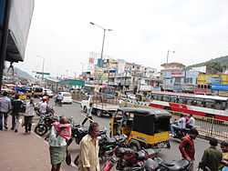
Commercial area
Gopalapatnam is a big business center. One can find almost all kinds of shops - from oil merchants to department stores, from clothing to ready mades, from televisions to electrical spares, from electrical repairs to hospitals, schools, etc. Gopalapatnam is the centre for shopping for many suburbs and villages. There is a vegetable market, Rythu bazaar here, making a good addition for vegetable shopping.
There are some popular restaurants serving Visakhapatnam food like Red cherries Bakers etc. There are seven movie theatres, all are A/C theatres. There are many shopping malls on the main road like Safe Arcade, SR Shopping Mall, CMR Shopping Mall, and Kumar's etc.
Transport
Gopalapatnam has an APSRTC bus depot, making it a hub of many buses bound to all parts of the city.
.
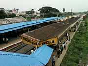
The closest Railway stations are at Simhachalam and North Simhachalam.
Schools
There are many schools here catering to all budgets.
References
| |||||||||||||||||||||||||||||