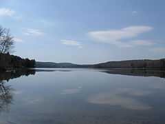
Goose Pond
| Goose Pond | |
|---|---|
 | |
| Location | Grafton County, New Hampshire |
| Coordinates | 43°42′9″N 72°5′38″W / 43.70250°N 72.09389°WCoordinates: 43°42′9″N 72°5′38″W / 43.70250°N 72.09389°W |
| Primary inflows |
Pressey Brook Marshall Brook |
| Primary outflows | Goose Pond Brook |
| Basin countries | United States |
| Max. length | 2.9 mi (4.7 km) |
| Max. width | 0.6 mi (0.97 km) |
| Surface area | 625 acres (2.5 km2) |
| Average depth | 10 ft (3.0 m) |
| Max. depth | 35 ft (11 m) |
| Surface elevation | 823 ft (251 m) |
| Settlements | Canaan; Hanover |
Goose Pond is a 625-acre (2.5 km2)[1] water body located in Grafton County in western New Hampshire, United States, in the towns of Canaan and Hanover. The lake is part of the Mascoma River watershed, flowing to the Connecticut River.
The lake is classified as a warmwater fishery, with observed species including smallmouth bass, largemouth bass, chain pickerel, horned pout, and white perch.[2] The state record smallmouth bass for New Hampshire was caught in this lake.
See also
References
- ↑ New Hampshire GRANIT state geographic information system
- ↑ "Goose Pond, Canaan, Hanover". NH Fish & Game. Retrieved August 15, 2014.