Gonbad-e Kavus
| Gonbad-e Kavus گنبد كاووس | |
|---|---|
| City | |
|
The tower is a remnant of Ziyarid architecture. | |
 Gonbad-e Kavus | |
| Coordinates: 37°15′00″N 55°10′02″E / 37.25000°N 55.16722°ECoordinates: 37°15′00″N 55°10′02″E / 37.25000°N 55.16722°E | |
| Country |
|
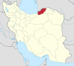
| Province | Golestān Province |
| County | Gonbad-e Kavus |
| Bakhsh | Central |
| Population (2011) | |
| • Total | 144,546[1] |
| Time zone | IRST (UTC+3:30) |
| • Summer (DST) | IRDT (UTC+4:30) |
| Gonbad-e Kavus at GEOnet Names Server | |
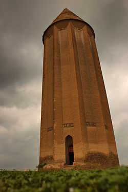
Gonbad-e Kāvus[2] (Persian: گنبد کاووس) is the city known historically as Gorgan/Hyrcania. The modern name, meaning "the tower of Kavus", is a reference to the most imposing ancient monument in the city. The historic name cannot now be restored, as it was oddly and carelessly assigned to the neighboring historical city of Astarabad in the 1930s by the Iranian Government. At one point, it was even known as the city of Dashte Gorgan,[3] meaning "the Plains of Gorgan".
This is a city in, and the capital of, Gonbad-e Kavus County, in the province of Golestān in the northeast of Iran. At the 2006 census, its population was 127,167, in 30,710 families.[4]
It is predominantly an ethnically Turkmen city, Turkmen being the spoken language,[5] but with substantial minority of Azeris and other smaller Iranian people.[6]
The city is famous for its historic brick tower of the same name.
Historical attractions
The "Divar-i Iskandar" (Persian for the "Wall of Alexander") or Qizil Alan (Turkmeni for "Red Snake") is a gigantic defensive wall built in the Sasanian period of Iranian history. The visible remains are about 155 km (96 mi) long and 6–10 m (20–33 ft) wide. It is one of the most outstanding and gigantic architectural monuments in northeast Iran and the most impressive in the Golestan Province. This wall, which is the largest defensive wall in the world after the Great Wall of China, starts from the Caspian sea coast, circles north of the city of Gonbad-e Kāvus, continues towards the northeast, and vanishes into the Pishkamar Mountains.
In 1999, a logistical archaeological survey was conducted regarding the wall. This was due to problems in development projects, especially during the construction of the Golestan Dam, which irrigates all the areas covered by the wall. At the point of the connection of the Divar and the drainage canal from the dam, architects discovered the remains of the above the Divar
At certain points, the Divar is 6 m (20 ft) wide and in other parts the width is 10 m (33 ft), depending on the nature of the land and the soil type. Watch towers and forts had been built at different distances. The longest distance between forts is 50 km (31 mi) and the shortest is 10 km (6.2 mi). The 40 identified forts vary in dimension and shape but the majority are square fortresses. Due to many difficulties in development and agricultural projects, archaeologists have been assigned to mark the boundary of the historical find by laying cement blocks.
The Divar defensive wall has also been known variously as Alexander Dam, Anushirvân Dam, Firuz Dam and Golestan's Defense Wall in various historical texts. Those who are originally from Golestan, are a little bit prejudiced in favor of calling the wall Golestan's Defense Wall.
Dr. Kiani who led the archaeological team in 1971 believes that the wall was built during the Parthian dynasty, simultaneously with the construction of the Great Wall of China, and that it was restored during the Sassanid era (3rd to 7th centuries AD).
Natural attractions
- Golestan Forest
- chehelchay Forest
- Alma Gol Lake
- Ala gol lake
- Aji gol Lake
- Gonbad Horse Racing Center
Colleges and universities
- Payamnoor University of Gonbad[website http://gpnu.ac.ir]
- Islamic Azad University of Gonbad
- College of Agriculture in Gonbad
See also
References
- ↑ http://www.citypopulation.de/Iran-MajorCities.html
- ↑ The city's name is also Romanized as Gonbad-e Kāvus, Gonbad-i Kāvoos, Gonbadekavoos, Gonbad-e Kāvūs, Gonbad Qābūs, Gonbad Qavoos, Gunbad-i-Kāwās, Gunbad-i-Kāwūs, and Gunbad-i-Kāvūs.
- ↑ Gonbad-e Kavus can be found at GEOnet Names Server, at this link, by opening the Advanced Search box, entering "-3064799" in the "Unique Feature Id" form, and clicking on "Search Database".
- ↑ "Census of the Islamic Republic of Iran, 1385 (2006)". Islamic Republic of Iran. Archived from the original (EXCEL) on 2011-11-11.
- ↑ http://looklex.com/e.o/gonbad-e_qabus.htm
- ↑ http://gonbadcity.ir/HomePage.aspx?TabID=4670&Site=DouranPortal&Lang=fa-IR
External links
| ||||||||||||||||||||||||||||||||||
| ||||||||||||||||||||||||||||||||||||||||||||||||||||||||||||||||||||||