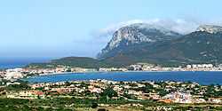
Golfo Aranci
| Golfo Aranci | |
|---|---|
| Comune | |
| Comune di Golfo Aranci | |
 | |
 Golfo Aranci Location of Golfo Aranci in Italy | |
| Coordinates: 41°0′N 9°37′E / 41.000°N 9.617°ECoordinates: 41°0′N 9°37′E / 41.000°N 9.617°E | |
| Country | Italy |
| Region | Sardinia |
| Province | Province of Olbia-Tempio (OT) |
| Frazioni | Baia Caddinas, Marinella, Rudalza |
| Area | |
| • Total | 38.0 km2 (14.7 sq mi) |
| Population (31 December 2004) | |
| • Total | 2,206 |
| • Density | 58/km2 (150/sq mi) |
| Demonym | Golfarancini |
| Time zone | CET (UTC+1) |
| • Summer (DST) | CEST (UTC+2) |
| Postal code | 07020 |
| Dialing code | 0789 |
| Website | Official website |
Golfo Aranci (Gallurese: Figari, Sardinian: Figari) is a comune (municipality) in the Province of Olbia-Tempio in the Italian region Sardinia, located about 200 kilometres (120 mi) north of Cagliari and about 13 kilometres (8 mi) northeast of Olbia.
History
The name of the comune derives probably from a wrong spelling of the Sardinian Golfu di li Ranci ("Gulf of the Crabs"). Once known as Figari, the current town grew up in the mid-18th century as a fishing port. In the early 19th century a Royal Decree made it the main port for the arrivals from the mainland, contributing to its population growth.
Gallery
-

the port
-
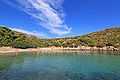
Beach of Cala Moresca
External links
| Wikimedia Commons has media related to Golfo Aranci. |