Goat Island (New York)
 American Falls and Goat Island in winter from the Skylon Tower | |
 Location within the state of New York | |
| Geography | |
|---|---|
| Location | Niagara River |
| Coordinates | 43°04′51″N 79°04′03″W / 43.08083°N 79.06750°WCoordinates: 43°04′51″N 79°04′03″W / 43.08083°N 79.06750°W |
| Highest elevation | 558 ft (170.1 m)[1] |
| Country | |
|
United States | |
| State | New York |
| County | Niagara |
| City | Niagara Falls, New York |
| Additional information | |
| Official website | Official website |
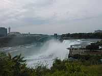


Goat Island (previously called Iris Island) is a small island in the Niagara River, located in the middle of Niagara Falls between the Bridal Veil Falls and the Horseshoe Falls. The island is at the southwest corner of the City of Niagara Falls (and of Niagara County), New York, in the United States and is part of Niagara Falls State Park.
Goat Island has no residents, but is a popular destination for tourists visiting the falls on the U.S. side; it offers some of the most spectacular views available there, in particular at Terrapin Point. Goat Island is connected to the U.S. mainland by two bridges carrying foot, car, and trackless train traffic, and to the smaller Luna Island (adjacent to the American Falls) by a pedestrian bridge. Goat island is largely wooded and is interlaced with foot trails. The Cave of the Winds tour elevator provides access down to the foot of the falls.
Geology
The island was formed geologically during the recent retreat of the falls as it cut inward (upstream) through the Niagara Escarpment. The channel of the Niagara River splits in two above the falls, creating two sets of falls, one on either side of the island. In 1959-60, the eastern side of the island was extended about 8.5 acres (34,000 m2) for additional parking and a helicopter pad. Fill was provided from excavation for the construction of the Robert Moses State Parkway. In 1955 the area between the Terrapin Rocks and Goat Island was filled in, creating Terrapin Point.[2]
In the early 1980s the United States Army Corps of Engineers filled in more land and built diversion dams and retaining walls to force the water away from Terrapin Point. All together 400 feet (120 m) of the Horseshoe Falls was eliminated, including 100 feet (30 m) on the Canadian side. According to author Ginger Strand, the Horseshoe Falls is now entirely in Canada.[3] Other sources say "most of" Horseshoe Falls is in Canada.[4]
The western end of the island is slowly being eroded by the falls and the entire island will eventually disappear as the falls erode further upstream. The waters immediately around Goat Island are relatively shallow and studded with islets and rocks, many of them scenes of dramatic rescues and rescue attempts.
History
John Stedman—an early pioneer and miller—kept a herd of goats on the island. Upon returning to the island after the terrible winter of 1780, Stedman found all but one of the goats had died, thus giving the island its name.
The preservation of the island as parkland is due to the early efforts of Augustus Porter, who in the middle 19th century recognized the long-term value of the falls as a tourist attraction. Porter purchased the island and later allowed a group of Tuscarora Native Americans to live on the island and sell their crafts to the tourists who came to the falls by stagecoach and early railroads. In spite of pressure, Porter refused to tame the environment on the island. In 1817, he built a toll bridge to the island for tourists. It was swept away by ice, so another was built the following year downstream. Basil Hall called it "one of the most singular pieces of engineering in the world". Almost seven hundred feet long, it soon became the best-travelled walkway in the region.
In 1885 the island was included in the Niagara Reservation State Park which is the oldest state park in the U.S.
Botany
In 1879 landscape architect Frederick Law Olmsted, wrote that he had travelled four thousand miles throughout the continent "without finding elsewhere the same quality of forest beauty which was once abundant about the falls, and which is still to be observed in those parts of Goat Island where the original growth of trees and shrubs had not been disturbed..." Olmsted concluded that the spray from the Falls created a natural nursery for indigenous plant life. Since that time, regular mowing of the Goat Island meadow, heavy foot traffic, and the incursion of invasive species have significantly altered the floral landscape of the island.[5]
Tesla Monument
The island is home to the Tesla Monument which honors the Serbian-American inventor, Nikola Tesla. The statue was a given to the United States by the government of Yugoslavia in 1976. The sculptor of the statue is Frano Kršinić (1897–1982), a renowned Yugoslav sculptor.[6]
In fiction
Part of H. G. Wells's 1908 novel The War in the Air is set on Goat Island. During the fictional invasion of the US by the forces of Imperial Germany, depicted in the book, the protagonist is stranded on the island, with bridges to the mainland destroyed in the fighting, and is involved in a grim battle for survival with two equally stranded German soldiers.
References
- ↑ U.S. Geological Survey Geographic Names Information System: Goat Island
- ↑ Berton, Pierre (2009). Niagara: A History of the Falls. SUNY Press. pp. 20–21. ISBN 978-1-4384-2928-1. Retrieved 1 December 2010.
- ↑ Strand, Ginger (2009). Inventing Niagara: Beauty, Power, and Lies. Simon and Schuster. p. 195. ISBN 978-1-4165-4657-3. Retrieved 1 December 2010.
- ↑ Vanderwilt, Dirk (2007). Niagara Falls: With the Niagara Parks, Clifton Hill, and Other Area Attractions, p. 35. Channel Lake, Inc., ISBN 978-0-9792043-7-1
- ↑ http://www.mobot.org/plantscience/ResBot/flor/Bot_Goat/02_Contents.htm
- ↑ Tesla Memorial Society of New York
External links
- Historic and Current Images of Goat Island Niagara Falls Public Library (Ont.)
- 1853 accident at Niagara Falls