Gmina Garbów
| Gmina Garbów Garbów Commune | ||
|---|---|---|
| Gmina | ||
| ||
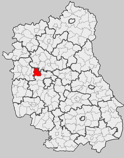 Location within the county and voivodeship | ||
| Coordinates (Garbów): 51°21′1″N 22°20′24″E / 51.35028°N 22.34000°ECoordinates: 51°21′1″N 22°20′24″E / 51.35028°N 22.34000°E | ||
| Country |
| |
| Voivodeship | Lublin | |
| County | Lublin County | |
| Seat | Garbów | |
| Area | ||
| • Total | 102.42 km2 (39.54 sq mi) | |
| Population (2006) | ||
| • Total | 8,969 | |
| • Density | 88/km2 (230/sq mi) | |
| Website | http://www.garbow.ug.gov.pl/ | |
Gmina Garbów is a rural gmina (administrative district) in Lublin County, Lublin Voivodeship, in eastern Poland. Its seat is the village of Garbów, which lies approximately 20 kilometres (12 mi) north-west of the regional capital Lublin.
The gmina covers an area of 102.42 square kilometres (39.5 sq mi), and as of 2006 its total population is 8,969.
Neighbouring gminas
Gmina Garbów is bordered by the gminas of Abramów, Jastków, Kamionka, Markuszów, Nałęczów and Niemce.
Villages
The gmina contains the following villages with the status of sołectwo: Bogucin, Borków, Garbów (divided into two sołectwos: Garbów I and Garbów II), Gutanów, Janów, Karolin, Leśce, Meszno, Piotrowice-Kolonia, Piotrowice Wielkie, Przybysławice, Wola Przybysławska (divided into two sołectwos: Wola Przybysławska I and Wola Przybysławska II), and Zagrody.
References
| ||||||||||||
| ||||||||||||||||