Glogghüs
| Glogghüs | |
|---|---|
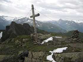 Summit of Glogghüs | |
| Elevation | 2,534 m (8,314 ft) |
| Prominence | 554 m (1,818 ft)[1] |
| Listing | Alpine mountains 2500-2999 m |
| Location | |
 Glogghüs Location in Switzerland | |
| Location | Obwalden/Bern, Switzerland |
| Range | Urner Alps |
| Coordinates | 46°45′50.8″N 08°15′31″E / 46.764111°N 8.25861°ECoordinates: 46°45′50.8″N 08°15′31″E / 46.764111°N 8.25861°E |
The Glogghüs is a mountain of the Urner Alps, located on the border between the Swiss cantons of Obwalden and Bern. On its northern side it overlooks the Melchsee and the village of Melchsee-Frutt.
References
- ↑ Retrieved from the Swisstopo topographic maps and Google Earth. The key col is located east of the Tannensee at 1,980 metres.