Glenwood, Edmonton
| Glenwood | |
|---|---|
| Neighbourhood | |
 Glenwood Location of Glenwood in Edmonton | |
| Coordinates: 53°32′10″N 113°36′14″W / 53.536°N 113.604°W | |
| Country |
|
| Province |
|
| City | Edmonton |
| Quadrant[1] | NW |
| Ward[1] | 1 |
| Sector[2] | Mature area |
| Area[3][4] | Jasper Place |
| Government[5] | |
| • Administrative body | Edmonton City Council |
| • Councillor | Linda Sloan |
| Area[6] | |
| • Total | 1.77 km2 (0.68 sq mi) |
| Elevation | 677 m (2,221 ft) |
| Population (2012)[7] | |
| • Total | 5,095 |
| • Density | 2,878.5/km2 (7,455/sq mi) |
| • Change (2009–12) |
|
| • Dwellings | 2,437 |
Glenwood is a large neighbourhood in west Edmonton, Alberta, Canada. The neighbourhood has a mixture of residential and commercial development. Glenwood became a part of Edmonton in 1964 when the Town of Jasper Place amalgamated with Edmonton.
The neighbourhood is bounded on the north by Stony Plain Road, on the south by 95 Avenue, on the east by 156 Street and on the west by 170 Street.
The Edmonton Transit System's Jasper Place terminal is located at the north east corner of the neighbourhood.
The Edmonton Police Service west Edmonton headquarters is located in the north end of the neighbourhood at 100th Avenue and 165 Street.
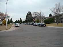
 Residential street in Glenwood |
Demographics
In the City of Edmonton's 2012 municipal census, Glenwood had a population of 5,095 living in 2,437 dwellings,[7] a 3.5% change from its 2009 population of 4,921.[8] With a land area of 1.77 km2 (0.68 sq mi),[6] it had a population density of 2,878.5 people/km2 in 2012.[6][7]
Residential development
Much of Glenwood was developed in the 35 years following the end of World War II, with three out of four residences being built between 1946 and 1980. Almost half (49%) of the residences are single-family dwellings, with an almost equal proportion (46%) of apartments. Another 4% of residences are duplexes,[9] with 2% of the residences being row houses. Over half (55%) or residences are rented, with just under half (45%) being owner occupied.[10][11][12]
Schools
There are six schools located in Glenwood. Three are operated by the Edmonton Public School System, one is operated by the Edmonton Catholic School System, and two are independent.
Edmonton Public Schools
- Glendale Elementary School
- Meadowlark Christian School (Former Our Lady of Fatima Catholic School)
- Westlawn Junior High School
Edmonton Catholic Schools
- St. Thomas More Junior High School
Independently Operated Schools
- Britannia A M I Montessori School
- Crestwood Montessori School
The Edmonton Public School System's Jasper Place High School and the Edmonton Catholic School System's St. Francis Xavier High School are both located just to the south of Glenwood in the neighbourhood of West Meadowlark Park.
The Centre for the Arts Campus (formerly Jasper Place Campus) of MacEwan College is located just to the east of Glenwood in the adjacent neighbourhood of West Jasper Place.
Surrounding neighbourhoods
 |
Stone Industrial | Britannia Youngstown | Canora |  |
| Terra Losa, Place LaRue | |
West Jasper Place | ||
| ||||
| | ||||
| Summerlea | Meadowlark Park, West Meadowlark Park | Sherwood |
References
- ↑ 1.0 1.1 "City of Edmonton Wards & Standard Neighbourhoods" (PDF). City of Edmonton. Retrieved February 13, 2013.
- ↑ "Edmonton Developing and Planned Neighbourhoods, 2011" (PDF). City of Edmonton. Retrieved February 13, 2013.
- ↑ "The Way We Grow: Municipal Development Plan Bylaw 15100" (PDF). City of Edmonton. 2010-05-26. Retrieved February 13, 2013.
- ↑ "City of Edmonton Plans in Effect" (PDF). City of Edmonton. November 2011. Retrieved February 13, 2013.
- ↑ "City Councillors". City of Edmonton. Retrieved February 13, 2013.
- ↑ 6.0 6.1 6.2 "Neighbourhoods (data plus kml file)". City of Edmonton. Retrieved February 13, 2013.
- ↑ 7.0 7.1 7.2 "Municipal Census Results – Edmonton 2012 Census". City of Edmonton. Retrieved February 22, 2013.
- ↑ "2009 Municipal Census Results". City of Edmonton. Retrieved February 22, 2013.
- ↑ Includes triplexes and quadruplexes.
- ↑ http://censusdocs.edmonton.ca/DD23/FEDERAL%202001/Neighbourhood/GLENWOOD.pdf
- ↑ http://censusdocs.edmonton.ca/C05002/MUNICIPAL%202005/Neighbourhood/GLENWOOD.pdf
- ↑ http://censusdocs.edmonton.ca/DD22/FEDERAL%202001/Neighbourhood/GLENWOOD.pdf