Glatton
Coordinates: 52°27′36″N 0°18′07″W / 52.460°N 0.302°W

Glatton – in Huntingdonshire (now part of Cambridgeshire), England – is a village near Conington south of Yaxley and Stilton. A World War II airfield known as RAF Glatton was built nearby and is now known as Peterborough's Conington Airport. In 1881 Glatton had a male population of 126 and a female population of 123, making for a total population of 249.[1]
In the 1870s, John Marius Wilson described Glatton as:
- "GLATTON, a village and a parish in the district of Peterborough and county of Huntingdon. The village stands 3 miles SSW of Stilton, and 3 ½ WSW of Holme r. station."[2]
Population
By 2011 Glatton had a population of 308 according to the 2011 census.[3]
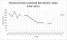
Of the population of 308, 35 people are in the 0-19 age cohort, 62 people are in the 20-44 age cohort, 142 are in the 45-74 age cohort and 79 people are over 75 years old. This is an age structure which is weighted on the side of the older population; 72% of the population is above 45 years old. [4] Census records for Glatton, beginning from 1801 at 323 people, show slight fluctuations however a steady decline in people can be seen until 1951 with 136 people living in Glatton. After this, the population goes up relatively swiftly.[5][6]

It is unclear what caused the population to go down and then up again, there has been no boundary change for Glatton parish since the census recordings began which means population change would most likely be due to migration.[7]
Occupation
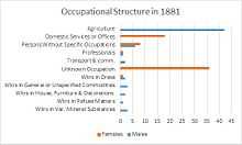
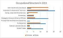
In 1881 there is a clear gender divide in occupations. Most men work in Agriculture (74%), with a fairly even spread among other occupation. Most women have unknown occupations or work in domestic services/ offices.[8] 130 years later, in the 2011 census, there is a distinct change in livelihoods. Both men and women have their highest levels of employment in Associate Professional and technical occupations, there are also a far greater number of people working in Management or as Professionals. There is still a degree of gender specific employment, for example Administrative and Secretarial jobs employ far more women (ratio = 5:1) and far more men work in the Skilled Trade sector of employment (ratio = 4:1). However men and women are represented more evenly across all the occupation types in the latter census. Agricultural and Domestic professions, the most common known occupations in 1881, are non existent in 2011.[9]


Local Amenities
Religion
Glatton has a local Church of England parish called St Nicholas which is part of the Diocese of Ely.[10] The church is mentioned in the 1086 Domesday book however non of the original building now remains. A notable feature of the church is its tower which was built in about 1500 AD, its four bells have the following inscriptions: 1) COMM COMM AND PREAY 1595. 2) SEARVE GOD AND OBEAY THY PRINCE 1595. 3) J.TAYLOR & CO FOUNDERS LOUGHBOROUGH 1863. 4) OMNIA FAINT AD GLORIAM DEI SOLI THO. EAYRE 1736.[11]
Education
There are no schools in Glatton. The closest primary school is Stilton CofE VC Primary School in Stilton and is 1.8 miles away. The closest secondary school is Sawtry Community College in Sawtry which is 2.1 miles away.[12]
Listed buildings
There are a number of listed buildings in Glatton,[13] among them is St Nicholas' Church and Addison Arms Public House which is also functional and won the Rural Pub of The Year award in Huntingdonshire in 2014.[14]
Transport
The A1 is the closest motorway and is about a mile to the East of Glatton parish. There is a rail line that runs about 3 miles to the east of Glatton however the closest station is in Peterborough and this is about 10 miles away.[15]
References
- ↑ Wilson, John Marius (1870-72). Gazetteer of England and Wales. Edinburgh: A. Fullerton & Co. Retrieved 4 February 2015. Check date values in:
|date=(help) - ↑ Wilson, John Marius (1870-72). Gazetteer of England and Wales. Edinburgh: A. Fullerton & Co. Retrieved 4 February 2015. Check date values in:
|date=(help) - ↑ "Glatton (Parish): Key Figures for 2011 Census: Key Statistics". Neighbourhood Statistics. Office for National Statistics. Retrieved 2015-01-27.
- ↑ "Glatton (Parish): Age Structure, 2011". Neighbourhood Statistics. Office for National Statistics. Retrieved 10 April 2015.
- ↑ "Population change in Glatton". Neighbourhood Statistics. Retrieved 22 April 2015.
- ↑ "Enumeration Abstract". Online Historical Population Reports. Retrieved 22 April 2015.
- ↑ Wilson, John Marius (1870-72). Gazetteer of England and Wales. Edinburgh: A. Fullerton & Co. Retrieved 26 April 2015. Check date values in:
|date=(help) - ↑ Wilson, John Marius (1870-72). Gazetteer of England and Wales. Edinburgh: A. Fullerton & Co. Retrieved 26 April 2015. Check date values in:
|date=(help) - ↑ "Glatton (parish): Occupation Males/ Females 2011". Neighbourhood Statistics. Office for National Statistics. Retrieved 24 April 2015.
- ↑ "Parish of Glatton: St Nicholas". Parish Finder. Church Commissioners for England. Retrieved 27 April 2015.
- ↑ "Glatton Parish and Community". Word Press. Retrieved 27 April 2015.
- ↑ "Schools near Glatton". School Finder. RM education. Retrieved 27 April 2015.
- ↑ "History in Structure". British Listed Buildings. BritishListedBuiuldings.co.uk. Retrieved 27 April 2015.
- ↑ "Addison Arms local website". The Addison Arms. Retrieved 27 April 2015.
- ↑ "Maps". Google maps. Basarsoft. Retrieved 27 April 2015.
External links
![]() Media related to Glatton at Wikimedia Commons
Media related to Glatton at Wikimedia Commons
Glatton Village Official website www.glatton.org.uk
