Giske (island)
 | |
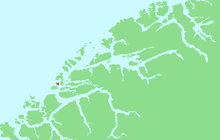 Location in Møre og Romsdal | |
| Geography | |
|---|---|
| Location | Møre og Romsdal, Norway |
| Coordinates | 62°30′18″N 6°2′53″E / 62.50500°N 6.04806°ECoordinates: 62°30′18″N 6°2′53″E / 62.50500°N 6.04806°E |
| Area | 2.67 km2 (1.03 sq mi) |
| Length | 2.5 km (1.55 mi) |
| Width | 2.5 km (1.55 mi) |
| Highest elevation | 23 m (75 ft) |
| Country | |
| County | Møre og Romsdal |
| Municipality | Giske Municipality |
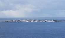
Giske is an island in Giske Municipality in Møre og Romsdal county, Norway. It covers an area of 2.67 square kilometers (1.03 sq mi) and had 717 residents in 2010. It is flat, with the highest point 23 meters (75 ft) above mean sea level. The island is connected by the Giske Bridge to the neighboring island of Valderøya to the east and by the Godøy Tunnel to the island of Godøy to the southwest. Giske Church, dating back to the year 1180, sits on the southern coast of the island.[1]
The 0.75-square-kilometre (190-acre) village of Giske is the main "urban area" on the island. Giske village has a population (2013) of 735, giving the village a population density of 980 inhabitants per square kilometre (2,500/sq mi).[2] The rest of the island's residents are spread out around the village on farms.
References
- ↑ "Øyriket Giske" (in Norwegian). Giske Municipality. Retrieved 12 September 2011.
- ↑ Statistisk sentralbyrå (1 January 2013). "Urban settlements. Population and area, by municipality.".
External links
 Media related to Giske at Wikimedia Commons