Gipcy
| Gipcy | |
|---|---|
|
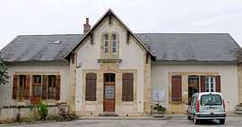
The town hall in Gipcy | |
 Gipcy | |
|
Location within Auvergne region  Gipcy | |
| Coordinates: 46°30′12″N 3°03′18″E / 46.5033°N 3.055°ECoordinates: 46°30′12″N 3°03′18″E / 46.5033°N 3.055°E | |
| Country | France |
| Region | Auvergne |
| Department | Allier |
| Arrondissement | Moulins |
| Canton | Souvigny |
| Intercommunality | Bocage Sud |
| Government | |
| • Mayor (2008–2014) | Denis Villechenon |
| Area1 | 27.57 km2 (10.64 sq mi) |
| Population (2008)2 | 218 |
| • Density | 7.9/km2 (20/sq mi) |
| INSEE/Postal code | 03122 / 03210 |
| Elevation |
244–433 m (801–1,421 ft) (avg. 385 m or 1,263 ft) |
|
1 French Land Register data, which excludes lakes, ponds, glaciers > 1 km² (0.386 sq mi or 247 acres) and river estuaries. 2 Population without double counting: residents of multiple communes (e.g., students and military personnel) only counted once. | |
Gipcy is a commune in the Allier department in central France.
Population
| Historical population | ||
|---|---|---|
| Year | Pop. | ±% |
| 1962 | 318 | — |
| 1968 | 382 | +20.1% |
| 1975 | 303 | −20.7% |
| 1982 | 292 | −3.6% |
| 1990 | 273 | −6.5% |
| 1999 | 233 | −14.7% |
| 2008 | 218 | −6.4% |
See also
References
| Wikimedia Commons has media related to Gipcy. |