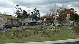
Gin Gin, Queensland
| Gin Gin Queensland | |||||||||||||
|---|---|---|---|---|---|---|---|---|---|---|---|---|---|
|
Bruce Highway passing through Gin Gin | |||||||||||||
 Gin Gin | |||||||||||||
| Coordinates | 24°59′27″S 151°57′21″E / 24.99083°S 151.95583°ECoordinates: 24°59′27″S 151°57′21″E / 24.99083°S 151.95583°E | ||||||||||||
| Population | 1,190 (2011 census)[1] | ||||||||||||
| Postcode(s) | 4671 | ||||||||||||
| Location |
| ||||||||||||
| LGA(s) | Bundaberg Region | ||||||||||||
| State electorate(s) | Callide | ||||||||||||
| Federal Division(s) | Flynn | ||||||||||||
| |||||||||||||
Gin Gin is a small town and rural locality in the Bundaberg Region, Queensland, Australia.[2][3]
It is located on the Bruce Highway, approximately 51 kilometres (32 mi) west of Bundaberg and 370 kilometres (230 mi) north-west of Brisbane, the state capital. The town owes its existence to its strategic location about halfway between Brisbane and Rockhampton. It is often used as a stop-over point for drivers travelling between these two centres. In the 2011 census, Gin Gin had a population of 1,190 people.[1]
History
The town name Gin Gin was derived from the original station name, which used a local Aboriginal word indicating "red soil thick scrub".[2][3][4]
The Gin Gin district was originally settled in 1847 when Gregory Blaxland and William Forster moved into the area with sheep and cattle. The site where the town now stands was once part of the sprawling Gin Gin Station owned by Sir Thomas McIlwraith, who was Premier of Queensland three times between 1879 and 1893.
The Gin Gin district is nicknamed Wild Scotsman Country due to the capture of one of Queensland's few bushrangers, James Alpin McPherson, in the area on 30 March 1866. McPherson, who went by the same nickname, was captured at Monduran Station, 13 kilometres (8.1 mi) north of town.
Gin Gin Post Office opened on 15 March 1875.[5]
Gin Gin Provisional School opened on 26 June 1882. It closed on 31 October 1890 to replaced by Gin Gin State School which opened on 3 November 1890 with 8 students under teacher Arthur William Moore. In 1956, the school expanded to offer secondary schooling, until a separate Gin Gin State High School was established on 1 February 1972. Gin Gin State Pre-School opened on 25 October 1977 and closed in 2006 when it was absorbed into Gin Gin State School.[6][7][8][9][10]
Heritage listings
Gin Gin has a number of heritage-listed sites, including:
- Boolboonda Tunnel Road: Boolboonda State Primary School (former)[11]
- Mulgrave Street: Gin Gin Railway Station and Complex[12]
- Tunnel Road: Boolboonda Tunnel[13]
Economy
Gin Gin, like Bundaberg, is heavily dependent on the sugar industry, with sugarcane plantations dotted throughout the area. The Gin Gin Sugar Mill is situated at the nearby locality of Wallaville. An extensive system of sugar cane tramways service the area.[14] Cattle production also features prominently. In recent years small cropping has taken off across farms in the district, with varied success.
Education
Gin Gin State School opened in 1882 with only one teacher in one building. Now it caters for around 450 students, mainly of rural background. As well as the students from Gin Gin itself, many students travel, mainly by bus, from surrounding properties and townships like Wallaville, Bullyard, Tirroan, McIlwraith, Maroondan and Mount Perry.
Events
The Wild Scotsman Festival used to be held in Gin Gin on the third week of March each year to commemorate the capture of the bushranger James MacPherson.[15] The Wild Scotsman Markets are held next to the historical Grounds each Saturday morning.
In popular culture
Gin Gin is the eighteenth town mentioned in the original (Australian) version of the song "I've Been Everywhere".
Population data
At the 2006 census, Gin Gin had a population of 892.[16]
See also
References
- ↑ 1.0 1.1 Australian Bureau of Statistics (31 October 2012). "Gin Gin (SSC)". 2011 Census QuickStats. Retrieved 23 June 2014.
- ↑ 2.0 2.1 "Gin Gin (town) (entry 13801)". Queensland Place Names. Queensland Government. Retrieved 23 June 2014.
- ↑ 3.0 3.1 "Gin Gin (entry 44721)". Queensland Place Names. Queensland Government. Retrieved 23 June 2014.
- ↑ It has usage of the duplicated place names in various parts of Australia - same sounding but different rendering is the place in Western Australia - Gingin, Western Australia
- ↑ Premier Postal History. "Post Office List". Premier Postal Auctions. Retrieved 10 May 2014.
- ↑ "Opening and closing dates of Queensland Schools". Queensland Government. Retrieved 23 June 2014.
- ↑ "Agency ID5238, Gin Gin State School". Queensland State Archives. Retrieved 24 June 2014.
- ↑ "Agency ID4901, Gin Gin State High School". Queensland State Archives. Retrieved 24 June 2014.
- ↑ "Agency ID52, Gin Gin State Pre-School". Queensland State Archives. Retrieved 24 June 2014.
- ↑ Queensland Family History Society (2010), Queensland schools past and present (Version 1.01 ed.), Queensland Family History Society, ISBN 978-1-921171-26-0
- ↑ "Boolboonda State Primary School (former) (entry 16993)". Queensland Heritage Register. Queensland Heritage Council. Retrieved 2013-07-07.
- ↑ "Gin Gin Railway Station and Complex (entry 16412)". Queensland Heritage Register. Queensland Heritage Council. Retrieved 2013-07-07.
- ↑ "Boolboonda Railway Tunnel (entry 16279)". Queensland Heritage Register. Queensland Heritage Council. Retrieved 2013-07-07.
- ↑ The Gin Gin Central Mill Tramway Armstrong, J. Australian Railway Historical Society Bulletin, March, 1975 pp53-69
- ↑ "Gin Gin". Sydney Morning Herald. 8 Feb 2004. Retrieved 23 June 2014.
- ↑ Australian Bureau of Statistics (25 October 2007). "Gin Gin (L) (Urban Centre/Locality)". 2006 Census QuickStats. Retrieved 13 May 2011.
External links
![]() Media related to Gin Gin, Queensland at Wikimedia Commons
Media related to Gin Gin, Queensland at Wikimedia Commons
| ||||||||||||||
