Gilwern
Gilwern is a village in Monmouthshire, Wales.[1] The name translates from the Welsh Y Gilwern (from cil-gwern) as "the recess (or bend) of the alders",[2] probably a reference to its position at the point where the Clydach Gorge opens out into the Usk Valley and the River Clydach flows into a sharp bend in the River Usk. It is within the Llanelly parish ward of Monmouthshire County Council, just off the A465 road 3.5 miles (5.6 km) west of the market town of Abergavenny.
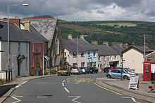
Attractions
Gilwern stands on the edge of the Brecon Beacons National Park. The local area has a history of iron and lime production.[3] The Monmouthshire and Brecon Canal, which has a wharf at Gilwern, was built to transport coal, limestone and iron products from the surrounding area using a network of tramways and railroads. The Clydach Railroad and the Llam-march Tramroad both serviced the wharf with materials gathered and produced further up the Clydach Gorge. Both are still visible, the former being a road and the latter a footpath between Gilwern and Clydach. The canal crosses the River Clydach on the Gilwern Aqueduct, an embankment over 90 feet high[4] just next to Gilwern Wharf.
Gilwern Hill lies to the south of the village.
References
- ↑ http://www.wales-tourist-information.co.uk/town/Monmouthshire/Gilwern/index.html
- ↑ http://www.ordnancesurvey.co.uk/oswebsite/docs/ebooks/guide-to-welsh-origins-of-place-names.pdf
- ↑ http://www.ggat.org.uk/cadw/historic_landscape/clydach_gorge/english/clydach_008.htm
- ↑ http://www.visitoruk.com/Abergavenny/gilwern-C592-V3122.html
External links
| Wikimedia Commons has media related to Gilwern. |
Coordinates: 51°50′N 3°05′W / 51.833°N 3.083°W