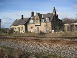
Gilsland railway station
| Gilsland | |
|---|---|
|
Station buildings in April 2010. | |
| Location | |
| Place | Gilsland |
| Area | City of Carlisle |
| Coordinates | 54°59′26″N 2°34′12″W / 54.9905°N 2.5699°WCoordinates: 54°59′26″N 2°34′12″W / 54.9905°N 2.5699°W |
| Grid reference | NY636663 |
| Operations | |
| Original company | Newcastle and Carlisle Railway |
| Pre-grouping | North Eastern Railway |
| Post-grouping | London and North Eastern Railway |
| Platforms | 2 |
| History | |
| 19 July 1836 | Station opened as "Rose Hill" |
| 1 May 1869 | Renamed |
| 5 April 1965 | Closed to goods |
| 2 January 1967 | Closed to passengers |
| Disused railway stations in the United Kingdom | |
|
Closed railway stations in Britain A B C D–F G H–J K–L M–O P–R S T–V W–Z | |
| UK Railways portal | |
Gilsland railway station was a railway station on the Newcastle and Carlisle Railway, on the Carlisle to Hexham section.[1] It was situated near the centre of the village of Gilsland.
History
The line became part of the North Eastern Railway on 17 July 1862, then, at grouping in 1923, it became part of the London and North Eastern Railway.[2]
The station was originally opened on 19 July 1836 when it was known as "Rose Hill".[3][4] It was renamed "Gilsland" on 1 May 1869 and, after having been proposed for closure in the Beeching report,[5] closed to passengers on 2 January 1967.[6][4] Goods facilities were withdrawn on 5 April 1965.[7]
| Preceding station | Historical railways | Following station | ||
|---|---|---|---|---|
| Low Row Line open, station closed |
North Eastern Railway Newcastle and Carlisle Railway |
Greenhead Line open, station closed | ||
Proposed reopening
The potential for the station's reopening was assessed in 2001 and in 2005 in the Tyne Valley Route Strategy.[8] Neither study found that there was a case for reopening, although potential demand was assessed only in relation to the local population and not with regard to possible visitors to Hadrian's Wall.[8] In May 2013, it was reported that the Tyne Valley Rail Users Group had asked JMP Consultants to assess the potential for the reopening of the station to provide access to Hadrian's Wall.[8][9][10] The report was published in August 2013 and concluded that there is an economic case for reopening the station if spending by additional visitors to the area is taken into account.
References
Notes
- ↑ Conolly 2004, p. 27, section B1.
- ↑ Awdry 1990, pp. 150, 153.
- ↑ Butt 1995, p. 199.
- ↑ 4.0 4.1 Quick 2009, p. 184.
- ↑ Beeching 1963, p. 113.
- ↑ Butt 1995, pp. 102, 199.
- ↑ Clinker 1988, p. 52.
- ↑ 8.0 8.1 8.2 Nigel Harris, ed. (17–30 April 2013). "Study begins into 'Hadrian's station'". RAIL (720): 11.
- ↑ Tulip, Joseph (22 March 2013). "Gilsland: Station could be on track to reopen". News and Star. Retrieved 23 January 2013.
- ↑ JMP Consultants (20 March 2013). "A new rail station at Gilsland for Hadrian’s Wall?". Retrieved 2013-05-26.
Sources
- Awdry, Christopher (1990). Encyclopaedia of British Railway Companies. Sparkford: Patrick Stephens Ltd. ISBN 1-8526-0049-7. OCLC 19514063.
- Beeching, Richard (1963). "The Reshaping of British Railways" (PDF). HMSO.
- Butt, R. V. J. (1995). The Directory of Railway Stations: details every public and private passenger station, halt, platform and stopping place, past and present (1st ed.). Sparkford: Patrick Stephens Ltd. ISBN 1-8526-0508-1. OCLC 60251199.
- Clinker, C.R. (1988) [1978]. Clinker's Register of Closed Passenger Stations and Goods Depots in England, Scotland and Wales 1830–1980 (2nd ed.). Bristol: Avon-Anglia Publications & Services. ISBN 0-905466-91-8. OCLC 655703233.
- Conolly, W. Philip (2004) [1958]. British Railways Pre-Grouping Atlas and Gazetteer. Hersham, Surrey: Ian Allan. ISBN 978-0-7110-0320-0.
- Quick, Michael (2009) [2001]. Railway passenger stations in Great Britain: a chronology (4th ed.). Oxford: Railway and Canal Historical Society. ISBN 978 0 901461 57 5. OCLC 612226077.
External links
- Campaign to Open Gilsland Station - Website with Feasibility Study download
- Gilsland station on a navigable 1955 O.S. map
| ||||||||||||||||||||||||||||||||||||||||||||||||||||||||||
