Gilgit-Baltistan
| Gilgit-Baltistan گلگت بلتستان | |||
|---|---|---|---|
| Administrative Territory of Pakistan[1] | |||
| |||
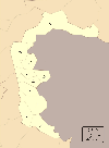
_(claims_hatched).svg.png) Gilgit-Baltistan (minus the Siachen Glacier area) is shown in red. Rest of Pakistan is shown in white. The Indian-administered state of Jammu and Kashmir is shown by hatching. | |||
| Coordinates: 35°21′N 75°54′E / 35.35°N 75.9°ECoordinates: 35°21′N 75°54′E / 35.35°N 75.9°E | |||
| Country |
| ||
| Political entity | Gilgit-Baltistan | ||
| Established | 1 July 1970 | ||
| Capital | Gilgit | ||
| Largest city | Gilgit | ||
| Government | |||
| • Type | Self-governing territory of Pakistan | ||
| • Body | Legislative assembly | ||
| • Governor | Chaudhry Muhammad Barjees Tahir[2] | ||
| • Chief Minister | Sher Jahan Mir[3] | ||
| Area | |||
| • Total | 72,971 km2 (28,174 sq mi) | ||
| Population (2008; est.) | |||
| • Total | 1,800,000 | ||
| • Density | 25/km2 (64/sq mi) | ||
| Time zone | PKT (UTC+5) | ||
| ISO 3166 code | PK-GB | ||
| Main languages |
and Kohistani | ||
| Assembly seats | 33[4] | ||
| Districts | 7 | ||
| Towns | 9 | ||
| Website | Gilgit-Baltistan Government | ||
Gilgit-Baltistan (Urdu/Shina/Burushaski: گلگت بلتستان, Balti: གིལྒིཏ་བལྟིསྟན formerly known as the Northern Areas[5]) is the northernmost administrative territory of Pakistan.[6] It borders Azad Kashmir to the south, the province of Khyber Pakhtunkhwa to the west, the Wakhan Corridor of Afghanistan to the north, the Xinjiang autonomous region of China to the east and northeast and Jammu and Kashmir to the southeast.
Internationally the region together with Azad Kashmir is claimed to be "disputed" by India and Pakistan.[6]
Gilgit-Baltistan is an autonomous[7] self-governing region that was established as a single administrative unit in 1970, formed by the amalgamation of the Gilgit Agency, the Baltistan region and the former princely states of Hunza and Nagar. It covers an area of 72,971 km² (28,174 sq mi) and is highly mountainous. It has an estimated population approaching 1,000,000. Its capital city is Gilgit (population 216,760).
History
Gilgit-Baltistan was ruled by local rulers who converted to Islam from Hinduism and Buddhism in the 14th century.The territory became predominantly Muslim between 15th and 16th century and later during the Mughal Empire due to missionary Sufi saints whose dargahs dot the landscape. By 1757, suzerainty of the region was obtained from the Mughals by Ahmad Shah Durrani under an agreement[8] and became part of Durrani Empire[9] later known as the Afghanistan[10][11][12] until Ranjit Singh invaded and took control from the Afghans in 1819.[13] After the defeat of the Sikhs in the first Anglo-Sikh war, it became a a part of the princely state with the name "Jammu and Kashmir" in 1846 under the rule of the Dogras who ruled the more than a century. It remained so till a rebellion, organised by a mutineered Major Brown of the Gilgit Scouts overthrew Ghansara Singh, the Governor administering the region on behalf of the Maharaja of Jammu and Kashmir on 1 November 1947, and temporarily installed an unrecognized state of their own. Raja Shah Rais Khan became the President while Mirza Hassan Khan the Commander-in-Chief of the Gilgit scouts. The region had run its own government for 16 days but later on the approval of local residents, unconditionally offered Pakistan to take over the administration.[14][15] Also After Pakistan's independence, Jammu and Kashmir initially remained an independent state. Later On 22 October 1947, due to India's interest towards the Muslim majority state of Jammu and Kashmir, Pakistani armed forces crossed the border in Jammu and Kashmir with the claim that they needed to suppress a rebellion on the southeast of the kingdom. Local tribal militias and the Pakistani armed forces moved to take Srinagar but on reaching Uri they encountered defensive forces. Hari Singh made a plea to India for assistance and signed the Instrument of Accession. The British government also took part in stopping the Pakistani forces from advancing.[16] On 20 January 1948, the UN passed a resolution which called for the withdrawal of all Pakistani forces from Jammu and Kashmir,[17] however a part of it (Known as Azad Kashmir) has remained under the control of Pakistan since then.[18] In 1970 the two part territory was merged into a single administrative unit, and given the name the name "Northern Areas".[6] The name "Northern Areas" was actually first used by the United Nations to refer to the northern areas of Kashmir. The Shaksgam tract was ceded by Pakistan to China following the signing of the Sino-Pakistani Frontier Agreement in 1963.[19][20]
Before the demise of Shribadat, the last Hindu king of the Trakhàn dynasty in Gilgit, a group of Shin people migrated from Gilgit Dardistan and settled in the Dras and Kharmang areas. The descendants of those Dardic people can be still found today, and is believed that they have maintained their Dardic culture and Shina language up to the present time.
Government
The territory of present-day Gilgit-Baltistan became a separate administrative unit in 1970 under the name "Northern Areas". It was formed by the amalgamation of the former Gilgit Agency, the Baltistan District of the Ladakh Wazarat, and the hill states of Hunza and Nagar. It presently consists of nine districts, has a population approaching one million, an area of approximately 28,000 square miles (73,000 km2), and shares borders with Pakistan, China, Afghanistan, and India. In 1993, an attempt was made by the High Court of Azad Jammu and Kashmir to annex Gilgit-Baltistan but was quashed by the Supreme Court of Pakistan after protests by the locals of Gilgit-Baltistan, who feared domination by the Kashmiris.[21]
While administratively controlled by Pakistan since the First Kashmir War, Gilgit-Baltistan has never been formally integrated into the Pakistani state and does not participate in Pakistan's constitutional political affairs.[22][23] On 29 August 2009, the Gilgit-Baltistan Empowerment and Self-Governance Order 2009, was passed by the Pakistani cabinet and later signed by the then President of Pakistan Asif Ali Zardari.[24] The order granted self-rule to the people of Gilgit-Baltistan, by creating, among other things, an elected Gilgit-Baltistan Legislative Assembly and Gilgit-Baltistan Council. Gilgit-Baltistan thus gained a de facto province-like status without constitutionally becoming part of Pakistan.[7][22] Officially, Pakistan has rejected Gilgit-Baltistani calls for integration with Pakistan on the grounds that it would prejudice its international obligations with regard to the Kashmir conflict.[21] Some militant Kashmiri nationalist groups, such as the Jammu and Kashmir Liberation Front, claim Gilgit-Baltistan as part of a future independent state to match what existed in 1947.[21] India, on the other hand, maintains that Gilgit-Baltistan is a part of the Indian controlled state of Jammu and Kashmir.[25]
Administrative divisions
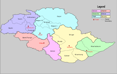
Gilgit-Baltistan is administratively divided into two divisions which, in turn, are divided into nine districts, consisting of the four Baltistan districts of Skardu, Shigar, Kharmang, and Ghanche, and the five Gilgit districts of Gilgit, Ghizer, Diamer, Astore, and Hunza-Nagar.[26] The principal administrative centers are the towns of Gilgit and Skardu.
| Division | District | Area (km²) | Capital | Population (1998) | Divisional Capital |
|---|---|---|---|---|---|
| Baltistan | Ghanche | 9,400 | Khaplu | 90,000 | Skardu |
| Shigar | NA | Shigar | NA | ||
| Kharmang | NA | Kharmang | NA | ||
| Skardu | 8,000 | Skardu | 219,000* | ||
| Gilgit | Gilgit | 16,300 | Gilgit | 148,000 | Gilgit |
| Diamer | 10,936 | Chilas | 135,000 | ||
| Ghizer | 9,635 | Gahkuch | 121,000 | ||
| Astore | 8,657 | Eidgah | 72,000 | ||
| Hunza-Nagar | 20,057 | Aliabad | 99,000 | ||
| Total | 72,496 | Gilgit | 884,000 | ||
(*) Combined population of Skardu, Shigar and Kharmang Districts. Shigar and Kharmang Districts were carved out of Skardu District after 1998, after which no official census data are available. The overall annual population growth rate in Gilgit-Baltistan is 2.61%, and the projected population is about 1.3 million (2013).[27]
Geography and climate


Gilgit-Baltistan borders Pakistan's Khyber Pakhtunkhwa Province to the west, a small portion of the Wakhan Corridor of Afghanistan to the north, China's Xinjiang Uyghur Autonomous Region to the northeast, the Indian-administered Jammu and Kashmir to the southeast, and the Pakistani-administered state of Azad Jammu and Kashmir to the south.[28]
Gilgit-Baltistan is home to five of the "eight-thousanders" and to more than fifty peaks above 7,000 metres (23,000 ft). Gilgit and Skardu are the two main hubs for expeditions to those mountains. The region is home to some of the world's highest mountain ranges. The main ranges are the Karakoram and the western Himalayas. The Pamir Mountains are to the north, and the Hindu Kush lies to the west.[29] Amongst the highest mountains are K2 (Mount Godwin-Austen) and Nanga Parbat, the latter being one of the most feared mountains in the world.
Three of the world's longest glaciers outside the polar regions are found in Gilgit-Baltistan: the Biafo Glacier, the Baltoro Glacier, and the Batura Glacier. There are, in addition, several high-altitude lakes in Gilgit-Baltistan:
- Sheosar Lake in the Deosai Plains, skardu
- Satpara Tso Lake in Skardu, Baltistan
- Katzura Tso Lake in Skardu, Baltistan
- Zharba Tso Lake in Shigar, Baltistan
- Phoroq Tso Lake in Skardu, Baltistan
- Lake Kharfak in Gangche, Baltistan
- Byarsa Tso Lake in Gultari, Astore
- Borith Lake in Gojal, upper Hunza, Gilgit
- Rama Lake near Astore
- Rush Lake near Nagar, Gilgit
- Kromber Lake at Kromber Pass Ishkoman Valley, Ghizer District
- Barodaroksh lake in Bar Valley, Nagar
- Ghorashi lake in Ghandus Valley, Kharmang
The Deosai Plains, are located above the tree line and constitute the second-highest plateau in the world at 4,115 metres (14,500 feet) after Tibet. The plateau lies east of Astore, south of Skardu and west of Ladakh. The area was declared as a national park in 1993. The Deosai Plains cover an area of almost 5,000 square kilometres (1,900 sq mi). For over half the year (between September and May), Deosai is snow-bound and cut off from rest of Astore and Baltistan in winters. The village of Deosai lies close to Chilum chokki and is connected with the Kargil district of Ladakh through an all-weather road.
Rock art and petroglyphs
There are more than 50,000 pieces of rock art (petroglyphs) and inscriptions all along the Karakoram Highway in Gilgit-Baltistan, concentrated at ten major sites between Hunza and Shatial. The carvings were left by invaders, traders, and pilgrims who passed along the trade route, as well as by locals. The earliest date back to between 5000 and 1000 BCE, showing single animals, triangular men and hunting scenes in which the animals are larger than the hunters. These carvings were pecked into the rock with stone tools and are covered with a thick patina that proves their age.
The ethnologist Karl Jettmar has pieced together the history of the area from inscriptions and recorded his findings in Rock Carvings and Inscriptions in the Northern Areas of Pakistan[30] and the later-released Between Gandhara and the Silk Roads — Rock Carvings Along the Karakoram Highway.[31] Many of these carvings and inscriptions will be inundated and/or destroyed when the planned Basha-Diamir dam is built and the Karakoram Highway is widened.
Climate
The climate of Gilgit-Baltistan varies from region to region, surrounding mountain ranges creates sharp variations in weather. The eastern part has the moist zone of the western Himalayas, but going toward Karakoram and Hindu Kush, the climate dries considerably.[32]
There are towns like Gilgit and Chilas that are very hot during the day in summer yet cold at night and valleys like Astore, Khaplu, Yasin, Hunza, and Nagar, where the temperatures are cold even in summer.
Economy and resources

The economy of the region is primarily based on a traditional route of trade through the historic Silk Road. The China Trade Organization was the leading economic forum through which most of barter trade activity made a phenomenal change in the general economic outlook of the area, which, being the remotest region under Pakistani control, was neglected for over a quarter of a century. That forum led the people of the area to actively invest and learn modern trade know-how from its Chinese neighbor Xinjiang. The participation of all ethnic groups and the active force behind this activity, the legendary economist of the area Ashraf Khan, brought a great change in the region. Later, the establishment of a chamber of commerce and the Sust dry port (in Gojal Hunza) are milestones. The rest of the economy is shouldered by mainly agriculture and tourism. Agricultural products are wheat, corn (maize), barley, and fruits. Tourism is mostly in trekking and mountaineering, and this industry is growing in importance.[33][34]
In early September 2009, Pakistan signed an agreement with the People's Republic of China for a major energy project in Gilgit-Baltistan which includes the construction of a 7,000-megawatt dam at Bunji in the Astore District.[35] Exiled activists of the region, Mumtaz Khan and Senge Hasnan Sering have since asked India to take a more proactive stance and save the region from exploitation.[36]
Sports
Polo is the favourite game of the people of Gilgit, Skardu, Ghanche, Chilas, Astore, Hunza, Nagar, and the surrounding areas. Every year, many tourists visit to enjoy polo in Gilgit-Baltistan. "Polo" is a Persian word which means "ball".
Other games such as cricket, tuksori of Nagar, gulli danda, kabbadi, and volleyball are also played.[37]
Gilgit-Baltistan, Swat Valley and Dir
Miangul Jahanzeb (Wali Swat) used to visit gilgit for the purpose of hunting. Currently the people of swat valley respects the people of gilgit. The climate of swat valley and gilgit are almost the same. Tourist Ratio is also quite related.

The northern part of Pakistan (including Dir region, Swat, Chitral, Hazara, Gilgit Baltistan and Azad Kashmir are the most beautiful places of Pakistan.
Transport
Before 1978, Gilgit-Baltistan was cut off from the rest of the Pakistan and the world due to the harsh terrain and the lack of accessible roads. All of the roads to the south opened toward the Pakistan-administered state of Azad Jammu and Kashmir and to the southeast toward the present-day Indian-administered Jammu and Kashmir. During the summer, people could walk across the mountain passes to travel to Rawalpindi. The fastest way to travel was by air, but air travel was accessible only to a few privileged local people and to Pakistani military and civilian officials. Then, with the assistance of the Chinese government, Pakistan began construction of the Karakoram Highway (KKH), which was completed in 1978.
The Karakoram Highway (KKH) connects Islamabad to Gilgit and Skardu, which are the two major hubs for mountaineering expeditions in Gilgit-Baltistan. The journey from Rawalpindi/Islamabad to Gilgit takes approximately 20 to 24 hours. Landslides on the Karakoram Highway are very common. The KKH connects Gilgit to Taxkorgan, Kaxgar in China via Sost (the customs and health-inspection post on the Gilgit-Baltistan side) and the Khunjerab Pass, the highest paved international border crossing in the world at 4,693 metres (15,397 feet).
Northern Areas Transport Corporation (NATCO) offers bus and jeep transport service to the two hubs and several other popular destinations, lakes, and glaciers in the area.

In March 2006, the respective governments announced that, commencing on 1 June 2006, a thrice-weekly bus service would begin across the boundary from Gilgit to Kaxgar, China, and road-widening work would begin on 600 kilometres of the Karakoram Highway. There would also be one daily bus in each direction between the Sost and Taxkorgan border areas of the two political entities.[38]
Pakistan International Airlines used to fly a Fokker F27 aircraft daily between Gilgit Airport and Islamabad International Airport. The flying time was approximately 50 minutes, and the flight was one of the most scenic in the world, as its route passed over Nanga Parbat, a mountain whose peak is higher than the aircraft's cruising altitude. However, the Fokker F27 aircraft was retired after a crash at Multan in 2006. Currently, flights are being operated by PIA to Gilgit on the brand-new ATR42-500 aircraft, which was purchased in 2006. With the new plane, the cancellation of flights is much less frequent. PIA also offers regular flights of a Boeing 737 between Skardu and Islamabad. All flights are subject to weather clearance; in winter, flights are often delayed by several days.
A railway through the region has been proposed; see Khunjerab Railway for details.
Demographics
At the last census (1998), the population of Gilgit-Baltistan was 870,347.[27] Approximately 14% of the population was urban.[39] The estimated population Gilgit-Baltistan in 2013 is over 2 million. The population of Gilgit-Baltistan consists of many diverse linguistic, ethnic, and religious sects, due in part to the many isolated valleys separated by some of the world's highest mountains. The ethnic groups include Shins, Yashkuns, Kashmiris, Kashgaris,Pamiris, Pathans, and Kohistanis.[40] A significant number of people from Gilgit-Baltistan are resident in other parts of Pakistan mainly in Punjab and Karachi. The literacy rate of Gilgit-Baltistan is approximately 72%.
Languages
Urdu is the lingua franca of the region, understood by most inhabitants. According to the 1998 Population Census of Pakistan following are the Major Languages of the Province.
- Balti 35%
- Shina 32%
- Burushaski 22%
- Wakhi 5%
The Balti dialect, a sub-dialect of Ladakhi and part of the Tibetan language group, is spoken by the entire population of Baltistan. The Shina language (with several dialects such as Asturjaa, Kharuchaa, and Chilasi) is spoken by majority in Gilgit, in Astore, throughout Diamir, and in some parts of Ghizer, Hunza-Nagar and in the Baltistan region.[41] Burushaski is the second largest language spoken in Gilgit including Hunza, Nagar, Yasin (where Khowar is also spoken), in some parts of Gilgit, and in some villages of Punial. Wakhi is spoken in upper Hunza, and in some villages in Ghizer, while Khowar is the principal language of Ghizer district. Another interesting language is Domaaki, spoken by musician clans in the region while other Pakistani languages such as Punjabi Pashto and Kashmiri are spoken by 6% population.[42]
Religion
The population of Gilgit-Baltistan is Muslim. Major sects are Sunni, Shia, Ismailis and Sofia Imamia Noorbakshia. Minority religions are Buddhism and Sikhism.[43][44]
Culture
| Provincial animal | Yak | |
|---|---|---|
| Provincial bird | Shaheen Falcon |  |
| Provincial tree | Quercus ilex |  |
| Provincial flower | Aquilegia pubiflora (common) | 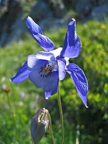 |
Gilgit-Baltistan is home to a number of diversified cultures, ethnic groups, languages and various backgrounds. It is home to people belonging to all regions of Gilgit-Baltistan as well as from other cities of Pakistan and aboard.[45] Cultural events include:[45]
- Navroz
- Jashn-e-Baharan
- Shandoor Polo Festival
- Babusar Polo Festival
- Harvest time festival.
These festivals are opportunity for local people and tourists to get together and share their skills.
Moreover, Gilgit-Baltistan is also famous for its dance. Following are the kinds of dances famous in tourists and local people of Gilgit-Baltistan:[45]
- Old Man Dance: In this dance more then one persons wear some old style dresses and dance.
- Cow Boy Dance (Payaloo): In this dance a person wears old style dress, long leather shoes and a stick in hand.
- Sword Dance: In this unique dance the participants show taking one sword in right and shield in left. One to six participants as pair can dance.
See also
References
- ↑ http://gbtribune.files.wordpress.com/2012/09/self-governance-order-2009.pdf
- ↑ "Pir Karam Ali Shah appointed GB Governor". The News. 2011-01-26. Retrieved 2011-01-28.
- ↑ "Public service policy to be pursued in Gilgit-Baltistan: PM". Ftp://app.com.pk. Retrieved 2010-06-05.
- ↑ Legislative Assembly will have directly elected 24 members, besides six women and three technocrats. "Gilgit Baltistan: New Pakistani Package or Governor Rule" 3 September 2009, The Unrepresented Nations and Peoples Organization (UNPO)
- ↑ "Cabinet approves ‘Gilgit-Baltistan Empowerment and Self-Governance Order 2009’" 29 August 2009 Associated Press of Pakistan
- ↑ 6.0 6.1 6.2 Weightman, Barbara A. (2 December 2005). Dragons and Tigers: A Geography of South, East, and Southeast Asia (2nd ed.). John Wiley & Sons. p. 193. ISBN 978-0-471-63084-5.
- ↑ 7.0 7.1 "Gilgit-Baltistan autonomy". Dawn. 2009-09-09. Retrieved 2013-02-23.
- ↑ "Ahmad Shah and the Durrani Empire". Library of Congress Country Studies on Afghanistan. 1997. Retrieved 2010-09-23.
- ↑ Friedrich Engels (1857). "Afghanistan". Andy Blunden. The New American Cyclopaedia, Vol. I. Archived from the original on 18 October 2010. Retrieved 2010-09-23.
Afghanistan … an extensive country of Asia...between Persia and the Indies, and in the other direction between the Hindu Kush and the Indian Ocean. It formerly included the Persian provinces of Khorassan and Kohistan, together with Herat, Beluchistan, Cashmere, and Sinde, and a considerable part of the Punjab... Its principal cities are Kabul, the capital, Ghuznee, Peshawer, and Kandahar
- ↑ "Aḥmad Shah Durrānī". Encyclopædia Britannica Online Version. 2010. Retrieved 2010-08-25.
- ↑ Clements, Frank (2003). Conflict in Afghanistan: a historical encyclopedia. ABC-CLIO. 81. ISBN 978-1-85109-402-8. Retrieved 2010-09-23.
- ↑ "The Durrani dynasty". Encyclopædia Britannica Online. Retrieved 2010-09-23.
- ↑ "Afghanistan 1809–1838: Sources in the India Office Records". Bl.uk. 2003-11-30. Retrieved 2013-02-23.
- ↑ Schofield, Victoria (2003). Kashmir in conflict: India, Pakistan and the unending war. I.B.Tauris. p. 297. ISBN 978-1-86064-898-4.
- ↑ http://www.qal.org.pk/E-lab-files/NEWEPAPER%20CLIPPIGN'S%20TOPICS/Kashmir/Gilgit%20has%20remained%20part%20of%20Kashmir,The%20Dawn,4-3-2006.doc
- ↑ Marin, Steve (2011). Alexander Mikaberidze, ed. Conflict and Conquest in the Islamic World: A Historical Encyclopedia, Volume 1. ABC-CLIO. p. 394. ISBN 978-1598843361.
- ↑ Bose, Tapan K. (2004). Raṇabīra Samāddāra, ed. Peace Studies: An Introduction To the Concept, Scope, and Themes. Sage. p. 324. ISBN 978-0761996606.
- ↑ Warikoo, Kulbhushan (2008). Himalayan Frontiers of India: Historical, Geo-Political and Strategic Perspectives (1st ed.). Routledge. p. 78. ISBN 978-0415468398.
- ↑ Chellaney, Brahma (2011). Water: Asia's New Battleground. Georgetown University Press. p. 249. ISBN 978-1589017719.
- ↑ China’s Interests in Shaksgam Valley
- ↑ 21.0 21.1 21.2 Schofield, Victoria (2000). Kashmir in Conflict: India, Pakistan, and the Unending War. I.B. Tauris. pp. 180–181.
- ↑ 22.0 22.1 "Gilgit-Baltistan: A question of autonomy". Indian Express. September 21, 2009. Retrieved 2013-02-23.
- ↑ Shigri, Manzar. "Pakistan's disputed Northern Areas go to polls". Reuters.com. Retrieved 2013-02-23.
- ↑ "Pakistani president signs Gilgit-Baltistan autonomy order _English_Xinhua". News.xinhuanet.com. 2009-09-07. Retrieved 2010-06-05.
- ↑ "Gilgit-Baltistan part of Jammu and Kashmir: India". Times of India (Press Trust of India). March 10, 2006.
- ↑ "Wrangling over new Astore district headquarters". Dawn Newspaper Internet Edition. Retrieved 2006-11-17.
- ↑ 27.0 27.1 "Statistical Booklet on Gilgit-Baltistan" (PDF). Government of Gilgit-Baltistan, 2014. Retrieved 2014-12-11.
- ↑ Weiss, Anita M. and Mughal, Muhammad Aurang Zeb. (2012). 'Pakistan'. Kotzé, Louis and Morse, Stephen (eds), The Berkshire Encyclopedia of Sustainability, Vol. 9. Great Barrington, MA: Berkshire, pp. 236-240.
- ↑ Mughal, Muhammad Aurang Zeb. (2013). 'Pamir Alpine Desert and Tundra'. Robert Warren Howarth(ed.), Biomes & Ecosystems. Ipswich, MA: Salem Press, pp. 12-14.
- ↑ "Rock Carvings and Inscriptions along the Karakorum Highway (Pakistan) –- a brief introduction".
- ↑ "Between gandhara and the silk roads".
- ↑ WWF Pakistan. "Climate of Gilgit-Baltistan (formerly Northern Areas)". WWF Pakistan. Retrieved 2009-06-11.
- ↑ Encyclopædia Britannica. "Baltistan (region, Northern Areas, Kashmir, Pakistan) – Britannica Online Encyclopedia". Britannica.com. Retrieved 2010-06-05.
- ↑ Encyclopædia Britannica. "Gilgit (Kashmir region, Indian subcontinent) – Britannica Online Encyclopedia". Britannica.com. Retrieved 2010-06-05.
- ↑ "Pakistan | Gilgit-Baltistan autonomy". Dawn.Com. 2009-09-09. Retrieved 2010-06-05.
- ↑ Hakeem, Irfan (February 23, 2012). "Kashmiri activists seek India's support to 'save' PoK from China's increasing strength". Daily Mail.
- ↑ Sports and games of the 18th and … – Google Books. Books.google.co.nz. Retrieved 2010-06-05.
- ↑ "Kashgar-Gilgit bus service planned". Dawn Newspaper Internet Edition. Retrieved 2006-11-17.
- ↑ "Population, poverty and environment" (PDF). Northern Areas Strategy for Sustainable Development. Retrieved 2006-11-17.
- ↑ "Pakistan's Fragile Foundations". Council on Foreign Relations. 2009-03-12.
- ↑ Katy, Gardner (1999). Leif O. Manger, ed. Muslim diversity: local Islam in global contexts. Routledge. p. 64. ISBN 978-0-7007-1104-8.
- ↑ Gilgit-Baltistan - 8 Languages, 10 Ethnic Groups, 6 Districts, 4 Religious sects - 24 National Assembly Seats
- ↑ "Sectarian conflict in Gilgit-Baltistan" (PDF). pildat. May 2011. Retrieved 24 June 2013.
- ↑ "Pakistan Shias killed in Gilgit sectarian attack". BBC. 4 April 2014. Retrieved 13 November 2012.
- ↑ 45.0 45.1 45.2 "Culture and Heritage of Gilgit". visitgilgitbaltistan.gov.pk. Gov.Pk. Retrieved 23 April 2015.
Further reading
- Pakistan Trekking Guide, by Isobel and Ben Shaw, 1993.
- Wang, S. (2004). "Of Rivers and Human Rights: the Northern Areas, Pakistan's Forgotten Colony in Jammu and Kashmir". International Journal on Minority and Group Rights 11: 187. doi:10.1163/1571811041631272.
harrrrrrrrrr
External links
- Official Website of the Gilgit-Baltistan Council
- Official Website of the Government of Gilgit-Baltistan
- Gilgit-Baltistan at DMOZ
![]() Gilgit-Baltistan travel guide from Wikivoyage
Gilgit-Baltistan travel guide from Wikivoyage
 |
|
| ||
| style="width:33% rowspan=3 | |
|
| ||
| ||||
| | ||||
| |
|
| ||||||||||||||||||||||||||||||||||||||||||||||||||||||||||||||||||||||||||||||||||||||
_Districts.svg.png)


| |||||||||||||||||||||
| ||||||||||||||||||||