Gibson Flats, Montana
| Gibson Flats, Montana | |
|---|---|
| Census-designated place | |
 Gibson Flats | |
| Coordinates: 47°28′10″N 111°14′45″W / 47.46944°N 111.24583°WCoordinates: 47°28′10″N 111°14′45″W / 47.46944°N 111.24583°W | |
| Country | United States |
| State | Montana |
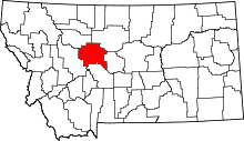
| County | Cascade |
| Area | |
| • Total | 3.01 sq mi (7.79 km2) |
| • Land | 3.01 sq mi (7.79 km2) |
| • Water | 0.0 sq mi (0.0 km2) |
| Elevation | 3,350 ft (1,020 m) |
| Population (2010) | |
| • Total | 199 |
| • Density | 66/sq mi (25.5/km2) |
| Time zone | Mountain (MST) (UTC-7) |
| • Summer (DST) | MDT (UTC-6) |
| Area code(s) | 406 |
| FIPS code | 30-30625 |
| GNIS feature ID | 0802107[1] |
Gibson Flats is a census-designated place (CDP) in Cascade County, Montana, United States. The population was 199 at the 2010 census.[2] It is part of the Great Falls, Montana Metropolitan Statistical Area.
Geography
Gibson Flats is located 3 miles (5 km) southeast of the center of Great Falls at 47°28′10″N 111°14′45″W / 47.46944°N 111.24583°W.[3]
According to the United States Census Bureau, the CDP has a total area of 3.0 square miles (7.8 km2), all of it land.[2]
References
- ↑ U.S. Geological Survey Geographic Names Information System: Gibson Flats, Montana
- ↑ 2.0 2.1 "Geographic Identifiers: 2010 Demographic Profile Data (G001): Gibson Flats CDP, Montana". U.S. Census Bureau, American Factfinder. Retrieved October 9, 2014.
- ↑ "US Gazetteer files: 2010, 2000, and 1990". United States Census Bureau. Retrieved October 9, 2014.
| ||||||||||||||||||||||||||||||||||||||||||||||||||||||||||||||||||||||||||
| |||||||||||||||||||||||||