Ggaba
| Ggaba | |
|---|---|
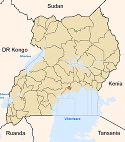
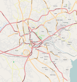 Ggaba Map of Kampala showing the location of Ggaba. | |
| Coordinates: 00°15′45″N 32°37′46″E / 0.26250°N 32.62944°E | |
| Country |
|
| Region | Central Uganda |
| District | Kampala Capital City Authority |
| Division | Makindye Division |
| Elevation | 1,140 m (3,740 ft) |
| Time zone | EAT (UTC+3) |
Ggaba is a section of the city of Kampala in central Uganda.
Location
Ggaba is located on the northern shores of Lake Victoria, at the southern tip of the city of Kampala. It is bordered by Murchison Bay in Lake Victoria to the south and east, the village of Kawuku to the northeast, Bbunga to the north, Buziga to the northwest and Munyonyo to the southwest. The coordinates of Ggaba are:0°15'45.0"N, 32°37'45.0"E (Latitude:0.262500; Longitude:32.629167). The road distance between Ggaba and the Kampala's central business district is approximately 11 kilometres (6.8 mi).[1][2]
Overview
Ggaba can be divided into the following major areas:
- The Lake Shore. This is the southeastern part of Ggaba and includes:
- A small beach
- A landing dock for fishing boats
- A fish market
- A shopping center
- A commercial resort with a private beach
- Several bars and night spots
- The Water Works. This is located in the southwestern part of the area and contains:
- The pumping stations (I, II and III) of National Water and Sewerage Corporation (NWSC). - The intake pumps that supply water to Kampala, Kira Municipality and Mukono are located here.
- The Main Water Treatment Plant of NWSC
- Houses for the blue-collar workers of NWSC
- Ggaba Police Station
- The Educational Area This is mainly located in the northern part of the area. The institutions include:
- The main campus of Kampala University
- Ggaba National Seminary (Catholic)
- Ggaba Teachers Training Institute
- St. Denis Ssebugwawo Secondary School
- The Bunga campus of St. Augustine International University
- Bbunga Primary School
- Bbunga Islamic School
- The residential Areas
- Interspersed between the schools, universities and teaching institutions are the residential areas. The areas in the southern and western Ggaba are generally of low income housing while those further north and east are upscale because they offer a better view of the lake.[3]
- The Medical Institutions
- Jacky Medical Centre - Located at the northern tip of Ggaba
- Wentz Medical Centre - Located in the northeastern part of Ggaba, close to Kampala University
- Martyrs Family Clinic - Located in the southern part of Ggaba, close to the NWSC Staff Houses
- Ggaba Community Health Centre - Located in the southern part of Ggaba, inside the low income residential area close to the NWSC Water Treatment Plant.[4]
See also
- St.Denis Ssebugwawo Secondary School
- Kampala
- Munyonyo
- Kabalagala
- Kansanga
- Makindye Division
- Kampala University
References
- ↑ "Distance Between Kampala And Ggaba With Map". Globefed.com. Retrieved 13 June 2014.
- ↑ "Know Your Hood: Ggaba; a fishing hub close to the city centre". http://www.monitor.co.ug/Magazines/HomesandProperty/Know-Your-Hood--Ggaba--a-fishing-hub-close-to-the-city-centre/-/689858/1997236/-/jv63jf/-/index.html''.
- ↑ Watuwa Timbiti, and Agnes Nantabi (30 April 2013). "Ggaba Suffocating Lake Victoria". New Vision. Retrieved 13 June 2014.
- ↑ Google, . "Location of Ggaba At Google Maps". Google Maps. Retrieved 13 June 2014.