Georgia State Route 82
| ||||
|---|---|---|---|---|
|
Georgia State Route 82 highlighted in red | ||||
| Route information | ||||
| Maintained by GDOT | ||||
| Length: | 36.2 mi[1] (58.3 km) | |||
| Major junctions | ||||
| South end: |
| |||
|
| ||||
| North end: |
| |||
| Location | ||||
| Counties: | Barrow, Jackson, Hall | |||
| Highway system | ||||
| ||||

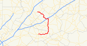
State Route 82 (SR 82) is an arc-shaped state highway in the northwest part of the U.S. state of Georgia. The highway runs 36.2 miles (58.3 km) from Winder to a point east of Gainesville.
Route description
Barrow County
SR 82 begins at an intersection with SR 11/SR 53/SR 211 in Winder. The route heads east from Winder to a second intersection with SR 211, northeast of Statham. Just east of that intersection, SR 82 intersects SR 330. A little ways to the northeast, the route enters Jackson County.
Jackson and Hall Counties
In the city of Arcade, SR 82 intersects US 129/SR 11 CONN. Just to the northeast, the route intersects US 129 BUS/SR 15 ALT. The three routes begin a concurrency northwest to Jefferson. In the city, the three routes intersect SR 11 BUS. SR 11 BUS joins the concurrency for just two blocks. At this intersection, US 129 BUS/SR 11 BUS depart to the northwest, while SR 15 ALT/SR 82 travel to the northeast. Just before leaving the city, the two routes split, with SR 82 heading to the north. Northwest of Jackson County Airport, the route intersects SR 82 CONN. Farther to the northwest, Interstate 85 (I-85) crosses the path.
Northwest of the interchange with I-85, the route enters Hall County, where it meets its northern terminus at SR 323 east of Gainesville, near Tadmore Elementary School.
Major intersections
| County | Location | mi[1] | km | Destinations | Notes |
|---|---|---|---|---|---|
| Barrow | Winder | 0.0 | 0.0 | Southern terminus | |
| 7.7 | 12.4 | ||||
| 8.4 | 13.5 | ||||
| Jackson | Arcade | 13.6 | 21.9 | ||
| 14.0 | 22.5 | Southern end of US 129 BUS/SR 15 ALT concurrency | |||
| Jefferson | 16.8 | 27.0 | Southern end of SR 11 BUS concurrency | ||
| 16.9 | 27.2 | Northern end of US 129 BUS & SR 11 BUS concurrencies | |||
| 17.2 | 27.7 | ||||
| 17.5 | 28.2 | Northern end of SR 15 ALT concurrency | |||
| 22.2 | 35.7 | ||||
| 24.1 | 38.8 | ||||
| Hall | 36.2 | 58.3 | Northern terminus | ||
1.000 mi = 1.609 km; 1.000 km = 0.621 mi
| |||||
Bannered route
| |
|---|---|
| Location: | Rural Jackson County-Maysville |
| Length: | 4.7 mi[2] (7.6 km) |
State Route 82 Connector (SR 82 Connector) is a 4.7-mile-long (7.6 km) connector route that begins at an intersection with the SR 82 mainline, north of Jefferson. It heads northeast, and then north, until it crosses, but without intersecting, Interstate 85 (I-85) approximately 2 miles (3.2 km) later. The route continues north until it meets its northern terminus, an intersection with SR 98 in Maysville.
See also
- Georgia (U.S. state) portal
- U.S. Roads portal
References
- ↑ 1.0 1.1 Google (October 17, 2012). "Route of SR 82" (Map). Google Maps. Google. Retrieved October 17, 2012.
- ↑ Google (October 17, 2012). "Route of SR 82 Connector" (Map). Google Maps. Google. Retrieved October 17, 2012.
External links
![]() Media related to Georgia State Route 82 at Wikimedia Commons
Media related to Georgia State Route 82 at Wikimedia Commons