Georgia State Route 234
| ||||
|---|---|---|---|---|
 | ||||
| Route information | ||||
| Maintained by GDOT | ||||
| Length: | 28.3 mi[1] (45.5 km) | |||
| Existed: | 1946[2][3] – present | |||
| Major junctions | ||||
| West end: |
| |||
|
| ||||
| East end: |
| |||
| Location | ||||
| Counties: | Calhoun, Dougherty | |||
| Highway system | ||||
| ||||
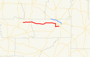
State Route 234 (SR 234) is a west-east state highway located in the southwestern part of the U.S. state of Georgia. It runs for approximately 28.3 miles (45.5 km) through portions of Calhoun and Dougherty counties.
Route description
SR 234 begins at an intersection with SR 45 northeast of Morgan in Calhoun County. The route runs east, passing Calhoun County Road 45 (Lizard Lope Road, which leads to Conley Cemetery), Calhoun CR 136 (Wildemeade Road), and Calhoun CR 119, before it reaches an intersection with SR 55, northeast of Leary. Shortly after SR 55, the route crosses into Dougherty County. Farther to the east, SR 234 intersects Tallahassee Road, which leads to Sasser. Just before entering Albany, the road passes Live Oak Elementary School. In downtown Albany, it passes Darton State College. Farther in, it has a very brief concurrency with US 19 Business/US 82 Business/SR 520 Business. Then, it passes Albany Technical College just before intersections with SR 62 (Slappey Boulevard) and SR 91 (Newton Road). SR 91 leads to Southwest Georgia Regional Airport. Just before ending, it crosses over the Flint River. On the eastern edge of Albany it meets its eastern terminus, an interchange with US 19/SR 3/SR 133/SR 300. Here, US 19/SR 3/SR 300, as well as SR 133 north, are known as Liberty Expressway, while SR 133 south continues the roadway of SR 234 along Moultrie Road.[1]
No section of SR 234 is part of the National Highway System, a system of routes determined to be the most important for the nation's economy, mobility and defense.[4]
History
SR 234 was established, and paved, in 1946 along the same alignment as it runs today.[2][3]
Major intersections
| County | Location | mi[1] | km | Destinations | Notes |
|---|---|---|---|---|---|
| Calhoun | 0.0 | 0.0 | Western terminus | ||
| 4.3 | 6.9 | ||||
| Dougherty | Albany | 22.6 | 36.4 | Western end of US 19 Business/US 82 Business/SR 520 Business concurrency | |
| 22.9 | 36.9 | Eastern end of US 19 Business/US 82 Business/SR 520 Business concurrency | |||
| 24.7 | 39.8 | Eastern terminus of SR 62 | |||
| 24.8 | 39.9 | ||||
| 28.3 | 45.5 | Eastern terminus; US 19 north/SR 3 north/SR 133 north/SR 300 north, as well as US 19 south/SR 3 south/SR 300 south run along Liberty Expressway; SR 133 south runs along Moultrie Road. | |||
1.000 mi = 1.609 km; 1.000 km = 0.621 mi
| |||||
See also
- Georgia (U.S. state) portal
- U.S. Roads portal
References
- ↑ 1.0 1.1 1.2 Google (February 27, 2013). "Route of SR 234" (Map). Google Maps. Google. Retrieved February 27, 2013.
- ↑ 2.0 2.1 Georgia State Highway System (PDF) (Map). Cartography by GSHD. Georgia State Highway Department. January 1, 1945. Retrieved February 28, 2013.
- ↑ 3.0 3.1 Georgia State Highway System (PDF) (Map). Cartography by GSHD. Georgia State Highway Department. November 7, 1946. Retrieved February 28, 2013.
- ↑ "National Highway System: Georgia" (PDF). United States Department of Transportation. May 8, 2009. Retrieved February 28, 2013.
External links
-
 Media related to Georgia State Route 234 at Wikimedia Commons
