Georgia State Route 151
| ||||
|---|---|---|---|---|
 | ||||
| Route information | ||||
| Maintained by GDOT | ||||
| Length: | 31.5 mi[1] (50.7 km) | |||
| Major junctions | ||||
| South end: |
| |||
|
| ||||
| North end: |
| |||
| Location | ||||
| Counties: | Walker, Catoosa | |||
| Highway system | ||||
| ||||

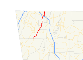
State Route 151 (SR 151) is a 31.5-mile-long (50.7 km) state highway that runs southwest-to-northeast through portions of Walker and Catoosa counties in the northwestern part of the U.S. state of Georgia. The route connects the LaFayette area with the southeastern part of the Chattanooga, Tennessee area.
Route description
SR 151 begins at an intersection with US 27/SR 1, south of LaFayette, in the southern part of Walker County, just north of the Chattooga County line. The road heads northeast to the Unincorporated community of Naomi, where it intersects SR 136. The two highways have a short concurrency. After the concurrency ends, SR 151 continues to the northeast and enters Catoosa County. In Ringgold, SR 151 has an interchange with Interstate 75 (I-75). Almost immediately afterward is a brief concurrency with US 41/US 76/SR 2/SR 3. SR 151 departs to the north and continues until it meets its northern terminus, the Tennessee state line, where the roadway continues as Tennessee State Route 321.[1]
SR 151 is not part of the National Highway System, a system of roadways important to the nation's economy, defense, and mobility.[2]
Major intersections
| County | Location | mi[1] | km | Destinations | Notes |
|---|---|---|---|---|---|
| Walker | 0.0 | 0.0 | Southern terminus | ||
| Chattahoochee-Oconee National Forest | 8.6 | 13.8 | Southern end of SR 136 concurrency | ||
| 10.1 | 16.3 | Northern end of SR 136 concurrency | |||
| 11.9 | 19.2 | Southern terminus of SR 95 | |||
| Catoosa | Ringgold | 25.0 | 40.2 | I-75, exit 348 | |
| 25.6 | 41.2 | Southern end of US 41/US 76/SR 2/SR 3 concurrency | |||
| 26.4 | 42.5 | Northern end of US 41/US 76/SR 2/SR 3 concurrency | |||
| Tennessee state line | 31.5 | 50.7 | Northern terminus; roadway continues as SR 321. | ||
1.000 mi = 1.609 km; 1.000 km = 0.621 mi
| |||||
See also
- Georgia (U.S. state) portal
- U.S. Roads portal
References
- ↑ 1.0 1.1 1.2 Google (June 27, 2013). "Route of SR 151" (Map). Google Maps. Google. Retrieved June 27, 2013.
- ↑ "National Highway System: Georgia" (PDF). United States Department of Transportation. October 1, 2012. Retrieved June 27, 2013.
External links
-
 Media related to Georgia State Route 151 at Wikimedia Commons
 - Georgia Roads (Routes 141 - 160)