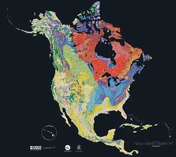
Geology of the United States
The geology of the United States is a subset of the regional geology of North America.

The United States is considered in this article as defined by its political boundaries, although geographical study is often focused towards classifying areas according to a shared geography.
Canadian shield

The Canadian Shield is the stable interior of the North American continent,[1] and it is well-exposed in the United States in the Great Lakes region, where deeply eroded rocks have been exhumed by the process of glaciation. The exposures include a variety of rocks, largely metamorphosed. igneous and sedimentary rocks.
Stable platform
A large part of the center of the lower 48 states consists of the stable (or continental) platform. Here, the Precambrian rocks of the Shield are buried beneath Phanerozoic sedimentary strata, left behind by glacial movement. Tectonic activity is minor, with occasional broad domes and basins that reveal mild epeirogenic deformation.
Appalachian orogenic belt
The Appalachian orogenic pants extends from New England south into Mississippi and Alabama. The Ouachita Mountains of Arkansas, and even the Marathon Uplift of Texas are also part of the same province, having all formed in the Alleghenian orogeny that took place when Pangea assembled during the late Paleozoic. Once lofty, they have been heavily weathered since the opening of the Atlantic Ocean. The Appalachians proper consist of deformed sedimentary rocks, cut through by numerous thrust faults; as in the western cordillera, the Appalachians experienced several orogenies over the course of the Paleozoic, making their geologic history difficult to interpret.
Passive Margin
The United States has passive, or inactive, continental margins along the Atlantic Coast and the Gulf of Mexico.[2]
The coastal plain extends from the southern tip of Texas across the northern Gulf of Mexico and into the Mississippi embayment, and northeast through the Mid-Atlantic states. A classic passive continental margin, it consists of a deep clastic wedge of sediment eroded from the platform and mountain belts; it first formed during the opening of the Atlantic Ocean and Gulf of Mexico during the Jurassic and Cretaceous periods.
The passive margin of the Gulf of Mexico is a series of sediments deposits from upland areas surrounding the margin. The environment of deposition for these sediments has changed, varying spatially and temporally. When the ocean level was high shallow marine deposits occurred; when they were low fluvial and deltaic deposits form the majority of mass.[3] From the Triassic until the early Jurassic, faulting localized as extension faulting and wrench faulting. As the basement subsided, sediment accumulated, during the Mesozoic and Cenozoic, forming the modern wedge, containing salt basins.[4]
American cordillera

The American cordillera is part of a great length of mountain ranges that extend along the western edge of the continent; in the United States these mountain ranges extend roughly from the Great Plains westward to the Pacific Ocean. The ranges include the Pacific Coast Ranges, the Cascades, the Sierra Nevada, and the mountain chains of the Basin and Range province; the Rocky Mountains are sometimes excluded from the cordillera proper.
The geology of this region is complex, having gone through numerous times of building mountains and deforming the existing ones, faulting, volcanic activity, and periods of uplift separated by intervals of erosion. Much of the cordillera consists of terranes, ancient microcontinents and island arcs that were welded onto the North American craton during the Paleozoic and Mesozoic eras. The geological history of the cordillera is typical of convergent plate boundaries, as has characterized the cordillera through most of the Phanerozoic.
Hawaii
The Hawaiian Islands are part of a chain of islands, the Hawaiian–Emperor seamount chain, formed on the Pacific Plate as it passes over a mantle plume.
Puerto Rico and Guam
Puerto Rico is an island formed at the active margin between the Caribbean Plate and the North American Plate. Guam is part of an island arc system, the Mariana Islands.
See also
References
- ↑ Chu, Risheng; Schmandt, Brandon; Helmberger, Don V. (1 February 2012). "Upper mantle P velocity structure beneath the Midwestern United States derived from triplicated waveforms". Geochemistry, Geophysics, Geosystems 13 (2): n/a–n/a. doi:10.1029/2011GC003818.
- ↑ Huerta, AD; DL Harry (March 2012). "Wilson cycles, tectonic inheritance, and rifting of the North American Gulf of Mexico continental margin". Geosphere 8 (2). doi:10.1130/GES00725.1.
- ↑ Grubb, Hayes; Carillo, J. Joel. (1988). "Chapter 26: Region 23, Gulf of Mexico Coastal Plain". In Back, William; Rosenshein, Joseph; Seaber, Paul. The Geology of North America. The Geological Society of America. pp. 219–228. Retrieved 28 Feb 2013.
- ↑ Mancini, Ernest; Obid, Jamal; Badali, Marcello; Liu, Kaiyu; Parcell, William (December 2008). "Sequence-stratigraphic analysis of Jurassic and Cretaceous strata and petroleum exploration in the central and eastern Gulf coastal plain, United States". AAPG Bulletin 92 (12): 1655–1686. doi:10.1306/08130808046. Retrieved 28 Feb 2013.
- Marshak, Stephen. (2001) Earth: Portrait of a Planet, New York: W.W. Norton & Company, ISBN 0-393-97423-5. pp. 339–44, 401-2.
External links
| ||||||||||||||