Geography of Wales
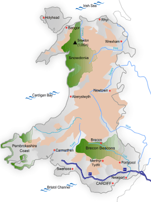
Wales (Welsh: Cymru) is a generally mountainous country which is part of the United Kingdom. It is situated on the western side of central southern Great Britain, between the Irish Sea to the north and the Bristol Channel to the south. It is bordered by England to its east and the Atlantic Ocean, St George's Channel and Irish Sea to its west. It is about 274 km (170 mi) from north to south and at least 97 km (60 mi) wide, with a total area of 20,779 km2 (8,023 sq mi). It has over 1,200 km (746 mi) of coastline, and includes offshore islands, of which the largest is Anglesey.
Cardiff is the capital of Wales and its largest city. It is situated in the highly urbanised area of South East Wales; its metropolitan area has a population of 1,097,000, which includes the city of Newport to the east. Wales' second-largest city of Swansea, also in South Wales, is further west.
Topography and geology
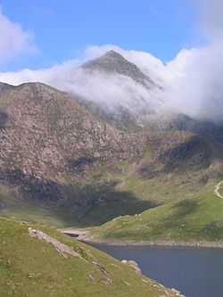
Much of Wales is mountainous, particularly three main regions: Snowdonia in the north west, the Cambrian Mountains in mid Wales, and the Brecon Beacons in the south. The mountains largely assumed their present shape during the last ice age, the Devensian glaciation. Snowdonia contains the highest peaks, topped by Snowdon (Welsh: Yr Wyddfa) at 1,085 m (3,560 ft). The 14 (or possibly 15) peaks over 3,000 feet (914 m) are known collectively as the Welsh 3000s.
In the mid 19th century, two prominent geologists, Roderick Murchison and Adam Sedgwick used their studies of the geology of Wales to establish certain principles of stratigraphy and palaeontology. The classical name for Wales, Cambria (derived from Cymru), gave its name to the earliest geological period of the Paleozoic era, the Cambrian. After much dispute, the next two periods of the Paleozoic era, the Ordovician and Silurian, were named after pre-Roman Celtic tribes from Wales, the Ordovices and Silures.
Land use
The land area of Wales is 2,064,100 hectares. Crops and fallow land account for 3 per cent of the land area, grasses and rough grazing 73 per cent, other agricultural land 1 per cent, forest and woodland 13 per cent, and urban development 10 per cent.[1]
Political geography
Border between Wales and England
The modern border between Wales and England was largely defined by the Laws in Wales Acts 1535–1542, based on the boundaries of medieval Marcher lordships. It has never been confirmed by referendum or reviewed by a Boundary Commission. The boundary line very roughly follows Offa's Dyke from south to north as far as a point about 40 miles (64 km) from the northern coast, but then swings further east. It has a number of anomalies - for instance, it separates Knighton from its railway station, virtually cuts off Church Stoke from the rest of Wales, and divides the village of Llanymynech where a pub straddles the line.
Local Government
Wales is divided into 22 unitary authorities, which are responsible for the provision of all local government services, including education, social work, environmental and roads services. Below these in some areas there are community councils, which cover specific areas within a council area. The unitary authority areas are known as principal areas. The Queen appoints a Lord Lieutenant to represent her in the eight Preserved counties of Wales.
In the Office for National Statistics Area Classification, local authorities are clustered into groups based in the six main census dimensions (demographic, household composition, housing, socio-economic, employment and industry sector). Most of the local authorities in mid and west Wales are classified as part of the 'Coastal and Countryside' supergroup. Most of the south Wales authorities, Flintshire and Wrexham are in the 'Mining and Manufacturing' supergroup; Cardiff is part of the 'Cities and Services' supergroup and the Vale of Glamorgan is part of 'Prospering UK'.[2]
Settlements
The main population and industrial areas in Wales are in South Wales, specifically Cardiff, Swansea and Newport, and the adjoining South Wales Valleys. In addition to these three principal cities, there are three other cities in Wales – St David's, Bangor and St Asaph.
A large share of the Welsh population lives in smaller settlements: nearly 20% live in villages of less than 1,500 persons compared with 10% in England. Wales also has a relatively low share of its population in large settlements: only 26% live in urban areas with a population over 100,000; in comparison, nearly 40% of the English population live in urban areas larger than the largest in Wales. Another feature of the settlement pattern in Wales is the share of the population living in the sparsest rural areas – 15% – compared with only 1.5% in England.[3]
- See also: The list of towns in Wales.
Traditional landmarks
The Seven Wonders of Wales is a traditional list of seven geographic and cultural landmarks in Wales: Snowdon, the Gresford bells (the peal of bells in the medieval church of All Saints at Gresford), the Llangollen bridge (built in 1347 over the River Dee), St Winefride's Well (a pilgrimage site at Holywell in Flintshire) the Wrexham steeple (16th-century tower of St. Giles Church in Wrexham), the Overton yew trees (ancient yew trees in the churchyard of St Mary's at Overton-on-Dee) and Pistyll Rhaeadr (at 240 ft or 73 m waterfall). The "wonders" are part of the traditional rhyme:
- Pistyll Rhaeadr and Wrexham steeple,
- Snowdon's mountain without its people,
- Overton yew trees, St Winefride wells,
- Llangollen bridge and Gresford bells.
Climate
- Highest maximum temperature: 34.2 °C (93.6 °F) at Hawarden Bridge, Flintshire on 2 August 1990.
- Lowest minimum temperature: −23.3 °C (−9.9 °F) at Rhayader, Radnorshire on 1 January 1940.
- Bright sunshine: Maximum duration in a month: 354.3 hours at Dale Fort, Pembrokeshire in July 1955; minimum duration in a month: 2.7 hours at Llwynon, Brecknockshire in January 1962.
- Rainfall: Maximum in a day (09-09 UTC): 211 mm (8.3 in) at Rhondda, Glamorgan on 11 November 1929.
- Wind: Highest gust recorded at a low-level site: 108 knots (124 mph; 200 km/h) at Rhoose, South Glamorgan on 28 October 1989.[4]
On average, Wales is cloudier than England, because of the hilly nature of the terrain and the proximity to the Atlantic. Rainfall in Wales varies widely, with the highest average annual totals in Snowdonia and the Brecon Beacons, and the lowest in the east, close to the English border. Throughout Wales, the months from October to January are significantly wetter than those between February and September. Snow is comparatively rare near sea level in Wales, but much more frequent over the hills. The average number of days each year when sleet or snow falls in Wales varies from about 10 or less in some south-western coastal areas to over 40 in Snowdonia.[4]
National Parks
Wales has three designated national parks:
- Brecon Beacons National Park, in the southeast of Wales
- Pembrokeshire Coast National Park, including the Pembrokeshire coast, Preseli Hills and Daugleddau
- Snowdonia National Park in the Snowdonia region of northwest Wales
Areas of Outstanding Natural Beauty
- Gower Peninsula – the first area in Britain to be designated an Area of Outstanding Natural Beauty in 1956.
- Anglesey
- Clwydian Range and Dee Valley
- Llŷn Peninsula
- Wye Valley (partly in England)
Waterfalls
Wales has many waterfalls, including some of the most striking in the United Kingdom. One such is the 240 ft (73.2 m) Pistyll Rhaeadr near the village of Llanrhaeadr-ym-Mochnant and meaning "spring of the waterfall" in Welsh. It is formed as the Afon Disgynfa drops over a Silurian cliff and continues below as the Afon Rhaeadr. The falls are counted as one of the Seven Wonders of Wales and the site is designated as the 1000th Site of Special Scientific Interest by the Countryside Council for Wales, for its importance to Welsh geomorphology. The 19th-century English author George Borrow remarked of the waterfall, "I never saw water falling so gracefully, so much like thin, beautiful threads, as here."
Other notable waterfalls include, in North Wales, Aber Falls (Welsh: Rhaeadr Fawr, "great waterfall") at Abergwyngregyn and the Rhaeadr Cynfal falls in Ffestiniog (including Rhaeadr y Cwm). In mid Wales, Pistyll Blaen-y-Cwm in the upper Tanat Valley and those at Devil's Bridge draw tourists. In the south are Sgwd Henrhyd near Coelbren, Melincourt Falls near Resolven and several in a small area known as Waterfall Country in the south of the Brecon Beacons National Park.
Lakes and Reservoirs
See also List of lakes in Wales
.jpg)
The largest natural lake in Wales is Llyn Tegid (Bala Lake).
Wales contains many man-made reservoirs, some of which are popular resorts for outdoor activities such as sailing and fishing. The largest are in the Elan Valley, including the Claerwen. Others notable reservoirs include Lake Vyrnwy, Talybont Reservoir, and Llyn Brianne.
See also
- Geology of Wales
- List of Blue Flag Beaches of Wales
- Geography of the United Kingdom
- Geography of England
- Geography of Scotland
- Geography of Ireland
Notes
- ↑ National Statistics (2004). UK 2005. The Official Yearbook of the United Kingdom of Great Britain and Northern Ireland. London: The Stationery Office. p. 279. ISBN 0-11-621738-3.
- ↑ "NS 2001 Area Classification for Local Authorities". Retrieved 20 December 2009.
- ↑ Welsh Assembly Government (December 2005). Rural Development Plan for Wales, 2007 – 2013. The Strategic Approach. pp. 61–63. ISBN 0-7504-9757-2.
- ↑ 4.0 4.1 Met Office: Welsh climate
| ||||||||||||||||||||||||||||||||||||||||||||||||||||
| ||||||||||||||||||