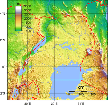
Geography of Uganda


Uganda is located in Eastern Africa, west of Kenya, south of South Sudan and east of the Democratic Republic of the Congo. It is in the heart of the Great Lakes region, and is surrounded by three of them, Lake Edward, Lake Albert, and Lake Victoria. While much of its border is lakeshore, Uganda is landlocked with no access to the sea.
Despite being on the equator Uganda is more temperate than the surrounding areas due to its altitude. The country is mostly plateau with a rim of mountains. This has made it more suitable to agriculture and less prone to tropical diseases than other nations in the region.
The climate is tropical; generally rainy with two dry seasons (December to February, June to August). It is semiarid East Sudanian savanna in north near Sudan.
Geographic coordinates: 1°00′N 32°00′E / 1.000°N 32.000°E
Climate
Uganda's climate is tropical. This means it is generally rainy (particularly during the months of March to May, September to November), while the remaining months (December to February, June to August) comprise Uganda's two dry seasons.
Statistics

Area:
total:
241 038 km²
land:197 100 km²
water:
43 938 km²
Land boundaries:
total:
2 698 km
border countries:
Democratic Republic of the Congo 765 km, Kenya 933 km, Rwanda 169 km, South Sudan 435 km, Tanzania 396 km
Elevation extremes:
lowest point:
Lake Albert 621 m
highest point:
Margherita Peak on Mount Stanley 5,110m
Natural resources: copper, cobalt, hydropower, limestone, salt, arable land, gold
Land use:
arable land:
27.94%
permanent crops:
9.11%
other:
62.95% (2011)
Irrigated land: 144.2 km² (2010)
Total renewable water resources: 66 km2 (2011)
Environment - current issues: draining of wetlands for agricultural use; deforestation; overgrazing; soil erosion; water hyacinth infestation in Lake Victoria; widespread poaching
Environment - international agreements:
party to:
Biodiversity, Climate Change, Climate Change-Kyoto Protocol, Desertification, Endangered Species, Hazardous Wastes, Law of the Sea, Marine Life Conservation, Ozone Layer Protection, Wetlands
signed, but not ratified:
Environmental Modification
Geography - note: Uganda is one of 6 African states that lies on the equator. Most of Uganda is north of the equator.
Extreme points
This is a list of the extreme points of Uganda, the points that are farther north, south, east or west than any other location.
- Northernmost point - the tripoint with Kenya and Sudan, Kotido District
- Easternmost point - unnamed location on the border with Kenya, Nakapiripirit District
- Southernmost point - unnamed location on the border with Rwanda immediately south of Lake Bunyonyi, Kabale District
- Westernmost point - unnamed location on the border with the Democratic Republic of the Congo immediately east of the Congolese village of Kirambo, Kisoro District
See also
- List of national parks of Uganda
References
| |||||||||||||||||||||||||||||||||||||||||
| ||||||||||||||
| ||||||||||||||