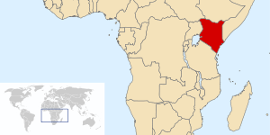
Geography of Kenya

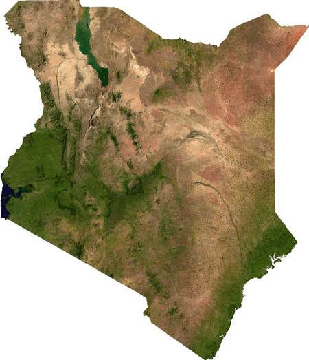
The geography of Kenya is diverse. Kenya has a coastline on the Indian Ocean, which contains swamps of East African mangroves. Inland are broad plains and numerous hills.
Central and Western Kenya is characterised by the Kenyan Rift Valley home to two of Africa's highest mountains, Mount Kenya and Mount Elgon.The Kakamega Forest in western Kenya is relic of an East African rainforest. Much larger is Mau Forest, the largest forest complex in East Africa.
Geography
Location
- Eastern Africa on the Indian Ocean coast between Somalia and Tanzania
- Geographic coordinates: 1°00′N 38°00′E / 1.000°N 38.000°E
Area
- Total: 580,367 km2 (224,081 sq mi)
- Land: 569,140 km2 (219,750 sq mi)
- Water: 11,227 km2 (4,335 sq mi)
Land boundaries
- Total: 3,477 km (2,161 mi)
- Border countries: Ethiopia 861 km (535 mi), Somalia 682 km (424 mi), South Sudan 232 km (144 mi), Tanzania 769 km (478 mi), Uganda 933 km (580 mi)[1]
Coastline
- 536 km (333 mi) along the Indian Ocean.
Maritime claims
- Continental shelf: 200 m depth or to the depth of exploitation
- Exclusive economic zone: 200 nmi (370.4 km; 230.2 mi)
- Territorial sea: 12 nmi (22.2 km; 13.8 mi)
Geology
Much of the western two-thirds of the country consists of the Pliocene–Pleistocene volcanics deposited on Precambrian basement rocks.[2] The southeast corner of the country is underlain by sediments of the Karoo System of Permian to Late Triassic age and a strip of Jurassic age sediments along the coast in the Mombasa area.[2] The Anza trough is a NW–SE trending Jurassic rift extending from the Indian Ocean coast to the Sudan northwest of Lake Turkana. The Anza Rift resulted from the break–up of Gondwana.[2][3]
Climate
The climate of Kenya varies by location, from mostly cool every day, to always warm/hot.[4][5][6] The climate along the coast is tropical. This means rainfall and temperatures are higher throughout the year. At the coastal cities, Mombasa, Lamu and Malindi, the air changes from cool to hot, almost every day (see chart below).[6]
The further inside Kenya, the more arid the climate becomes. An arid climate is nearly devoid of rainfall, and temperature swings widely according to the general time of the day/night. For many areas of Kenya, the daytime temperature rises about 12 C (corresponding to a rise of about 22F), almost every day.[4][5][6]
Elevation is the major factor in temperature levels, with the higher areas, on average, as 11 °C (20 °F) cooler, day or night.[4][5][6] The many mile-high cities have temperature swings from roughly 50–79 °F (10.0–26.1 °C). Nairobi, at 1,798 m (5,899 ft) or 1.798 km (1.12 mi), ranges from 49–80 °F (9.4–26.7 °C),[4] and Kitale, at 1,825 m (5,988 ft) or 1.825 km (1.13 mi), ranges from 51–82 °F (10.6–27.8 °C).[5] At night, heavy clothes or blankets are needed, in the highlands, when the temperature drops to about 50–54 °F (10.0–12.2 °C) every night.
At lower altitudes, the increased temperature is like day and night, literally: like starting the morning at the highland daytime high, and then adding the heat of the day, again. Hence, the overnight low temperatures near sealevel are nearly the same as the high temperatures of the elevated Kenyan highlands. However, locations along the Indian Ocean have more moderate temperatures, as a few degrees cooler in the daytime, such as at Mombasa (see chart below).
There are slight seasonal variations in temperature, of 4 °C or 7.2 °F,[4][5][6] cooler in the winter months. Although Kenya is centred at the equator, it shares the seasons of the southern hemisphere: with the warmest summer months in February–March and the coolest winter months in July–August, although only a few degrees cooler.[4][5][6]
On the high mountains, such as Mount Kenya, Mount Elgon and Kilimanjaro, the weather can become bitterly cold for most of the year. Some snowfall has occurred on the highest mountains.
| Climate Data for Mombasa (at Indian Ocean)[6] | |||||||||||||||
|---|---|---|---|---|---|---|---|---|---|---|---|---|---|---|---|
| NOAA Code | Statistic | Jan | Feb | Mar | Apr | May | Jun | Jul | Aug | Sep | Oct | Nov | Dec | Avg | |
| 0101 | Temperature Average F | 81.7 | 82.6 | 82.9 | 81.7 | 79.2 | 76.6 | 75.2 | 75.2 | 76.5 | 78.3 | 80.4 | 81.3 | 79.3 | |
| 0201 | Temperature High value F | 91.8 | 92.7 | 92.7 | 90.5 | 87.6 | 84.9 | 83.7 | 83.8 | 85.5 | 86.9 | 88.9 | 91 | 88.3 | |
| 0301 | Temperature Low value F | 71.6 | 72.5 | 73.2 | 72.9 | 70.9 | 68.2 | 66.7 | 66.7 | 67.5 | 69.6 | 71.8 | 71.6 | 70.3 | |
| 0615 | Precipitation in inches[6] | 1.4 | 0.6 | 2.3 | 6.3 | 9.7 | 3.6 | 2.9 | 2.8 | 2.8 | 4.2 | 4.3 | 3.1 | 3.7 | |
| 0101 | Temperature Average C | 27.6 | 28.1 | 28.3 | 27.6 | 26.2 | 24.8 | 24.0 | 24.0 | 24.7 | 25.7 | 26.9 | 27.4 | 26.27 | |
| 0201 | Temperature High value C | 33.2 | 33.7 | 33.7 | 32.5 | 30.9 | 29.4 | 28.7 | 28.8 | 29.7 | 30.5 | 31.6 | 32.8 | 31.29 | |
| 0301 | Temperature Low value C | 22.0 | 22.5 | 22.9 | 22.7 | 21.6 | 20.1 | 19.3 | 19.3 | 19.7 | 20.9 | 22.1 | 22.0 | 21.26 | |
| 0615 | Precipitation in mm[6] | 33.9 | 14.0 | 55.6 | 154.3 | 246 | 88.3 | 71.8 | 68.2 | 67.2 | 103.4 | 104.7 | 75.8 | 89.39 | |
| 1109 | Humidity Maximum % | 76.0 | 76.0 | 78.0 | 82.0 | 85.0 | 84.0 | 86.0 | 85.0 | 82.0 | 81.0 | 80.0 | 78.0 | 81.08 | |
| 1110 | Humidity[6] Minimum % | 62.0 | 59.0 | 61.0 | 66.0 | 70.0 | 67.0 | 67.0 | 66.0 | 65.0 | 66.0 | 68.0 | 65.0 | 65.17 | |
Terrain

Kenya's terrain is composed of low plains that rise into central highlands that are, in turn, bisected by the Great Rift Valley. There is also a fertile plateau in the west of the country.
Elevation extremes
The lowest point on Kenya is at sea level on the Indian Ocean. The highest point on Kenya is 5,199 meters above sea level at Mount Kenya.
Rivers
The two main rivers are the Galana and the Tana. However, the Ewaso Ng'iro is an important river, supplying water from Mt. Kenya to the eastern and north-eastern part of Kenya.
Natural resources
Natural resources that are found on Kenya include: limestone, soda ash, salt, gemstones, fluorspar, zinc, diatomite, oil, gas, gypsum, wildlife and hydropower.
Land use
9.48% of the land is arable. Permanent crops occupy 1.12% of the land. Other uses make up the rest of Kenya's land. (2011)
Irrigated land
1032 km² of Kenya' land is irrigated.(2003)
Total renewable water resources
30.7 km3 (2011)
Natural hazards
Natural hazards include recurring drought and flooding during the rainy seasons.
There is limited volcanic activity in the country. The Barrier (elev. 1,032 m) last erupted in 1921. South Island is the only other historically active volcano.
Environmental issues
Current issues
Current issues that threaten the environment at the moment include water pollution from urban and industrial wastes; degradation of water quality from the increased use of pesticides and fertilizers; deforestation; water hyacinth infestation in Lake Victoria; soil erosion; desertification; and poaching.
International agreements
- Party to: Biodiversity, Climate Change, Climate Change-Kyoto Protocol, Desertification, Endangered Species, Hazardous Wastes, Law of the Sea, Marine Dumping, Marine Life Conservation, Ozone Layer Protection, Ship Pollution (MARPOL 73/78), Wetlands, Whaling
- Signed, but not ratified: none of the selected agreements
Extreme points
This is a list of the extreme points of Kenya, the points that are farther north, south, east or west than any other location.
- Northernmost point – Kalukwakerith mountain, Rift Valley Province*
- Easternmost point – the tripoint with Ethiopia and Somalia, North Eastern Province
- Southernmost point – the point where the border with Tanzania enters the Indian Ocean, Coast Province
- Westernmost point – unnamed headland immediately east of Port Victoria, Nyanza Province
- Note: This is including the disputed Ilemi Triangle region. If this area is excluded then Kenya does not have a northernmost point, the northern border being a straight line
See also
References
- ↑ cia.gov – The World Factbook Kenya
- ↑ 2.0 2.1 2.2 Petroleum Potential of NW-Kenya Rift Basins: A Synopsis of Evidence and Issues
- ↑ L C Greene, D R Richards, R A Johnson (1991). "Crustal structure and tectonic evolution of the Anza rift, northern Kenya". Tectonophysics 197 (2–4): 203–211. doi:10.1016/0040-1951(91)90041-P. Retrieved 2011-11-20.
- ↑ 4.0 4.1 4.2 4.3 4.4 4.5 "NairobiDagoretti, Kenya: Climate, Global Warming, and Daylight Charts and Data", Climate-Charts.com, 2008, web: CC741: compare Nairobi/Dagoretti data with the Kitale or Mombasa charts.
- ↑ 5.0 5.1 5.2 5.3 5.4 5.5 "Kitale, Kenya: Climate, Global Warming, and Daylight Charts and Data", Climate-Charts.com, 2008, web: CC661.
- ↑ 6.0 6.1 6.2 6.3 6.4 6.5 6.6 6.7 6.8 6.9 "Mombasa, Kenya: Climate, Global Warming, and Daylight Charts and Data", Climate-Charts.com, 2008, web: CC820: May precipitation was reset as "246" mm, converting 9.7 in.
| |||||||||||||||||||||||||||||||||||||||||||||

| ||||||||||||||
| ||||||||||||||