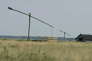
Geography of Hajdú-Bihar

The county of Hajdú-Bihar occupies the eastern part of Hungary. Most of its territory is completely flat and is part of the Pannonian Plain region (called the Grand Plain in the country) often referred to as the Northern Great Plain region. The highest point hardly rises over 170.5 metres in the north. It seems that the county slopes to the south because the lowest point is situated in this part of Hajdú-Bihar and hits the 85 metres height.
The wind and the nearby rivers formed and shaped the land for thousands of years. First the area of the present Hungary was occupied by an inland sea. Then, after some underground movement, the huge peaks of the Carpathians raised from this sea. The wild and rapid rivers of the mountains slowly made that inland sea disappear. After the great Hungarian plains were formed by the alluvial deposits of the rivers, the wind began to work and from the great rocks became smaller and smaller sand-grains, the so-called loess. This covers thickly the Hajdú-Bihar plains as well and ensures good crop in the agriculture.

There are two great rivers in this area, the Tisza and the Körös. The Hortobágy National Park area was formed by the first one. It used to be the flood area of the Tisza river and after the river was controlled, the Hortobágy went dry, resulting in a special fauna. The Hortobágy plain covering an area of about 800 km² is the largest protected area in Hungary and in Central Europe.
| |||||||||||||||||||||
