Geography of Haiti
| Geography of Haiti | |
|---|---|
 | |
| Continent | Americas |
| Region |
Caribbean Greater Antilles |
| Coordinates | 19°00′N 72°25′W / 19.000°N 72.417°W |
| Area | Ranked 147th |
| • Total | 27,750 km2 (10,710 sq mi) |
| Coastline | 1,771 km (1,100 mi) |
| Borders |
Total land borders: 376 km |
| Highest point |
Pic la Selle 2,680 m |
| Lowest point |
or Gheskio clinic, Port-au-Prince <0 m or Gonaïves, <-1 m |
| Longest river | Artibonite River |
| Largest lake | Étang Saumâtre |

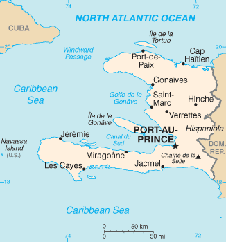
The Republic of Haiti comprises the western three-eighths of the island of Hispaniola, west of the Dominican Republic.[1][2] It is positioned between the Caribbean Sea and the North Atlantic Ocean. Haiti's geographic coordinates are at a longitude of 72° 25′ west and a latitude of 19° 00′ north. The total area is 27,750 square kilometres (10,714 sq mi), of which 27,560 square kilometres (10,641 sq mi) is land and 190 square kilometres (73 sq mi) is water. Haiti is slightly smaller than the U.S. state of Maryland. Haiti has 1,771 km (1,100 mi) of coastline and a 360 kilometres (224 mi)-border with the Dominican Republic.
Statistics
- Maritime claims
-
- Territorial sea: 12 nmi (22.2 km; 13.8 mi)
- Contiguous zone: 24 nmi (44.4 km; 27.6 mi)
- Exclusive economic zone: 200 nmi (370.4 km; 230.2 mi)
- Continental shelf: to depth of exploitation
- Climate
- Tropical; semiarid where mountains in east cut off trade winds
- Terrain
- Mostly rough and mountainous
- Natural resources
- Bauxite, copper, calcium carbonate, gold, marble, hydropower, arable land
- Land use
-
- Arable land: 36.28%
- Permanent crops: 10.16%
- Other: 53.56% (2012 est.)
- Irrigated land
- 970 km3
- Total renewable water resources
- 14.03 km3 (2011)
- Freshwater withdrawal (domestic/industrial/agricultural)
-
- Total: 1.2 km3/yr (17%/3%/80%)
- Per capita: 134.3 m3/yr (2009)
- Natural hazards
- Lies in the middle of the hurricane belt and subject to severe storms from June to October; occasional flooding and earthquakes; periodic droughts
- Environment—current issues
- Extensive deforestation (much of the remaining forested land is being cleared for agriculture and used as fuel); soil erosion; inadequate supplies of potable water
- Environment—international agreements
-
- Party to: Biodiversity, Climate Change, Desertification, Law of the Sea, Marine Dumping, Marine Life Conservation, Ozone Layer Protection
- Signed, but not ratified: Hazardous Wastes
Physical geography
Haiti is a very mountainous country with more than 3/4ths of the territory above 700 feet (210 m). Its climate is tropical and semiarid. Fertile valleys are interspersed between the mountain ranges forming vast areas of contrast between elevations in many areas throughout the territory. The country (and Hispaniola) is separated from Cuba by way of the Windward Passage, a 45 nmi (83 km; 52 mi) wide strait that passes between the two countries. Haiti's lowest elevation is reported by one source to be sea level (the Caribbean Sea[3]), by another source to be below sea level (Gheskio clinic, Port-au-Prince[4] or in Gonaïves, <-1m[5]), while its highest point is Pic la Selle at 2,680 m (8,793 ft).
Relief
- The country's most important valley in terms of crops is the Plaine de l'Artibonite, which is oriented south of the Montagnes Noires. This region supports the country's (also Ile d'Haiti's) longest river, the Riviere l'Artibonite whose watershed begins in the western region of the Dominican Republic and continues most of its length through central Haiti and onward where it empties into the Gulf of Gonâve. The river is navigable for a distance by barge. The eastern and central region of the island is a large elevated plateau.
- The northern region consists of the Massif du Nord (Northern Massif) and the Plaine du Nord (Northern Plain). The Massif du Nord is an extension of the Cordillera Central in the Dominican Republic. It begins at Haiti's eastern border, north of the Guayamouc River, and extends to the northwest through the northern peninsula. The Plateau Central (Central Plateau) extends along both sides of the Guayamouc River, south of the Massif du Nord. It runs from the southeast to the northwest. To the southwest of the Plateau Central are the Montagnes Noires, whose most northwestern part merges with the Massif du Nord.
- The southern region consists of the Plaine du Cul-de-Sac (the southeast) and the mountainous southern peninsula (also known as the Tiburon Peninsula). The Plaine du Cul-de-Sac is a natural depression which harbors the country's saline lakes, such as Trou Caïman and Haiti's largest lake Lac Azuei (also known as Etang Saumatre). The Chaîne de la Selle mountain range, an extension of the southern mountain chain of the Dominican Republic (the Sierra de Baoruco), extends from the Massif de la Selle in the east to the Massif de la Hotte in the west. This mountain range harbors Pic la Selle, the highest point in Haiti at 2,680 metres (8,793 ft).
Islands
Numerous smaller islands make up a part of Haiti's total territory. The most notable islands are:
- Île de la Gonâve, the largest offshore island of mainland Hispaniola, is located to the west-northwest of Port-au-Prince in Haiti's Gulf of Gonâve, in the Caribbean Sea (the largest gulf of the Antilles). It has an area of 743 km². Its Taíno name was Guanabo. La Gonâve was once a pirate base.
- Tortuga (Turtle), the second largest offshore island of the mainland, located off the northwest coast of Hispaniola, in the Caribbean Sea. It has an area of 180 km². The island was a major center of Caribbean piracy during the 17th century and has become famous in many works of literature and film. The island's name derives from the turtle-like shape of the island.
- Île à Vache (Island of Cows) is a small and lush island located off southwestern de l'Ile d'Haiti with a total area is 52 km².
- Les Cayemites, a pair of islands located in the Gulf of Gonâve off the coast of southwest Hispaniola. It has a combined area of 45 km².
- Lanavaz or Lavash, is a rocky outcropping that has been subject to an ongoing territorial dispute with the United States. The island is located 40 nautical miles (46 mi; 74 km) west of Jérémie on the south west peninsula of Haiti,[6] and measures 2 square miles (5.2 km2).
Haiti also harbors several lakes. The largest lake of Haiti, and the second largest lake of Ile d'Haiti and the West Indies, is Lake Azuei. It is located in the Cul-de-Sac Depression with an area of 170 km². It is a saline lake with a higher concentration of salt than the sea water and harbors numerous fauna such as American Crocodiles and American Flamingos.
Lake Peligre is an artificial lake created by the construction of the Peligre Hydroelectric Dam.
Trou Caïman is a saltwater lake with a total area of 16.2 km². Lake Miragoâne is one of the largest natural freshwater lakes in the Caribbean, with an area of 25 km².
Climate
The climate is tropical, with some variation depending on altitude. Port-au-Prince ranges in January from an average minimum of 23 °C (73.4 °F) to an average maximum of 31 °C (87.8 °F); in July, from 25–35 °C (77–95 °F). The rainfall pattern is varied, with rain heavier in some of the lowlands and on the northern and eastern slopes of the mountains. Port-au-Prince receives an average annual rainfall of 1,370 mm (53.9 in). There are two rainy seasons, April–June and October–November. Haiti is subject to periodic droughts and floods, made more severe by deforestation. Hurricanes are also a menace.
See also
References
- ↑ "Hispaniola Article". Britannica.com. Retrieved 4 January 2014.
- ↑ "Dominican Republic 2014". Retrieved 24 April 2014.
- ↑ CIA factbook
- ↑ Wall Street Journal, Feb 20-21, 2010
- ↑ Several sources, such as http://www.france24.com/en/20080911-disaster-aftermath-hurrican-ike-hanna-gonaives-haiti
- ↑ Rohter, Larry (October 19, 1998). "Whose Rock Is It? Yes, the Haitians Care". Port-au-Prince Journal. New York Times. Retrieved January 28, 2012.
External resources
| Wikimedia Commons has media related to Geography of Haiti. |
| ||||||||||||

| ||||||||||
| ||||||||||||||||||||||||||||||||||||||