Geography of French Polynesia
This article describes the geography of French Polynesia.
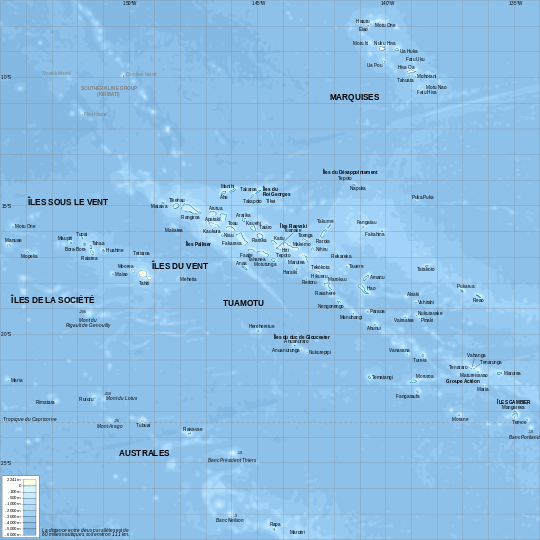
Map of French Polynesia
- Location
- Oceania, archipelago in the South Pacific Ocean, about half way between South America and Australia
- Geographic coordinates
- 15°00′S 140°00′W / 15.000°S 140.000°W
- Map references
- Oceania
- Area
-
- Total: 4,167 km² (Around 130 islands) [1]
- Land: 3,827 km²
- Water: 340 km²
- Land boundaries
- 0 km
- Coastline
- 2,525 km
- Maritime claims
-
- Territorial sea: 12 nm
- Exclusive economic zone: 200 nm
- Climate
- Tropical, but moderate
- Terrain
- Mixture of rugged high islands and low islands with reefs
- Elevation extremes
-
- Lowest point: Pacific Ocean 0 m
- Highest point: Mont Orohena ( Tahiti ) 2,241 m
- Natural resources
- Timber, fish, cobalt, hydropower
- Land use
-
- Arable land: 0.68%
- Permanent crops: 6.28%
- Other: 93.03% (2012)
- Irrigated land
- 10 km2 (2003)
- Natural hazards
- Occasional cyclonic storms in January
- Environment - current issues
- NA
- Geography - note
- Includes five archipelagoes: four volcanic islands and one coral; Makatea in French Polynesia is one of the three great phosphate rock islands in the Pacific Ocean - the others are Banaba (Ocean Island) in Kiribati and Nauru
See also
References
- ↑ Kingfisher Geography Encyclopedia. ISBN 1-85613-582-9. Page 546
| ||||||||||||||