Geography of Denmark
| Geography of Denmark | |
|---|---|
 | |
| Continent | Europe |
| Region | Northern Europe |
| Coordinates | 56°00′N 10°00′E / 56.000°N 10.000°E |
| Area | |
| • Total | 43,094 km2 (16,639 sq mi) |
| • Land | 98% |
| • Water | 2% |
| Coastline | 7,314 km (4,545 mi) |
| Borders |
Total land borders: 68 km |
| Highest point |
Møllehøj 171 m |
| Lowest point |
Lammefjord -7 m |

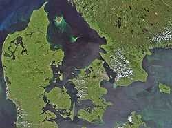
Denmark is a Nordic country located in Northern Europe. It consists of the Jutland peninsula and several islands in the Baltic sea, referred to as the Danish Archipelago. Denmark is located southwest of Sweden and due south of Norway and is bordered by the German state (and former possession) Schleswig-Holstein to the south, on Denmark's only land border, 68 kilometres (42 miles) long.
Denmark borders both the Baltic and North Seas along its 7,314 km (4,545 mi) tidal shoreline. Denmark's general coastline is much shorter, at 1,701 km (1,057 mi), as it would, among other geographical features, not include most of the 1,419 offshore islands (each defined as exceeding 100 square meters in area) and the 180 km long Limfjorden, which separates Denmark's second largest island, North Jutlandic Island, 4,686 km2 in size, from the rest of Jutland. A circle enclosing the same area as Denmark would be 742 km (461 miles) long. Denmark has 443 named islands,[1] of which 72 are inhabited (as of 1 January 2007, Statistics Denmark).
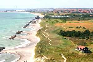
Denmark experiences a temperate climate. This means that the winters are mild and windy and the summers are cool. The local terrain is generally flat with a few gently rolling plains. The territory of Denmark includes the island of Bornholm in the Baltic Sea and the rest of metropolitan Denmark, but excludes the Faroe Islands and Greenland. Its position gives Denmark complete control of the Danish Straits (Skagerrak and Kattegat) linking the Baltic and North Seas. The country's natural resources include petroleum, natural gas, fish, salt, limestone, chalk, stone, gravel and sand.
Environment
|

Land use
- Arable land: 55.99%
- Permanent crops: 0.14%
- Other: 42.87% (2012)
- note: highest percentage of arable land in the world
Irrigated land: 4,354 km² (2007)
Total renewable water resources: 6 km3 (2011)
Freshwater withdrawal (domestic/industrial/agricultural):
total: 0.66 km3/yr (58%/5%/36%)
per capita: 118.4 m3/yr (2009)
Natural hazards
- Flooding is a threat in some areas of the country
Current issues
- Air pollution, principally from vehicle and power plant emissions
- Nitrogen and phosphorus pollution of the North Sea
- Drinking and surface water becoming polluted from animal wastes and pesticides
International agreements
- Party to: Air Pollution, Air Pollution-Nitrogen Oxides,
Air Pollution-Sulphur 85, Air Pollution-Sulphur 94, Air Pollution-Volatile Organic Compounds, Antarctic Treaty, Biodiversity, Climate Change, Desertification, Endangered Species, Environmental Modification, Hazardous Wastes, Law of the Sea, Marine Dumping, Marine Life Conservation, Nuclear Test Ban, Ozone Layer Protection, Ship Pollution, Tropical Timber 83, Tropical Timber 94, Wetlands, Whaling - Signed, but not ratified: Air Pollution-Persistent Organic Pollutants, Antarctic-Environmental Protocol, Climate Change-Kyoto Protocol
- Party to: Air Pollution, Air Pollution-Nitrogen Oxides,
Transnational issues
Maritime claims

- Contiguous zone: 24 nmi (44.4 km; 27.6 mi)
- Continental shelf: 200-m depth or to the depth of exploitation
- Exclusive economic zone: 200 nmi (370.4 km; 230.2 mi)
- Territorial sea: 12 nmi (22.2 km; 13.8 mi)
Other issues
- Iceland disputes the Faroe Islands' fisheries median line.
- Iceland, Ireland and the United Kingdom dispute Denmark's claim that the Faroe Islands' continental shelf extends beyond 200 nautical miles or about 370 km.
- The Faroe Islands continue to study proposals for full independence.
- Uncontested sovereignty dispute with Canada over Hans Island in the Kennedy Channel between Ellesmere Island and Greenland.
- Denmark is currently investigating the extent of the continental shelf of Greenland, in the hope that Greenland's Exclusive Economic Zone can be expanded. One of the areas investigated is the geographical North Pole.
Population
As of 2012 Denmark has a population of 5,543,453.[2] About a quarter of Danes live in the capital Copenhagen.
Notes
- Footnotes
- ↑ Islands in total and named islands
- ↑ "Denmark". The World Factbook. CIA. 3 August 2012. Retrieved 4 February 2012.
- Reference
The World Book Encyclopedia (2003 ed.). 1974. ISBN 0716601036.
See also
External links
![]() Media related to Geography of Denmark at Wikimedia Commons
Media related to Geography of Denmark at Wikimedia Commons
- Map of Denmark from the Atlas “Theatrum orbis terrarum” by Abraham Ortelius. It's the first printed map of Denmark.
| |||||||||||||||||||||||||||||||||||||||||||||

| ||||||||||||||||||
| ||||||||||||||||||