Geography of Aruba
| Nickname: One Happy Island | |
|---|---|
 Map of Aruba | |
 | |
| Geography | |
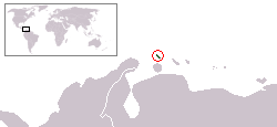
| Location | Caribbean Sea |
| Coordinates | 12°30′N 69°58′W / 12.500°N 69.967°W |
| Archipelago | ABC islands (Lesser Antilles) |
| Area | 139 km2 (54 sq mi) |
| Coastline | 68.5 km (42.56 mi) |
| Highest elevation | 188 m (617 ft) |
| Highest point | Mount Jamanota |
| Country | |
|
Aruba | |
| Largest settlement | Oranjestad (pop. 32,748) |
| Demographics | |
| Population | 104,494 (as of 2007) |
| Density | 751.76 /km2 (1,947.05 /sq mi) |
| Ethnic groups | Mixed Caribbean Amerindian and white |


Aruba is a small Caribbean island (54 sq mi or 140 km2) about the size of Washington, D.C., located 25 km north of the coast of Venezuela and 68 km northwest of Curaçao, the largest island of the Kingdom of the Netherlands. Aruba’s terrain is mostly flat with a few hills. There is little in the way of vegetation or outstanding physical features and no inland water. Aruba’s best-known geographical feature is its white-sand beaches, which are the basis of an active tourism industry that is the mainstay of the island’s economy. Aruba is situated on the Caribbean Tectonic Plate. Aruba, as well as the rest of the ABC islands and also Trinidad and Tobago, lies on the continental shelf of South America, and is thus geologically considered to lie entirely in South America.
The core of the island is made up of Turonian submarine and subaerial basalts which were formed in the Caribbean large igneous province. These basalts were intruded by a tonalite pluton shortly after their eruption. The shore areas are mainly limestone-capped hills and ridges, with cliffs on the northern and northeastern coasts and coral reefs on the southern coast.
Mountains and Hills
Aruba’s terrain is almost entirely flat. The highest elevation, so-called Mount Jamanota, is only 188 m above sea level. Rock formations characterize the interior of the island. (www.countyreports.org)
The Coast and Beaches
Aruba has three deepwater harbors located at Oranjestad, Barcadera, and San Nicolaas (Sint Nicolaas). The coastal area is known for its white-sand beaches and the calm waters surrounding Aruba are clear, making it a popular tourist destination.
Climate
Temperature
Aruba’s semi-arid tropical marine climate varies little seasonally, with an average annual temperature of 27 °C (80.6 °F), varying from about 26 °C (78.8 °F) in January to 29 °C (84.2 °F) in July.
Rainfall
Most rain brought by the prevailing easterly winds of the region falls on the Windward Islands of the Lesser Antilles, leaving Aruba with a very dry climate. Rainfall averages 510 mm (20.1 in) or less annually, and the island’s residents rely on one of the world’s largest desalination plants for most of their drinking water. The rainy season occurs between October and December.
Statistics
- Location
- Caribbean, island in the Caribbean Sea, north of Venezuela
- Geographic coordinates
- 12°30′N 69°58′W / 12.500°N 69.967°WCoordinates: 12°30′N 69°58′W / 12.500°N 69.967°W
- Map references
- Central America and the Caribbean
- Area
-
- Total: 193 km²
- Land: 193 km²
- Water: 0 km²
country comparison to the world: 108
- Area comparative
- slightly larger than Washington DC
- Land boundaries
- 0 km
- Coastline
- 68.5 km
- Maritime claims
The "Rijkswet" of December 12, 1985, for the maritime boundaries between The Netherlands Antilles and Aruba, and the Maritime Boundaries Treaty signed March 31, 1978, between the Republic of Venezuela and the Kingdom of the Netherlands, introduced December 12, 1978, and valid for Aruba since January 1, 1986.
- Territorial sea: 12 nmi (22.2 km; 13.8 mi)
- Climate
- Tropical semi-arid marine; little seasonal temperature variation
- Terrain
- Flat with a few hills; scant vegetation
- Elevation extremes
-
- Lowest point: Caribbean Sea 0 m
- Highest point: Mount Jamanota 188 m
- Best known: Hooiberg 165 m (541 ft)
- Natural resources
- Negligible; white sandy beaches
- Land use
-
- Arable land: 10.53% (including aloe 0.01%)
- Permanent crops: 0%
- Other: 89.47% (2005)
- Irrigated land
- 0.01 km² (1998 est.)
- Natural hazards
- While Aruba barely lies within the Caribbean hurricane belt, storms rarely if ever pass over the island.
- Environment—current issues
- NA
- Geography-note
- A flat, riverless island renowned for its white sand beaches; its tropical climate is moderated by constant trade winds from the Atlantic Ocean; the temperature is almost constant at about 27 degrees Celsius.
See also
External links
| Wikimedia Commons has media related to Geography of Aruba. |
- Map of Aruba PDF
- Map of Aruba
- Maps of Aruba (including island map, and detail maps of Oranjestad and San Nicolas)
| ||||||||||||||||||||||||||||||||||||||||||||||||
| ||||||||||||

| ||||||||||
| ||||||||||