General Sánchez Cerro Province
| General Sánchez Cerro | |
|---|---|
| Province | |
|
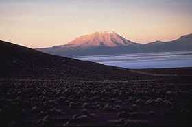
Ubinas volcano in the General Sánchez Cerro Province | |
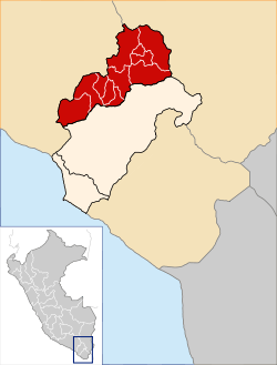 Location of General Sánchez Cerro in the Moquegua Region | |
| Country | Peru |
| Region | Moquegua |
| Capital | Omate |
| Government | |
| • Mayor | Mauricio Jose Nina Juarez (2007) |
| Area | |
| • Total | 5,681.71 km2 (2,193.72 sq mi) |
| Elevation | 2,166 m (7,106 ft) |
| Population | |
| • Total | 25,809 |
| • Density | 4.5/km2 (12/sq mi) |
| UBIGEO | 1802 |
The General Sánchez Cerro Province is the smallest of three provinces in the Moquegua Region of Peru.[1][2] The capital of the province is Omate. The province was named after the former Peruvian army officer and president Luis Miguel Sánchez Cerro.
Boundaries
- North: Arequipa Region
- East: Puno Region
- South: Mariscal Nieto Province
- West: Arequipa Region
Political division
The province is divided into eleven districts, which are:
Geography
One of the prominent peaks of the province is the Ubinas volcano. Other mountains are listed below:[3][4][5]
|
|
Ethnic groups
The province is inhabited by indigenous citizens of Aymara and Quechua descent. Spanish, however, is the language which the majority of the population (60.36%) learnt to speak in childhood, 37.45% of the residents started speaking using the Quechua language and 1.98% using Aymara (2007 Peru Census).[6]
See also
References
- ↑ (Spanish) INEI
- ↑ (Spanish) IPAM
- ↑ escale.minedu.gob.pe - UGEL map of the General Sánchez Cerro Province (Tacna Region)
- ↑ escale.minedu.gob.pe - UGEL map of the Mariscal Nieto Province (Tacna Region)
- ↑ escale.minedu.gob.pe - UGEL map of the Puno Province 1 (Puno Region)
- ↑ inei.gob.pe INEI, Peru, Censos Nacionales 2007
Coordinates: 16°40′27″S 70°58′13″W / 16.67417°S 70.97028°W