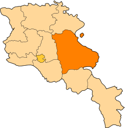
Gegharkunik Province
| Gegharkunik Գեղարքունիք | |
|---|---|
| Province | |
 Location of Gegharkunik within Armenia | |
| Coordinates: 40°25′N 45°12′E / 40.417°N 45.200°ECoordinates: 40°25′N 45°12′E / 40.417°N 45.200°E | |
| Country | Armenia |
| Capital | Gavar |
| Government | |
| • Governor | Nver Poghosian |
| Area | |
| • Total | 5,349 km2 (2,065 sq mi) |
| Area rank | 1st |
| Population (2011) | |
| • Total | 235,075 |
| • Rank | 7th |
| • Density | 44/km2 (110/sq mi) |
| Time zone | UTC+04 |
| • Summer (DST) | UTC+05 (UTC) |
| Postal code | 1201–1626 |
| ISO 3166 code | AM.GR |
| FIPS 10-4 | AM04 |
| Website | gegharkunik.gov.am |
| Part of a series on |
| Armenia Հայաստան |
|---|
  |
| Culture |
| History |
| Demographics |
| Administrative divisions |
|
| Armenia portal |
Gegharkunik (Armenian: Գեղարքունիք, Armenian pronunciation: [ɡɛʁɑɾkʰuˈnikʰ]) is a province (marz) of Armenia. Gegharkunik was named after Gegham. Gegham was a Haykazuni King and fifth generation after Hayk. Gegham was the father of Sisak of Syunid nobles and Arma the grandfather of Ara the Beautiful. Geghama mountains and Geghama lake, presently Lake Sevan, were named after Gegham.
Gegharkunik Province is in the east of Armenia, bordering Azerbaijan. At 5,348 km², Gegharkunik is the largest province in Armenia by area. However, approximately 1,278 km² of its territory is covered by Lake Sevan, the largest lake in the Caucasus and a major tourist attraction of the region. It has an exclave inside Azerbaijan, Artsvashen, which came under Azerbaijani control during the Nagorno-Karabakh War. Its capital is Gavar.
Location
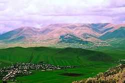
Gegharkunik is situated in the East of the territory of the Republic of Armenia, surrounding the Lake Sevan. It borders RA Lori and Tavush marzer from the North, from the East it borders the state border of Azerbaijan, from the South – RA Vayots Dzor marz, from South-West – RA Ararat marz and from the West – RA Kotayk marz. The longest extension of the marz from the North- West to the South-East comprised 115 km, from the West to the East – 85 km, the deepest landslide is the canyon of the Getik river (village of Dsoravank, 1325 m), the highest peak – Ajdahak mountain (3598 m). Yerevan-Sevan-Dilijan highway of republican importance runs through the territory of the marz. “South-North” highway passing through the mountain of Selim is being constructed.
Demographics
Demographics: Total population – 240.1 ths. (7.4% of the total population of Armenia) of which 160.6 ths. are rural population and 79.5 ths. urban. There are 5 towns and 87 rural communities.
Climate
The climate of Gegharkunik is mild mountainous. The winter is cold, snowy. The summer is warm, few clouds, comparatively humid weather. The Sevan Lake mitigates the winter frost and summer heat. Because of the lake, the average temperature in January is alsmost the same as in Yerevan. Precipitation is not abundant, 400-450mm on the lake surface, up to 1000 in the mountains.
Water Resources
Lake Sevan (1260 km2, 1898 m above sea level) is located in Gegharkunik marz. It is the largest pool of fresh water of the Southern Caucasus. The lake has vital influence not only on balance of environment protection but on economy of the whole marz as well. Other lakes are the comparatively small crater lakes of Ajdahak and Aghmaghani, up to 50 m in diameter and with a depth of 15 m.
The longest rivers are Gavaraget (47 km) and Masrik (45 km). Masrik is of great importance, since its a spawning place for such endemic species as the Gegharkunik trout (Salmo ishchan gegarkuni), the Sevan koghak (Capoeta capoeta sevangi) and the Sevan beghlu (Barbus geokschaikus). The young fish of these species live in these rivers till they are 1 year of age. The Sevan trout (Salmo ischchan) and Sevan beghlu are included in the Red Book of Armenia.
Specially protected areas
Sevan National Park
Sevan National Park was established in 1978 to protect Lake Sevan. It occupies the territories of the Lake Sevan comprising the bed of intermontane concavity of Sevan and those freed from its bed. The area comprises 1501 square kilometers, of which 24.9 thousand hectares are lakeside land. It is surrounded with the slopes of mountain chains of Areguni, Geghama, Vardenis, Pambak and Sevan. Some 1600 plant and 330 animal species are found here. The park is divided into 3 zones: a reserve, a recreation zone, and a zone for economic use.
Akhnabad Yew Grove State Reservation
Akhnabad Yew Grove State Reservation was established in 1958. It is located on Mt. Tsaghkot of the Miapor mountain range near Aghavnavank. The main species of the reservation is yew (taxus baccata L.). On the territory of the reservation yew grows in the mixed forest (beech, oak, maple etc.). Trees 300–400 years old, 25 m high and with 70–90 cm trunk diameter can be found there.
Getik State Reservation
Getik State Reservation was established in 1971. Main protected objects are forest fauna.
Juniper Forest State Reservation
Juniper Forest State Reservation was established in 1958. Main protected object is relict juniper, as well as other numerous species.
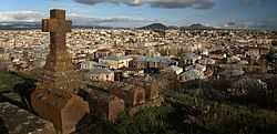
Communities
The province of Gegharkunik consists of the following 92 communities (hamaynkner), of which 5 are considered urban and 87 are considered rural.[1]
Towns or urban communities
| Image | City (town) | Province | Founded | Land area (km2) | Population (2011 est.) |
|---|---|---|---|---|---|
 | Chambarak | Gegharkunik | 1830s | 6 | 7,400 |
 | Gavar | Gegharkunik | 1830 | 16 | 25,800 |
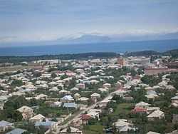 | Martuni | Gegharkunik | ? | 10 | 12,100 |
 | Sevan | Gegharkunik | 1842 | 8.5 | 21,900 |
 | Vardenis | Gegharkunik | 1830 | 10 | 12,700 |
Villages or rural communities
Non-community villages
- Barepat, belongs to the Kalavan community.
- Chapkut, belongs to the Aygut community.
- Gagarin, belongs to the Sevan community.
- Lernahovit, belongs to the Geghhovit community.
- Nshkhark, belongs to the Geghhovit community.
- Zariver, belongs to the Kutakan community.
- Gegharkunik
-
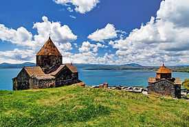
Sevanavank, 874 AD
-

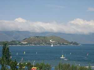
Hayravank, 9th century
-
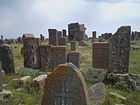
Noraduz cemetery, 10th century
-

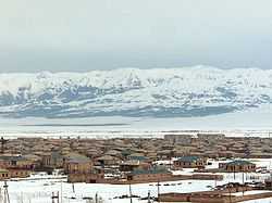
Ttujur village
References
- Report of the results of the 2001 Armenian Census, National Statistical Service of the Republic of Armenia
- ↑ "RA Gegharkunik Marz" (PDF). Marzes of the Republic of Armenia in Figures, 2002–2006. National Statistical Service of the Republic of Armenia. 2007.
External links
| Wikimedia Commons has media related to Gegharkunik marz. |
| ||||||||||||