Gaylord, Minnesota
| Gaylord, Minnesota | |
|---|---|
| City | |
 | |
| Motto: "The Hub Of Sibley County" | |
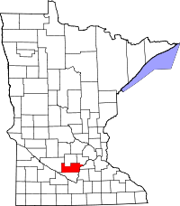
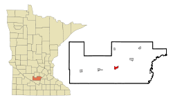 Location of Gaylord within Sibley County and state of Minnesota | |
| Coordinates: 44°33′22″N 94°13′10″W / 44.55611°N 94.21944°W | |
| Country | United States |
| State | Minnesota |
| County | Sibley |
| Government | |
| • Type | Mayor – Council |
| • Mayor | Don Boeder |
| Area[1] | |
| • Total | 1.67 sq mi (4.33 km2) |
| • Land | 1.67 sq mi (4.33 km2) |
| • Water | 0 sq mi (0 km2) |
| Elevation | 1,014 ft (309 m) |
| Population (2010)[2] | |
| • Total | 2,305 |
| • Estimate (2012[3]) | 2,287 |
| • Density | 1,380.2/sq mi (532.9/km2) |
| Time zone | Central (CST) (UTC-6) |
| • Summer (DST) | CDT (UTC-5) |
| ZIP code | 55334 |
| Area code(s) | 507 |
| FIPS code | 27-23300[4] |
| GNIS feature ID | 0644060[5] |
| Website | Exploregaylord.org |
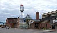
Gaylord is a city in Sibley County, in Minnesota, United States. Located along the shore of Titloe Lake, the community is approximately 50 miles (80 km) south of Minneapolis-St Paul.[6] The population was 2,305 at the 2010 census.[7] It is the county seat.[8]
Geography
According to the United States Census Bureau, the city has a total area of 1.67 square miles (4.33 km2), all of it land.[1] Minnesota State Highways 5, 19, and 22 are three of the main routes through the community.
History
A commonly used trail to the Dakota Territory passed through the future site of Gaylord in the 1850s. A roadhouse existed on the shore of Titloe Lake. Farms were established at the townsite in 1881, as land was surveyed along a planned railroad route. The surveyors named the site after E.W. Gaylord after determining that the name Maasville, after Alfred Maas, was too long. Elections were held and the village was incorporated in 1883. There had also been a feud between Henderson, MN, and Gaylord to determine what town would be the county seat of Sibley County. Henderson's thought was that it was right on the river, but Gaylord had more people and won the popular vote on the disagreement.[9]
Demographics
| Historical population | |||
|---|---|---|---|
| Census | Pop. | %± | |
| 1890 | 387 | — | |
| 1900 | 608 | 57.1% | |
| 1910 | 610 | 0.3% | |
| 1920 | 783 | 28.4% | |
| 1930 | 812 | 3.7% | |
| 1940 | 1,049 | 29.2% | |
| 1950 | 1,229 | 17.2% | |
| 1960 | 1,631 | 32.7% | |
| 1970 | 1,720 | 5.5% | |
| 1980 | 1,933 | 12.4% | |
| 1990 | 1,935 | 0.1% | |
| 2000 | 2,279 | 17.8% | |
| 2010 | 2,305 | 1.1% | |
| U.S. Decennial Census | |||
2010 census
As of the census[2] of 2010, there were 2,305 people, 929 households, and 590 families residing in the city. The population density was 1,380.2 inhabitants per square mile (532.9/km2). There were 996 housing units at an average density of 596.4 per square mile (230.3/km2). The racial makeup of the city was 87.6% White, 0.2% African American, 0.1% Native American, 1.2% Asian, 9.6% from other races, and 1.2% from two or more races. Hispanic or Latino of any race were 23.0% of the population.
There were 929 households of which 31.5% had children under the age of 18 living with them, 48.2% were married couples living together, 10.1% had a female householder with no husband present, 5.2% had a male householder with no wife present, and 36.5% were non-families. 32.6% of all households were made up of individuals and 16.7% had someone living alone who was 65 years of age or older. The average household size was 2.42 and the average family size was 3.05.
The median age in the city was 37.3 years. 27% of residents were under the age of 18; 8.2% were between the ages of 18 and 24; 23.6% were from 25 to 44; 22.6% were from 45 to 64; and 18.5% were 65 years of age or older. The gender makeup of the city was 49.2% male and 50.8% female.
2000 census
As of the census[4] of 2000, there were 2,279 people, 897 households, and 592 families residing in the city. The population density was 1,435.3 people per square mile (553.4/km²). There were 930 housing units at an average density of 585.7 per square mile (225.8/km²). The racial makeup of the city was 88.02% White, 0.18% African American, 0.61% Native American, 0.70% Asian, 9.78% from other races, and 0.70% from two or more races. Hispanic or Latino of any race were 17.38% of the population.
There were 897 households out of which 29.9% had children under the age of 18 living with them, 54.0% were married couples living together, 8.7% had a female householder with no husband present, and 33.9% were non-families. 29.1% of all households were made up of individuals and 16.5% had someone living alone who was 65 years of age or older. The average household size was 2.45 and the average family size was 3.01.
In the city the population was spread out with 24.7% under the age of 18, 8.4% from 18 to 24, 24.6% from 25 to 44, 21.2% from 45 to 64, and 21.0% who were 65 years of age or older. The median age was 38 years. For every 100 females there were 97.1 males. For every 100 females age 18 and over, there were 86.8 males.
The median income for a household in the city was $39,053, and the median income for a family was $45,750. Males had a median income of $29,167 versus $22,406 for females. The per capita income for the city was $17,048. About 9.4% of families and 13.6% of the population were below the poverty line, including 21.5% of those under age 18 and 8.5% of those age 65 or over.
Employment
Michael Foods is the largest employer, situated at the junction of Highways 5 and 19 on the east edge of the town. The second largest employer in the town is Sibley County, for which Gaylord is the county seat.
References
- ↑ 1.0 1.1 "US Gazetteer files 2010". United States Census Bureau. Retrieved 2012-11-13.
- ↑ 2.0 2.1 "American FactFinder". United States Census Bureau. Retrieved 2012-11-13.
- ↑ "Population Estimates". United States Census Bureau. Retrieved 2013-05-28.
- ↑ 4.0 4.1 "American FactFinder". United States Census Bureau. Retrieved 2008-01-31.
- ↑ "US Board on Geographic Names". United States Geological Survey. 2007-10-25. Retrieved 2008-01-31.
- ↑ Gaylord, Minnesota MN Community Profile: City Data, Resources, Maps
- ↑ "2010 Census Redistricting Data (Public Law 94-171) Summary File". American FactFinder. United States Census Bureau. Retrieved 27 April 2011.
- ↑ "Find a County". National Association of Counties. Retrieved 2011-06-07.
- ↑ City of Gaylord - Gaylord History
External links
| Wikimedia Commons has media related to Gaylord, Minnesota. |
| |||||||||||||||||||||||||
Coordinates: 44°33′11″N 94°13′13″W / 44.55306°N 94.22028°W