Gaspésie National Park
| Parc national de la Gaspésie | |
|---|---|
|
IUCN category II (national park) | |
|
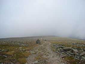
Summit of Mount Jacques-Cartier | |
| Location | La Haute-Gaspésie and La Matanie RCMs, Quebec, Canada |
| Nearest city | Sainte-Anne-des-Monts |
| Coordinates | 48°56′00″N 66°14′00″W / 48.93333°N 66.23333°WCoordinates: 48°56′00″N 66°14′00″W / 48.93333°N 66.23333°W |
| Area | 80,200 hecatres[1] |
| Established | November 25, 1981[2] |
| Governing body | Sépaq |
Gaspésie National Park (French: Parc national de la Gaspésie) is a provincial park located south of the town of Sainte-Anne-des-Monts, Quebec, Canada in the inland of the Gaspé peninsula. The park contains the highest peak of the Appalachian Mountains in the province of Quebec and the only population of Caribou found south of the Saint Lawrence River in Canada.

A panorama of the mountains in Gaspésie National Park
See also
- List of Quebec provincial & national parks
- National Parks of Canada
- List of National Parks of Canada
External links
| Wikivoyage has a travel guide for Gaspésie National Park. |
References
- ↑ - Registre des aires protégées au Québec - Ministère du Développement durable, de l’Environnement et des Parcs du Québec, Retrieved on September 19, 2007
- ↑ Existing Park - Ministère du Développement durable, de l’Environnement et des Parcs, Retrieved on September 19, 2007